Maps of Spain

The seat of war on the coast of France being a new chart of the coast of Holland, Flanders, France, Spain & Portugal, with the adjacent islands, part of Barbary, England and Ireland
Anglie Bowen, Emanuel T. Jefferys
[Jihozápadní Evropa]
1 : 5800000 Evropa jihozápadní
France.
from A new systeme of the mathematicks: containing I. Arithmetick, as well natural and decimal, as in species, or the principles of algebra. II. Practical geometry, together with the first six books of Euclid's Elements, as also the eleventh and twelfth, symbo
France, Spain, and Portugal.
1 : 3650000 Johnson, A.J.
France, Spain, and Portugal.
1 : 3650000 Johnson, A.J.
Map of France, Spain, and Portugal; Switzerland in cantons [inset]; Island of Corsica [inset].
from Mitchell's new general atlas, containing maps of the various countries of the world, plans of cities, etc., embraced in fifty-three quarto maps., forming a series of eighty four maps and plans, together with valuable statistical tables.
France, Spain, and Portugal.
1 : 3658000 Johnson, A.J.
Western Europe.
1 : 7303000 Fisher, Richard Swainson
Carte generale de toute l'Europe, 4
1 Blatt : 56 x 48 cm J.M. Will
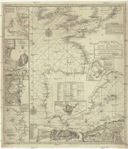
Paskaert van Spanjen, vertoonende de Kusten van Granade, Andaluzie, Algarve, Portugael, Galissen en Biscajen, met een gedeelte van Vranckrijck streckende van Heyssant tot de Straet van Gibralter.
from De zee-atlas ofte water-wereld : waer in vertoont werden alle de zee-kusten van het bekende des aerd-bodems : seer dienstigh voor alle heeren en kooplieden, als oock voor alle schippers en stuurlieden / by Pieter Goos.
France, Spain, and Portugal.
1 : 3650000 Johnson, A.J.
Spain, Portugal, W. France.
1 : 3000000 Philip, George
XI. Charte für die allgemeine Geschichte von der Selbstregierung Ludwig XIV. bis auf den österreichischen Erbfolgekrieg : d.i. von 1661 bis 1740 n. Christus
Entworfen von F.W. Benicken A. Falger gr. Weimar : im Verlage des L. Industrie-Comptoirs
Hispania III. Nova Tabula [Karte], in: Claud. Ptolemaeus. Geographia lat. cum mappis [...], S. 338.
1 Karte aus Atlas Münster, Sebastian [und Ptolemaeus, Claudius]
Regnorum Hispaniae nova descriptio
1 mapa, col.. Text: francès. Reclam: A, 1. - Originàriament dins: Le Theatre du monde ou novvel atlas, mis en lumiere par Gvillavme & Iean Blaeu. Amsterdam, 1643. Blaeu, Willem Jansz.; Blaeu, Joan mis en lumiere par Gvillavme & Iean Blaeu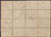
L'Espagne divisée en tous ses Royaumes Et Principautés [...] [Karte], in: Atlas nouveau, contenant toutes les parties du monde [...], Bd. 2, S. 107.
1 Karte aus Atlas Sanson, Nicolas Jaillot, Alexis Hubert und Mortier, Pieter
Tabula Moderna Hispanie [Karte], in: [Clavdii Ptholomei Cosmographi ...], S. 251.
1 Karte aus Atlas Nicolaus Germanus [und Ptolemaeus, Claudius]
Hispania III. Nova Tabula [Karte], in: Geographia universalis vetus et nova complectens Claudii Ptolemaei Alexandrini enarrationis libros VIII, S. 308.
1 Karte aus Atlas Münster, Sebastian [und Ptolemaeus, Claudius]
Hispaniae Veteris Descriptio. [Karte], in: Theatrum orbis terrarum, S. 459.
1 Karte aus Atlas Ortelius, Abraham Vrients, Jan Baptista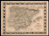
Carte administrative, physique et routiere de l'Espagne et du Portugal indiquant les canaux, les rivieres naviables, les routes de poste et les nouvelles divisions des provinces, &c.
1 Mapa, col. Orla amb 32 vistes de ciutats i monuments. - Limits acolorits Dufour, A.-H. Dufour, Bulla et Jouy
Hispaniae Veteris Descriptio.[Karte] [Iulia Gaditana Aug. und Umgebung] [Nebenkarte], in: Gerardi Mercatoris et I. Hondii Newer Atlas, oder, Grosses Weltbuch, Bd. 2, S. 207.
1 Karte aus Atlas Mercator, Gerhard und Hondius, Jodocus Jansson, Jan
Hispaniae Veteris Descriptio. [Karte] [Blastophoenices, Region Cádiz] [Nebenkarte], in: Theatrum orbis terrarum, S. 368.
1 Karte aus Atlas Ortelius, Abraham
Hispaniae Veteris Descriptio. [Karte] [Iulia Gaditana Aug. und Umgebung] [Nebenkarte], in: Novus atlas absolutissimus, Bd. 6, S. 8.
1 Karte aus Atlas Janssonius Offizin
Mapa de España y Portugal: dividido en sus actuales provincias y orlado con los de las posesiones ultramarinas españolas y los planos de las principales ciudades
1 : 800000 . Conté 3 mapes: Islas Canarias, Islas Antillas, Islas Filipinas; i 8 plantes de ciutats: S. Sebastián, Sevilla, La Habana, Madrid, Palma, Zaragoza, Valencia, Barcelona. - Fotografia: T-VI-1-17698 Martín de López, Pedro; Alabern, Ramon Gaspar y Roig
Carte générale de l'Espagne et du Portugal / par A.H. Brué
1 Mapa. Atlas universel; 22 Brué. Adrien-Hubert chez l'auteur et chez Simonneau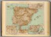
37-38. Spagna, Portogallo.
1 : 3000000 Touring club italiano
Spanien und Portugal
E. von Sydow's Schul-Atlas in sechs und dreissig Karten Sydow, Emil von bei Justus Perthes
Die iberische Halbinsel bis in die Mitte des XIIIten Jahrhundert's.
1 : 3800000 Spruner von Merz, Karl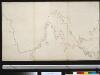
De Westkust van Europa van Texel tot Kaap Finisterre
Europe Gerard van Keulen