Maps of Upper Bavaria

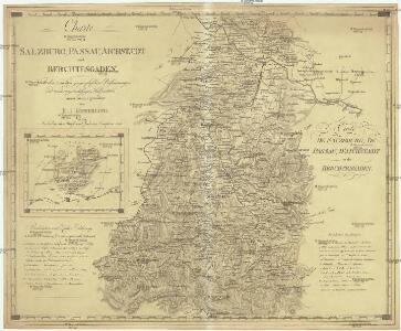
Charte von Salzburg, Passau, Aichstaedt und Berchtesgaden
1 : 530000 Berchtesgaden (Německo) Kipferling, Karl Joseph Kunst und Industrie Comptoirs
Charte von Salzburg, Passau, Aichstaedt und Berchtesgaden
1 : 535000 Berchtesgaden (Německo) Kipferling, Karl Joseph Kunst und Industrie Comptoirs
Charte von Salzburg, Passau, Aichstædt und Berchtesgaden
1 Karte : Kupferdruck ; 45 x 55 cm Kipferling Im Verlage des Kunst und Industrie Comptoirs
Circulus Bavaricus in qúo súnt Ducatus, Electoratus, & Palatinat Bavariae, Archiepisc: Salisburgi, Episcopatus Ratisbonae, Pataviae,& Fruxini, Palatinat Neoburgi & Landgraviatus Leuchtenbergi
1 : 630000 Mollova mapová sbírka Wit, Frederik de Wit, Frederick
Circulus Bavaricus in qúo súnt Ducatus, Electoratus, & Palatinat Bavariae, Archiepisc: Salisburgi, Episcopatus Ratisbonae, Pataviae,& Fruxini, Palatinat Neoburgi & Landgraviatus Leuchtenbergi
1 : 630000 Mollova mapová sbírka Wit, Frederik de Wit, Frederick
Königreich Bayern
Grosser Hand-Atlas über alle Theile der Erde in 170 Karten Meyer, J. Verlag des Bibliographischen Instituts
Tipus Vindelicae Sive Utriusque, Bavariae, secundum [Karte], in: Theatrum orbis terrarum, S. 72.
1 Karte aus Atlas Ortelius, Abraham
Bavaria dvcatvs
1 Karte : Kupferdruck ; 37 x 49 cm Blaeu; Mercator apud Guiljelmum Blaeu
Bavaria ducatus
1 Karte : Kupferdruck ; 21 x 27 cm Quad; Bussemacher excudit Iohan Bussemacher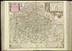
[51][51] Circulus Bavaricus ..., uit: Atlas sive Descriptio terrarum orbis
Annotatie: Gedigitaliseerde versie. Amsterdam. Heiloo : Picturae (vervaardiger), 2015. tiff-bestand. Gedigitaliseerd: 07-01-2015; Origineel: Universiteitsbibliotheek Vrije Universiteit (XL.05127.-) ; Netherlands; Titelpagina ontbreekt Wit, Frederik de Amsterdam : Frederick de Wit
VII, uit: General-Karte des oesterreichischen Kaiserstaates mit einem grossen Theile der angrenzenden Länder / durch Josef Scheda ... bearb. und hrsg
1 : 576000 Annotatie geografische gegevens: Maatstokken: oesterreichische Meilen, geografische oder deutsche Meilen, preussische Meilen, türkische Berri, französische Lieues, russische Werste; Maatstok per blad: wiener Klafter, öster. Meilen; Blad XIX: statistische en taalkundige informatie; Blad XIX: legenda [Wien : K.K. Militärisch-Geografisches Institut]
Le cercle de Baviere Divisée en touts les estats qui le Composent &c.
1 : 575000 Mollova mapová sbírka Covens, Johannes I
Bavaria Ducatus [Karte], in: Gerardi Mercatoris Atlas, sive, Cosmographicae meditationes de fabrica mundi et fabricati figura, S. 385.
1 Karte aus Atlas Mercator, Gerhard Montanus, Petrus
Bavaria Ducatus [Karte], in: Theatrum orbis terrarum, sive, Atlas novus, Bd. 1, S. 271.
1 Karte aus Atlas Blaeu, Joan Blaeu, Willem Janszoon
Bavaria Ducatus [Karte], in: Gerardi Mercatoris et I. Hondii Newer Atlas, oder, Grosses Weltbuch, Bd. 1, S. 304.
1 Karte aus Atlas Mercator, Gerhard und Hondius, Jodocus Jansson, Jan
Bavaria Ducatus [Karte], in: Novus Atlas, das ist, Weltbeschreibung, Bd. 1, S. 222.
1 Karte aus Atlas Blaeu, Joan Blaeu, Willem Janszoon
Bavaria Ducatus [Karte], in: Le théâtre du monde, ou, Nouvel atlas contenant les chartes et descriptions de tous les païs de la terre, Bd. 1, S. 254.
1 Karte aus Atlas Blaeu, Willem Janszoon und Blaeu, Joan Blaeu, Willem Janszoon

Sheet VII: Karte Des Oesterreichischen Kaiserstaates.
1 : 576000 Scheda, Josef
Bavaria dvcatvs
1 Karte : Kupferdruck ; 35 x 46 cm Mercator; Hondius excusum apud Henricum Hondium sub insigno Atlantis
Bavaria dvcatvs
1 Karte : Kupferdruck ; 35 x 45 cm Mercator s.n.
BAVARIA | DVCATVS
Per Ger. Mercatorem Apud Guiljelmum Blaeu

Das Kurfürstenthum Salzburg
1 Karte : Kupferdruck ; 63 x 45 cm Winckelhofer in der kaiserl. privil. Kunsthandlung Adam Gottlieb Schneider u: Weigels
Circulus Bavaricus
1 Karte : Kupferdruck ; 47 x 55 cm Wit ex officina I. Cóvens et C. Mortier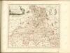

L'archeveché de Saltzbourg
1 Karte : Kupferdruck ; 48 x 55 cm Le Rouge Georges Louis Le Rouge rue des Grands Augustins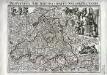
Provincia archiepiscopatus Salisburgensis
1 Karte : Kupferdruck ; 25 x 35 cm Gutwein; Hansiz M. Happach & F.X. Schlüter