Maps of Slovenia

Karte von Inneroesterreich oder das Herzoghtum Steyermark, Kaernthen und Krain
1 : 1080000 Korutansko (Rakousko) T. Mollo
Partie Du Cercle D'Austriche, Ou Sont Les Duchés De Stirie, De Carinthie, De Carniole, et autres Estats Hereditaires al la Maison d'Austriche. [Karte], in: Atlas nouveau, contenant toutes les parties du monde [...], Bd. 1, S. 254.
1 Karte aus Atlas Sanson, Nicolas Jaillot, Alexis Hubert und Mortier, Pieter
Partie du cercle d'Austriche ou sont les duchés de Stirie, de Carinthie, de Carniole et autres estats hereditaires a la maison d'Austriche
Kärnten, Steiermark Sanson, Guillaume ; Jaillot, Alexis Hubert
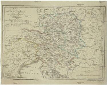
Karte von Innerösterreich
1 : 800000 Bosanska Krajina (Bosna a Hercegovina) Mollo, Tranquillo bey Tranquillo Mollo
Carte internationale du monde au 1,000,000 E
1 : 1000000 Terst (Itálie) Istituto geografico militare
Charte von Innerostreich od. den Herzogthumern Steyermark, Kaernten u. Krain, mit den Gebiethen v. Gorz u. Triest
1 : 650000 Chorvatsko Streit, Friedrich Wilhelm Liechtenstern, Joseph Marx von
Königreich Illyrien nach der neuesten Eintheilung
1 : 1250000 Balkánský poloostrov
Königreich Illyrien nach der neuesten Eintheilung
1 : 1250000 Balkánský poloostrov
Severovýchodní Italie a alpské země rakouské s Přímořím, Istrii [sic] a Chorvatskem
1 : 1000000 Alpy rakouské-oblast Emil Šolc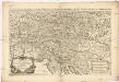
Partie du cercle d'Austriche, ou sont les duchés de Stirie, de Carinthie, de Carniole et autres estats heriditaires a la maison d'Austriche
1 : 630000 Korutansko (Rakousko) Sanson, Guillaume Jaillot, Alexis-Hubert H. Iaillot
Karnthen, Krain, Gorz-Gradisca, Istrien, Triest.
1 : 875000 Flemming, Carl
Süd-östliches Deutschland
1 : 1850000 Evropa jihovýchodní Stieler, Adolf
Königreich Illyrien
1 : 1250000 Evropa jihovýchodní Mollo, Tranquillo Tranquillo Mollo
Ost-Alpenländer
Neuer Handatlas über alle Theile der Erde Kiepert, Heinrich Verlag von Dietrich Reimer
Königreich Illyrien
1 : 1233000 Ilýrie
Karte der Kroländer Steyermark, Kärnthen, Krain und Istrien
1 : 1530000 Istrijský poloostrov (Slovinsko a Chorvatsko) Marco Berra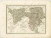
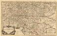
Partie du Cercle d'Austriche, ou sont Les Duchés de Stirie, de Carinthie, de Carniole
1 : 650000 Mollova mapová sbírka Sanson, Guillaume Jaillot, Alexis Hubert
Bez titulu: Slepá hydrografická mapa jihovýchodní Evropy

Vindové
Chorvatsko Müller, Jos. D. Jungmann, C.
Carte du royaume d'Illirie et du duché de Styrie
1 : 520000 Ilýrie Raffelsperger, Franz Rumpold, F. au Dépôt des cartes typografiées
Karte von Inner-Österreich, das ist des Königreiches Illirien und des Herzogthumes Steiermark
1 : 880000 Ilýrie Raffelsperger, Franz Rumpold, F. im Typographischen Landkarten-Verlage
Das Königreich Illyrien und das Herzogthum Steyermark
1 : 700000 Ilýrie Weiland, Karl Ferdinand im Verlage des geographischen Instituts
Oesterr. Kronlander.
1 : 700000 Weiland, C. F. (Carl Ferdinand), d. 1847
Übersichts Karte von Inner Österreich
1 : 575000 Korutansko (Rakousko) Schwab, G.
Herzogthümer Steiermark, Kärnten, Krain, die gefürstete Graftschaft Görz und Gradiska, die Markgraftschaft Istrien, die Stadt Triest mit Gebiet und das ungarische Littorale
1 : 600000 Steiermark, Kärnten Gräf, Carl
Carte del regno d'Illiria e del ducato Stiria
1 : 860000 Ilýrie Raffelsperger, Franz nel magazeno delle carte tipografiate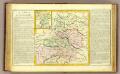
Cercle d'Autriche.
1 : 1450000 Clouet, J. B. L. (Jean-Baptiste Louis), b. 1730
Das Königreiche Illyrien und das Herzogthum Steyermark
1 : 700000 Ilýrie Weiland, Karl Ferdinand Anson im Verlage des geographischen Instituts
Das Königreiche Illyrien und das Herzogthum Steyermark
1 : 700000 Ilýrie Weiland, Karl Ferdinand Anson im Verlage des geographischen Instituts
Charte von dem Königreiche Illyrien und dem Herzogthume Steyermark
1 : 690000 Ilýrie Weiland, Karl Ferdinand Bürck, A. im Verlage des Geograph. Instituts