Maps of Balkan Pen.
Neu und accurat verfaste general Post Land-Karte des sehr grosen Welt berühmten Konig-Reichs Hungarn
1 : 1400000 Uhersko Lidl, Johann Jakob Harach, Johann Joseph Philipp von J. J. Lidl
Nova et Accurata Tabula Sedis Belli in Regno
1 : 1500000 Mollova mapová sbírka Schenk, Pieter Schenk, Peter II
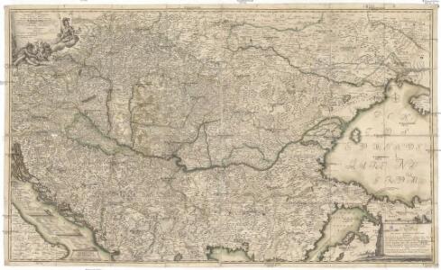
Accurate Landkarte die Königreiche Ober- und Nieder-Hungarn, Slavonien, Croatien, Dalmatien, Bosnien, Servien, Bulgarien, und Romanien, das Groß Fürstenthum Siebenbürgen, die Fürstenthümer Moldau, Wallachey, Bessarabien, die Oczakowisch- und Crimische Tartarey, die Pohlnische Provinz Podolien, wie auch ein Theil von Ukranien, und übrige angränzende Ländere
Mollova mapová sbírka Lidl, Johann Jakob Lidl, Johann Jacob
Le royaume de Hongrie et les estats qui en ont esté sujets, et qui font presentement la partie septentrionale de la Turquie en Europe
1 : 2250000 Bosna Sanson, Guillaume Jaillot, Alexis-Hubert chez H. Iaillot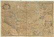
Le royaume de Hongrie
1 : 2300000 Bosna Sanson, Nicolas H. Iaillot
HVNGARIAE
1 : 860000 Bosna Hase, Johann Matthias curantibus Homannianis Heredibus
Hvngariae
1 : 860000 Bosna Hase, Johann Matthias curantibus Homannianis Heredibus
Hvngariae
1 : 860000 Bosna Hase, Johann Matthias curantibus Homannianis Heredibus
Hungaria Generalis
1 : 2300000 Mollova mapová sbírka Valk, Gerhard Valck, Gerard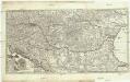
Novissima et accuratissima toti. regni Hungariae, Dalmatiae, Croatiae, Sclavoniae, Bosniae, Serviae, Transylvaniae, cum adiacentib. regnis et provinciis tabula
1 : 1600000 Bosna Sandrart, Johann Jakob von J. J. von Sandrart
Hungariae
1 : 2600000 Balkánský poloostrov Hase, Johann Matthias Homannianos Heredes
HUNGARIAE ampliori significatu et veteris vel Methodicae, complexae REGNA
1 : 2600000 Bosna Hase, Johann Matthias curantibus Homannianis Heredibus
Hungariae
1 : 2600000 Balkánský poloostrov Hase, Johann Matthias Homannianis Heredibus
Tabula Hungaria et regionum, quae praeterea ab ea dependent, delineata juxta magnum numerum an[n]otationum et mappas manuscriptas vel impressas
1 : 2600000 Evropa jihovýchodní Delisle, Guillaume Lotter, Georg F. Tob. Conr. Lotter
Tabula Hungaria et regionum, quae praeterea ab ea dependent, delineata juxta magnum numerum an[n]otationum et mappas manuscriptas vel impressas
1 : 2600000 Evropa jihovýchodní Delisle, Guillaume Lotter, Georg F. Tob. Conr. Lotter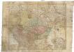
Tabula Hungaria et regionum, quae praeterea ab ea dependent, delineata juxta magnum numerum an[n]otationum et mappas manuscriptas vel impressas
1 : 2600000 Evropa jihovýchodní Delisle, Guillaume Lotter, Georg F. Tob. Conr. Lotter
Tabula Hungaria et regionum, quae praaeterea ab ea dependent, delineata juxta magnum numerum an[n]otatium et mappas manuscriptas vel impressas
1 : 2300000 Maďarsko Delisle, Guillaume Lotter, Georg F. T. C. Lotter
Tabula Hungaria et regionum, quae praaeterea ab ea dependent, delineata juxta magnum numerum an[n]otatium et mappas manuscriptas vel impressas
1 : 2300000 Maďarsko Delisle, Guillaume Lotter, Georg F. T. C. Lotter
Carte générale du royaume d'Ongrie et des provinces limitrophes
1 : 2300000 Evropa jihovýchodní Lotter, Matthäus Albrecht
Nieuwe kaart van Hongarien en het noordelyke deel van Turkyen
1 : 5000000 [S.l.] : [s.n.]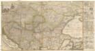
Accurate Landkarte die Königreiche Ober- und Nieder- Hungarn, Slavonien, Croatien, Dalmatien, Bosnien, Servien, Bulgarien und Romanien, das Gross Fürstenthum Siebenbürgen, die Fürstenthümer Moldau, Wallachen, Bessarabien, die Oczakowisch- und Crimische Tartaren, die Pohlnische Provinz Podolien, wie auch ein Theil von Ukranien, und übrige angränzende Ländere vorstellend
1 : 1430000 Besarábie (Moldavsko a Ukrajina) Lidl, Johann Jakob Joh. Jacob Lidl

Nova et Accurata Regni Hungariae Tabula, ad Usum Serenissimi Burgundiae Ducis
1 : 2500000 Mollova mapová sbírka Delisle, Guillaume Covens, Johannes I
Regnum Hungariae, in quo continentur Regiones
1 : 5900000 Mollova mapová sbírka Bruggen, Johann van der Brugge, Johannes van der
Regnum Hungariae, in quo continentur Regiones :
1 : 5900000 Mollova mapová sbírka Bruggen, Johann van der Brugge, Johannes van der
Hvngariae ampliori significatu et veteris vel Methodicae, complexae Regna: Hvngariae Propriae, Croatia, Dalmatiae, Bosniae, Serviae, Bvlgariae, Cvmaniae, Principatvm: Transsylvaniae, Despotatvs: Walachiae, Moldaviae, exclusis ab eadem alienatis Galitia et Lvdomiriria in suas Provincias ac partes divisae et quoad Imperantes ex Avstriacis, Tvrcis et Venetis distinctae juncta tamen propter commoditatem Romania vel Romelia Tvrcica Tabvla ex recentissimis pariter et antiquissimis relationibus et monumentis concinnata, ac secundum leges Projectionis Stereographicae legitimae descrita a
1 : 2500000 Mollova mapová sbírka Hase, Johann Matthias Homann, Johann Baptista - dědici
Le Royaume de Hongrie et des pays qui en dependoient autrefois ; Nova et accurata Regni Hungariae tabula, ad usum serenissimi Burgundiae ducis
Ungarn, Osmanisches Reich L'Isle, Guillaume de
Hvngariae ampliori significatu et veteris vel methodicae complexae regna: Hvngariae propriae, Croatiæ, Dalmatiae, Bosniae, Serviae, Bvlgariae, Cvmaniae, principatvm: Transylvaniae, despotatvs: Walachiae, Moldaviae [exclusis ab eadem alienatis Galitia et Lvdomiriria] in suas provincias ac partes divisae et quo ad imperanies ex Avstriacis, Tvrcis et Venetis distinctae [juncta tamen propter comoditatem Romania vel Romelia tvrcica] tabvla
1 Karte : Kupferdruck ; 45 x 57 cm Haas curantibus Homannianis Heredibus