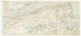
Maps of Atlas Mountains
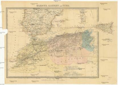
Marocco, Algerien und Tunis
1 : 6000000 Afrika severní Hochdanz, Emil Leo Woerl
Aphrica Tabula I. [Karte], in: Geographia universalis vetus et nova complectens Claudii Ptolemaei Alexandrini enarrationis libros VIII, S. 254.
1 Karte aus Atlas Münster, Sebastian [und Ptolemaeus, Claudius]
Ancient Africa or Libya I.
1 : 5730000 Society for the Diffusion of Useful Knowledge (Great Britain)

In notitiam ecclesiasticam Africæ tabula geographica
1 : 5700000
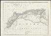
Nord-Africa Berberei
1 : 9678000 Afrika severní Schlieben Gleditsch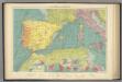
W. Mediterranean.
1 : 5000000 Philip, George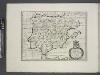
Spain, or Celtiberia.
from A new sett of maps both of antient and present geography : wherein not only the latitude and longitude of many places are corrected according to the latest observations, but also the most remarkable differences of antient and present geography may be quickly discern'd by a bare inspection or comparing of correspondent maps, which seems to be the most natural and easy method to lead young students (for whose use the work is principally intended) unto a competent knowledge of the geographical science : together with a geographical treatise particularly adapted to the use and design of these maps / by Edward Wells, M.A. and student of Christ-Church, Oxon.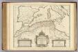
Africae Tabula Geographica.
1 : 4500000 L'Isle, Guillaume de, 1675-1726
La mer Mediterranée vers l'occident
1 Karte : Kupferdruck ; 38 x 49 cm Duval P. Duval
Africae tabula geographica.
1 : 5700000 L'Isle, Guillaume de, 1675-1726
In notitiam ecclesiasticam Africae tabula geographica
1 : 4500000 L'Isle, Guillaume de, 1675-1726 Apud Auctorem, Via vulgo dicta des Canettes propè Sancti Sulpitii fanum
Hispania
Kartágo (zaniklé město)
Hispania, Mauretania et Africa.
1 : 5000000 Kiepert, Heinrich, 1818-1899
Pascaarte Van't westlyckste deel vande Middelandsche-Zee [...] [Karte], in: Het vijfde Deel Des Grooten Atlas : Vervatende De Water-Weereld, S. 187.
1 Karte aus Atlas Jansson, Jan Jansson, Jan
Pascaarte Van 't westlyckste deel vande Middelandsche-Zee [...] [Karte], in: Novus atlas absolutissimus, Bd. 9, S. 253.
1 Karte aus Atlas Janssonius Offizin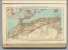
112. Marocco, Algeria, Tunisia.
1 : 5000000 Touring club italiano
Mare Mediterraneum, 1
1 Blatt : 47 x 58 cm G. und L. Valck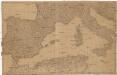
[Spanien und Italien]
Itálie Adam, Jakob
Atlas für Handel und Industrie: Für Kaufleute, Fabrikante u. Gewerbetreibende, Handlungs- u. Gewerbe-Schulen

Carte de la Mer Méditerranée, 1
1 Blatt : 50 x 51 cm Froullé
Ooster Deel der Middelandsche Zee [Karte] [Bona.] [Saragoßa.] [C. Carbonera] [Baya de Agde in Languedoq.] [Alcol] [P. Farina.] [Susa.] [Alzyra.] [8 Nebenkarten], in: De Nieuwe Groote Vermeerderde Zee-Atlas ofte Water-Werelt, S. 51.
1 Karte aus Atlas Doncker, Hendrick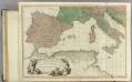
Mediterranean W.
1 : 2850000 Faden, William, 1750?-1836
Paskaert van 't westelycke deel der Middelandsche Zee
1 Karte : Kupferdruck ; 41 x 51 cm Doncker by Hendrick Doncker boekverkoper en graadbooghmaker inde Nieuwbrugsteegh in 't Stuurmans gereedschap
Africa, North Part. Africa South Part.
1 : 8800000 Hughes, William
Podrobná politická mapa Evropy
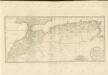
Karte von Marocco, Algier & Tunis : nach der Carte de L'Algérie dressée au Dépôt Général de la Guerre sous la direction de Pelet d'après les levés et les reconnaissances des Officiers d'Etat-major, les relèvemens de la Marine, les renseignemens recueillis en Afrique, les itineraires anciens et les voyages modernes de Shaw, Peyssonel &a. und nach J. Arrowsmith
1 : 3150000 entworfen, gezeichnet und graviert von Albrecht Platt Magdeburg : Geogr. lith. Institut v. Albr. Platt
La Mediterranée, 1
1 Blatt : 53 x 63 cm Le Rouge