Maps of Angola
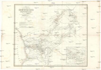
Carte d'une partie de l'Afrique équinoxiale
1 : 3300000 Angola Brué, A. M. Jules Renouard
Carta de Angola
1 : 2000000 Wall Map Junta de Investigações do Ultramar Governo Geral de Angola
Carta do Sul de Angola compreendendo a regiao situada ao sul do paralello 14\00BA
1 : 500000 Angola Ministerio das Colonias, Comissao de Cartografia
Carte de Angola: esboço / Ministerio das Colonias, Comissâo de Cartografia
1 Mapa. Ministerio das Colonias (Portugal). Comissâo de Cartografia
Congo et Angola. Afrique 41.
1 : 1641836 Vandermaelen, Philippe, 1795-1869
Haute Luapula secteur, Katanga district, Congo State (1906)
Map showing explorations and discoveries to June 1906, [...] Haute Luapula secteur, Katanga district, Congo State, TSGS 2354. Lithogravure of the Tanganyika Concessions (Mr Geo Grey's). Shows copper and tin mines. Great Britain. General Staff. Topographical Section. [London] : [TSGS, War Office]
Carte internationale du monde au 1.000.000 E
1 : 1000000 Kinshasa (Kongo) Service géographique du Ministere des colonies
Provincia de Angola Porto do Ambriz à Baía dos Elefantes
1 : 750000 Hydrographic Map Instituto Hidrográfico Portugal Instituto Hidrográfico Portugal
Afrique 1:1,000,000
1 : 1000000 Kongo (Kinshasa) Établissement cartographique E. Patesson
Matamba. Afrique 42.
1 : 1641836 Vandermaelen, Philippe, 1795-1869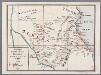
Zendingen der Witte Paters in Opper-Congoland : Maroengoe en Oeroealand
1 : 1000000 [S.l. : s.n.]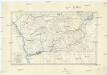
Croquis hypsométrique du Congo occidental
1 : 1000000 Kongo (Kinshasa) Delhaye, F. Sluys, M. E. Patesson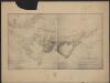
Carte du bassin du Niari (Loudima-Comba)
1 : 250000 Lamy, François 1858-1900 Paris : Aron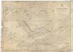
Afrika west coast
1 : 160000 Kongo (řeka) Vidal, R.N. Medlycott, Mervyn Bradford Admirality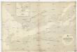
Afrika west coast
1 : 73000 Kongo (řeka) Medlycott, Mervyn Bradford Admirality
Provincia de Angola Porto de Luanda à Ponta das Palmeiras
1 : 60000 Hydrographic Map Instituto Hidrográfico Portugal Instituto Hidrográfico Portugal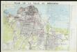
Plan de ville de Kinshasa

De baij en stadt Loand de St. Paulo geleegen aen de kust van Angola in Guinea
Angola Gerard van Keulen
Provincia de Angola Baía de Benguela
1 : 20000 Hydrographic Map Instituto Hidrográfico Portugal Instituto Hidrográfico Portugal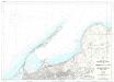
Provincia de Angola Porto de Luanda
1 : 15000 Hydrographic Map Instituto Hidrográfico Portugal Instituto Hidrográfico Portugal
Provincia de Angola Enseada do Quicombo
1 : 15000 Hydrographic Map Instituto Hidrográfico Portugal Instituto Hidrográfico Portugal
Provincia de Angola Porto do Lobito
1 : 10000 Hydrographic Map Instituto Hidrográfico Portugal Instituto Hidrográfico Portugal
Provincia de Angola Porto do Ambriz
1 : 10000 Hydrographic Map Instituto Hidrográfico Portugal Instituto Hidrográfico Portugal
Région du chemin de fer Congo-océan (esquisse topographique). Feuille 1 : Brazzaville-Kimbédi
1 : 250000 Lombard, Jean 1895-.... Paris : H. Barrère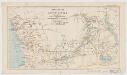
Map of a portion of South Africa : illustrative of Lieut. Cameron's route from lake Tangayika to the west coast
1 : 5000000 Ravenstein, Ernst Georg, 1834-1913 Geogr. Mag.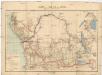
Carte du bassin du Congo
1 : 4000000 Kongo (Kinshasa) Kiepert, Richard Droysen, Wilhelm Dietrich Reimer
Carte du Congo Belge
1 : 4000000 Belgie Falk fils
Spezial-Karte von Afrika
1 : 4000000 Blatt 7 Habenicht, Hermann Perthes
Congo Belge
1 : 5000000 Kongo (Kinshasa) Institut cartographique militaire