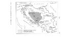
Maps of Dinaric Alps

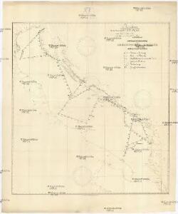
Reiseskizze der 12. Termifahrt S.M.S. Najade
Jaderské moře Cori, Carl J. K. u. k. Kriegsmarine
Skelettkarte des Adriatischen-Meeres für Kursskizzen
Jaderské moře K. u. k. Kriegsmarine
Le Golfe de Venise
1 : 400000 Mollova mapová sbírka Sanson, Guillaume Jaillot, Alexis Hubert
Le Golfe De Venise, Avec ses Principaux Caps. Promontoires, & Ports de Mer. [Karte], in: Atlas nouveau, contenant toutes les parties du monde [...], Bd. 2, S. 238.
1 Karte aus Atlas Sanson, Nicolas Jaillot, Alexis Hubert und Mortier, Pieter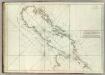
Carte De La Mer Mediterranee. VII.
Roux, Joseph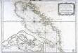
Carte hydrographique du golphe de Venise
1 Karte : Kupferdruck ; 58 x 85 cm Bellin s.n.
Karta o dubljinama Jadranskoga mora
Jaderské moře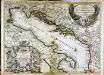
Le golfe de Venise
1 Karte : Kupferdruck ; 53 x 73 cm Sanson; Jaillot; Coronelli chez H. Jaillot
Charte von der Provintz Venedig und den oestereichischen Küstenlaendern Istrien und Dalmatien dann von dem Adriatischen Meere
1 : 1540000 Benátsko (Itálie) Liechtenstern, Joseph Marx von Hohlgartt, Ludwig Grafen von Kunst und Industrie Comptoirs
Adriatischer Dienst inclusive Corfu u. Prevesa
Jaderské moře-oblast
Das Adriatische Meer
Stieler's Hand-Atlas Stieler, Adolf bei Justus Perthes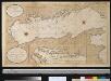
Nette afteekening van de Golf van Venetia vertoonende alle desselfs haavenen reede en baije in grood besteck
Italy Gerard van Keulen
[Das Adriatische Meer]
Hand-Atlas über alle Theile der Erde nach dem neuesten Zustande und über das Weltgebäude Stieler, Adolf bei Justus Perthes
Carte de geographie des differents etats de la republique de Venise, l'abregé de son gouvernement politique et ecclesiastique, et les etats ou elle a porté la gloire de ses armes
1 : 4300000 Benátky-oblast (Itálie) Chatelain, Henri-Abraham Chatelain
Le golfe de Venise
1 Karte : Kupferdruck ; 51 x 58 cm Fer; Starckman chez l'auteur dans l'isle du Palais sur le quay de l'Orloge a la Sphere Royale
Jugoslavia
1 : 2000000 Bartholomew. Firme [Edinburgh] : Edinburgh Geographical Institute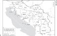
Die administrative Einteilung des Königreiches Jugoslawien nach Banschaften/banovine (ab 1929)
1 : 2500000 Jugoslawien Verwaltungsgliederung Clewing, Konrad ; John, Holger W.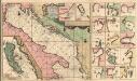
Pas-Caart-van de Weder zytsche Zee-kusten soo van Italia als Dalmatia en Griecken Inde Golff van Venetien
1 : 1400000 Mollova mapová sbírka Keulen, Gerard van Keulen, Gerard van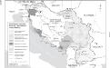
Besetzung und territoriale Aufteilung Jugoslawiens im Zweiten Weltkrieg
1 : 2500000 Jugoslawien Besetzung, Weltkrieg <1939-1945> Clewing, Konrad ; John, Holger W.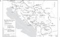
Staatenbildung im ehemaligen Jugoslawien, 1991 - 2008
1 : 2500000 Jugoslawien Auflösung, Staatenbildung Clewing, Konrad ; John, Holger W.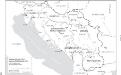
Jugoslawien nach dem Zweiten Weltkrieg (bis 1991) mit Republiken und Autonomen Provinzen
1 : 2500000 Jugoslawien Clewing, Konrad ; John, Holger W.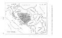
Politische Aufteilung des Königreichs Jugoslawien auf Banschaften 1929
Jugoslawien Verwaltungsgliederung Džambo, Jozo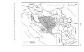
Politische Aufteilung des Königreichs SHS auf Gebiete (oblasti) 1922
Kraljevina Srba, Hrvata i Slovenaca Verwaltungsgliederung Džambo, Jozo
Partie Orientale De L'Italie qui comprend Les Royaumes De Naples Et De Sicile &c: [Karte] [südlicher Teil Siziliens] [Nebenkarte ], in: Atlas nouveau, contenant toutes les parties du monde [...], Bd. 2, S. 142.
1 Karte aus Atlas Sanson, Nicolas Jaillot, Alexis Hubert und Mortier, Pieter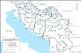
Eisenbahnnetz und Aufteilung der Adriaküste in Zonen (nach Vasković)
1 : 2500000 Jugoslawien Eisenbahnnetz Kežić, Danijel ; John, Holger W.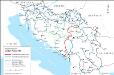
Eisenbahnnetz und Adria-Bahn-Projekte 1922
1 : 2500000 Jugoslawien Eisenbahnnetz Kežić, Danijel ; John, Holger W.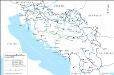
Das jugoslawische Eisenbahnnetz im Jahre 1918
1 : 2500000 Jugoslawien Eisenbahnnetz Kežić, Danijel ; John, Holger W.
Rajon dějstvīj russkago flota v vojnu s Francīej 1806-1807 gg. v Adrīatikě
Südeuropa Adria Seeschlacht
Das jugoslawische Eisenbahnnetz im Jahre 1969
1 : 2500000 Jugoslawien Eisenbahnnetz Kežić, Danijel ; John, Holger W.