Maps of Nordmalings kommun
Ostsee
1 : 200000 Baltské moře Reichs-Marine-Amt
Schema za-botničeskoj operacīi gr. Kamenskago 1809 g.
Finnland Kamenskij, Nikolaj Michajlowic Russisch-Schwedischer Krieg <1808-1809>
Plan boja pri d. Lappola (Nappo) 19 fevr. 1714 g.
Finnland Nordischer Krieg <1700-1721>
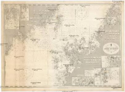
Ostsee
1 : 200000 Baltské moře Reichs-Marine-Amt
Trigonometrisk grunnlag, vedlegg 63a: Karta öfver Norra Sverige
1 : 500000 August Hahr Schlachter & Seedorff, Stockholm
Partie, Suede, Norwege. Europe 4.
1 : 1641836 Vandermaelen, Philippe, 1795-1869
Postkarte von Finnland und Norrland
Finsko jižní Ponheimer, Kilian im von Reillyschen Landkarten und Kunstwerke Verschleiss Komptoir
Karte von Finnland
1 : 2400000 Evropa Finland Steamship
NORDLANDIÆ | et quibies | GESTRICIA | et | HELSINGICÆ | REGIONES
Auct. Andrea Buræo Sueco. [Amsterdam : Joan Blaeu]
Island
Island Milbauer, Emanuel Vlastimil Walch, Johann
Schema raīona operacīi grafa Kamenskago
Finnland Kamenskij, Nikolaj Michajlowic Russisch-Schwedischer Krieg <1808-1809>
Nordlandiae et quibies Gestricia et Helsingicae regiones
1 : 1285000 auctore Andrea Buraeo Sueco [Amsterdam] : J. Blaeu
Die finnischen Seen
Finnland Seengebiet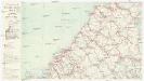
Finnland Straßenkarte
1 : 400000 Finsko Gen St d H Abt f Kr Kart u Verm W IV Mil Geo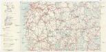
Finnland Straßenkarte
1 : 400000 Finsko Gen St d H Abt f Kr Kart u Verm W IV Mil Geo
Spesielle kart 18 Sør-øst: Telegrafkart over Norge
1 : 1000000 Den Private Opmaaling, Kristiania
Magni ducatus Finlandiae Russiae partim, partim Sueciae subjecti, sinus item Bothnici ac Finnici nova et accurata delineatio
1 : 1600000 Finsko Lotter, Tobias Conrad sumptibus Tobiae Conradi Lotter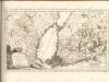

Magni Ducatus Finlandiae Russiae partim, partim Sueciae subjecti, sinus item Bothnici ac Finnici nova et accurata delineatio
1 : 1500000 [Augustae Vindelicorum] : calamo et sumptibus Matthaei Seutteri
MAGNVS DVCATVS | FINLANDIÆ
Auct. Andrea Buræo Sueco. [Amsterdam : Joan Blaeu]
Magnus Ducatus Finlandiae Nova et accurata delineatio. [Karte], in: Novus atlas absolutissimus, Bd. 1, S. 48.
1 Karte aus Atlas Janssonius Offizin
No.15. Karta Evropeyskaia Rossiia. Sheet 1
1 : 2000000 Shokalskago,Iu. M.
Das Grossfürstenthum Finland
1 : 2600000 Finsko Meissner, G. Benjamin Hermelin, S.G.
Distribution des dépôts quaternaires en Finlande
1 : 2000000 Sederholm, J.J. F. Tilgman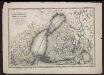
Voenno-dorožnaja karta časti Rossii i pograničnych zemelʹ
1 : 1680000 Schweden, Finnland Šubert [Generalmajor]
Feuille 11 (D II), uit: Carte géologique internationale de l'Europe : la carte, votée au congrès géologique international de Bologne en 1881, est exécutée conformément aux décisions d'une commission internationale, avec le concours des gouvernements, sous le dir. de M.M. Beyrich et Hauchecorne
Annotatie: Blad 48 gamme des couleurs; blad 49: bladwijzer en titelblad Heinrich Ernst Beyrich 1815-1896; Wi. Hauchecorne Berlin : Reimer / (Berlin: Institut lithographique)
[VIII], uit: Geognostische Karte des Oesterreichischen Kaiserstaates mit einem grossen Theile Deutschland's u. Italien / hauptsachlich nach ... Haidinger's geognostischer Karte dieses Staates bearb. von Josef Scheda
1 : 3000000 titelvariant: General-Karte von Europa in 25 Blättern; Annotatie: Bijlage bij: General-Karte von Europa in 25 Blättern. - 1:2.592.000. - 1845-1847 Scheda, Joseph Wien : K.K. Militär. Geografisch. Institut
Statistikk kart 6 sør: Norvége. Densité de la population en 1865
1 : 1000000
Finnländische Zuwanderer in St. Petersburg - Paßanträge vom Jahre 1820 in % der Bevölkerung
Finnland, St. Petersburg, Migration