Maps of Mizhhirya Raion

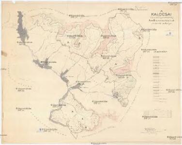
A Kalocsai m. kir. erdögondnokság A és B üzemosztályának átnézeti térképe
1 : 23000 Klösz Gy. és fia
Horinčovo
1 : 75000 Ukrajina Vojenský zeměpisný ústav
Okormezo (Galizien).
from Spezialkarte der osterreichisch-ungarischen Monarchie.
Berezna und Szinever.
from Spezialkarte der osterreichisch-ungarischen Monarchie.

Gorgany Zachodnie
1 : 100000 Lenkiewicz, Adam Książnica-Atlas
Zolkiew (Galizien).
from Spezialkarte der osterreichisch-ungarischen Monarchie.

Generalkarte von Zentraleuropa

Máramaros vármegye térképe
1 : 500000 Maramureş (Rumunsko) Kogutowicz, Manó Magyar Földrajzi Intézet
General-Karte des Königreiches Galizien und des Herzogthumes Bukovina
C. Marmarus
Rumänien Komitat Marmarosch
Comitat Marmaros
1 : 288000 Maramureş (Rumunsko)
Comitat Marmaros
1 : 280000 Marmarošská Sihoť (Rumunsko : oblast)
Generalkarte von Zentraleuropa
Neubertova generální automapa Republiky československé
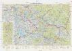
1 : 200000 Chust (Ukrajina) Soukup, Jan V. Neubert a synové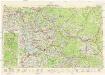
Neubertova generální automapa Republiky československé
1 : 200000 Chust (Ukrajina) Soukup, Jan V. Neubert a synové
Ukrainae pars quae Pokutia vulgo dicitur / per Guil. le Vasseur de Beauplan S. R. M. Poloniae archit
1 : 310000 1 Karte : Kupferdruck ; 42 x 51 cm Beauplan, Guillaume le Vasseur de [Verlag nicht ermittelbar]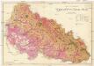
Podkarpatská Rus
1 : 225000 Podkarpatská Rus (Ukrajina) Gregor, František Novotný a Bartošek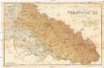
Podkarpatská Rus
1 : 225000 Podkarpatská Rus (Ukrajina) Gregor, František Novotný a Bartošek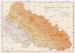
Podkarpatská Rus
1 : 225000 Podkarpatská Rus (Ukrajina) Gregor, František Novotný a Bartošek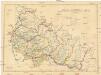
Podkarpatská Rus
1 : 300000 Podkarpatská Rus (Ukrajina) Referát min. veř. prací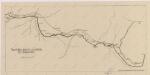
Sbírka map a diagramů použitých na mírových konferencích v Paříži v letech 1919 - 1920

Podkarpatská Rus
1 : 500000 Berehove (Ukrajina) Fastr Eduard
[Bukowina, Galizien]
1 Karte : Kupferdruck ; 18 x 13 cm [Trattner]
Podkarpatská Rus
1 : 300000 Berehove (Ukrajina) Fastr Eduard
Russia
Mollova mapová sbírka Hoffmann, Johannes Hoffmann, Johann
Ober Ungern
Rumunsko severní im Verlage des Kunst und Industrie Comptoirs
Ober Ungern
Rumunsko severní Ossenbrug, J. von Müller, Franz im Verlage des Kunst und Industrie Comptoirs