Maps of Salzburg

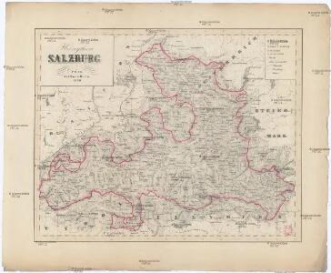
Herzogthum Salzburg
1 : 3200000 Salcburk (Rakousko : oblast) bei Marco Berra
Erz-Herzogthum Oesterreich, Land ob der Enns
1 : 360000 Salcburk-oblast (Rakousko) Renner A. Platt
Salzburg und Berchtesgaden
1 : 4000000 Berchtesgaden (Německo)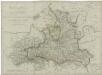
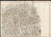
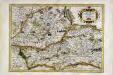
Herzogthum Salzburg

S. R. I. principat. et archiepiscopatus Salisburgensis mappa geographica delineatus in qua subjectae appertinent. finitimae regiones et ditiones accuratiss. ob oculos ponuntur
1 : 440000 Salcburk-oblast (Rakousko) Seutter, Matthäus studio Matth. Seutteri
General Carte vom Herzogthum Salzburg
1 : 291000 Salcburk-oblast (Rakousko)
General Carte vom Herzogthum Salzburg
1 : 291000 Salcburk-oblast (Rakousko) Withalm, Andreas
General Karte vom Herzogthum Salzburg
1 : 230000 Salcburk-oblast (Rakousko) Withalm, Andreas K. K. General-Quartiermeister-Staab
Das Chur=Fürstenthum Salzburg
1 Karte : Kupferdruck ; 49 x 48 cm Diewald bey den Homännischen Erben
Herzogthum Salzburg nach den besten und zuverlässigsten Hülfsmitteln verfasst
1 : 410000 Salcburk-oblast (Rakousko) Tranquillo Mollo
Neueste Karte von Salzburg
Grosser Hand-Atlas über alle Theile der Erde in 170 Karten Meyer, J. Verlag des Bibliographischen Instituts
Salzburg und Berchtesgaden
1 : 493000 Berchtesgaden (Německo) Jirasek, F. A. F.A. Jirasek
Saltzbvrg archiepiscopatvs, et Carinthia dvcatvs
1 Karte : Kupferdruck ; 36 x 48 cm Mercator; Janssonius apud Ioannem Ianssonium
Saltzbvrg archiepiscopatvs, et Carinthia dvcatvs
1 Karte : Kupferdruck ; 36 x 47 cm Mercator; Valck; Schenk apud G. Valk et P. Schenk
Spezial-Karte von Salzburg, Salzkammergut und einen Theil von Tyrol
1 : 320000 Salcbursko (Rakousko) Orlitsek, Fr. Vesco, Ciprian Ciprian Vesco's sel. Witw.
Spezial-karte von Salzburg, Salzkammergut und einen Theil von Tyrol
1 : 350000 Horní Rakousko (Rakousko) Orlitsek, Fr. Tritschlen, J. Ciprian Vesco's fel. Witw.
General-Karte von Salzburg
Lechner, R.
Sect. 27: München, uit: Geologische Karte des Deutschen Reichs in 27 Blaettern / [von] Richard Lepsius ; Red. von C. Vogel
1 : 500000 Annotatie: Blad 18 ontbreekt; Een aantal bladen op linnen; Een aantal bladen gereviseerd 1913-1914; Annotatie geografische gegevens: Met schaalstokken o.a. in kilometers; Legenda Carl Vogel 1828-1897 Gotha : Justus Perthes
Saltzbvrg archiepiscopatus cum ducatu Carinthiæ
1 Karte : Kupferdruck ; 32 x 46 cm Mercator; Hondius sumptibus Henrici Hondij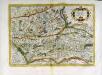
Saltzbvrg archiepiscopatus cum ducatu Carinthiæ
1 Karte : Kupferdruck ; 32 x 46 cm Mercator; Hondius sumptibus Henrici Hondij
Saltzbvrg archiepiscopatus cum ducatu Carinthiæ
1 Karte : Kupferdruck ; 32 x 45 cm Mercator s.n.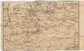
Salzburg - Nordsteirisch - Tiroler - Linie (Gisela Bahn)
Salcburk (Rakousko) K. k. Österreichische Staatsbahnen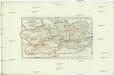
Das Herzoghtum Kaernten öestreichischen und salzburgischen Antheils
1 : 610000 Korutansko (Rakousko)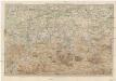
Karte der Salzburger-Alpen und des Salzkammerguts
1 : 250000 Salcburské Alpy (Rakousko : pohoří) Ravenstein, Ludwig L. Ravenstein
Tyrolis sub Felici Regimine Mariae Theresiae Rom. Imper. Avg. Chorographice Delineata ...
1 : 104000 Mollova mapová sbírka Mansfeld, Johann Ernst Mansfeld, Johann Ernest
Zell 158, uit: Special-Karte von Mittel-Europa / nach amtlichen Quellen bearbeitet von W. Liebenow
1 : 300000 titelvariant: W. Liebenow's Mittel-Europa; Annotatie: Titel boven de bladen: W. Liebenow's Mittel-Europa Johannes Wilhelm Liebenow 1822-1897 Frankfurt a. M. : Ludwig Ravenstein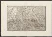
Militair Karte von Süd-Deutschland in 20 Sectionen
1 : 400000 15. Section Coulon, Alois von A. von Coulon
Carte topographique d'Allemagne contenant une partie de la Baviere, de l'eveché de Salzburg, de Tirol
1 Karte : Kupferdruck ; 46 x 63 cm Jaeger se vend chez l'auteur