Maps of Arctic Ocean
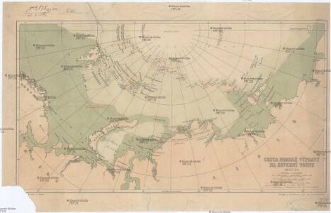
Cesta norské výpravy na severní točnu 1893-1896
1 : 12000000 Arktida nákladem J. Otty
Pascaart van de zee-custen van Ruslant, Laplant, Finmarcken, Spitsbergen en Nova-zemla
1 Karte : Kupferdruck ; 43 x 53 cm Doncker bÿ Hendrick Doncker inde Nieubrug steegh in't Stuurmans gereedtschap
Die nördliche und südliche Halbkugel der Erde
1 : 30000000 entworfen von C. F. Weiland Carl Metzeroth sc. Weimar : Verlag des Geograph. Instituts
Kaart der Noordelyke Yszee : volgens de waarnemingen van vroegere Nederlandsche zeelieden / [getekend door] R. van Wijk
Dordrecht : J. de Vos
Předběžná mapa cesty Framu podél severního pobřeží starého světa
1 : 5000000 Tajmyrský poloostrov (Rusko) nákladem J. Otty
Spesielle kart nr 117-3: Geistlig inndelingskart over Norge
1 : 1000
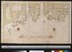
Nova Zembla, Waygats, Fretum Naßovicum, et Terra Samoiedum [...] [Karte], in: Het vijfde Deel Des Grooten Atlas : Vervatende De Water-Weereld, S. 126.
1 Karte aus Atlas Jansson, Jan Jansson, Jan
Partie de la mer glaciale contenant la Nouvelle Zemble et le pays des Samoiedes / par M.Bellin Ing.
1 : 5800000 1 Karte : Kupferdruck ; 19 x 32 cm Bellin, Jacques Nicolas Didot?]
Partie de la mer glaciale contenant la Nouvelle Zemble et le pays des Samoiedes / par M.Bellin Ing.
1 : 5800000 1 Karte : Kupferdruck ; 19 x 32 cm Bellin, Jacques Nicolas [Didot?]
NOVA ZEMLA.
[Amsterdam : Joan Blaeu]
La Nouvelle Zemble
1 : 9500000 1 Karte : Kupferdruck ; 23 x 39 cm Chez Pierre van der Aa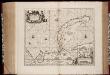
Nova Zemla : Waygats, Fretum Nassovicum, et Terra Samoiedum singula omnium emendatissimè descripta
1 : 2000000 Annotatie: Paskaart; Origineel is Blad 150 in atlas factice; Annotatie geografische gegevens: [Glijdende] schaalvermelding op kaart: 28 Milliaria Germanica, pro latitudinis gradu [66o-78o]=4,2-7,5 cm [Amstelodamum] : [Apud Ioannem Ianßonium]
Spesielle kart 83: Spitzbergen og Jan Mayen, Swedisch ekspedition
A. E. Nordenskiöld | N. Dunèr
Spitsberg. Europe 1 ter.
1 : 1641836 Vandermaelen, Philippe, 1795-1869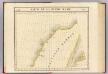
Partie, Russie d'Asie. Asie 1.
1 : 1641836 Vandermaelen, Philippe, 1795-1869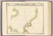
Partie, Russie d'Asie. Asie 2.
1 : 1641836 Vandermaelen, Philippe, 1795-1869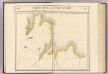
Partie, Russie d'Asie. Asie 3.
1 : 1641836 Vandermaelen, Philippe, 1795-1869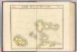
Partie, Russie d'Asie. Asie 4.
1 : 1641836 Vandermaelen, Philippe, 1795-1869
Kaart der Noordelyke Yszee volgens de waarnemingen van vroegere Nederlandsche zeelieden : de west kust van Nova Zembla, verbeterd naar de waarnemingen van de kapt. luit. Litke in 1823 ; behoorende tot de door het Provinciaal Utrechtsch Genootschap bekroonde verhandeling van R.G. Bennet en J. van Wyk Rz. ; R. van Wyk Jac.zn. del.
1 : 3000000 Te Dordrecht : by J. de Vos & Co.
54. Spitsbergen, Oslo, Stockholm, Copenhagen, Helsinki. The World Atlas.
1 : 250000 USSR (Union of Soviet Socialist Republics).
SPITSBERGA.
[Amsterdam : Joan Blaeu]
Spitsbergens kyst
1 : 100000 Arktida Hoel, Adolf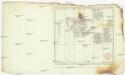
Neue Charte von Spitzbergen
Špicberky (Norsko) Martens, Friedrich
Spitsbergen / [getekend door] R. van Wijk
Dordrecht : J. de Vos
Baie Red
1 : 30000 Špicberky (Norsko) Albert Imprimerie Vieillemard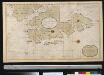
Nieuwe afteekening van het Westelijkste gedeelte van Spitsbergen
Svalbard Giles Gerard van Keulen
Předběžná mapa skupiny ostrovů, známé pod názvem Země Františka Josefa
1 : 5000000 arktická oblast Nansen, Fridtjof Jackson, Frederick George nákladem J. Otty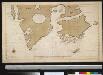
Afteekening van de zuijdzijde van het eijland Spits-Bergen int groodt
Svalbard Gerard van Keulen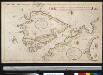
Het Noord Oosterland van het eijlandt Spits Bergen
Svalbard Giles Gerard van Keulen