Maps of Úsilné

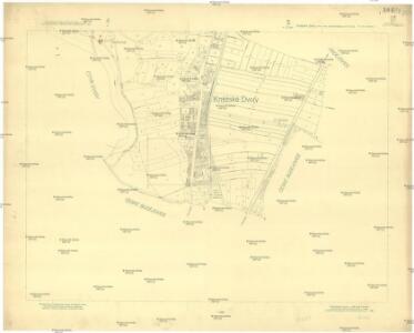
Kněžské Dvory, berní okres České Budějovice, země Česká
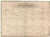
1 : 2880 Kněžské Dvory (České Budějovice, Česko) Reprodukční ústav Ministerstva financí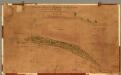
Project für den Bau einer Stützmauer und der Park : Anlage an der Budweisser Strasse Par
Projekt stavby opěrné zdi a parčíku pod skupinou budov, zvaných Hamburk, podél silnice do Českých Budějovic. U podpisů autorů datace s určením místa vzniku 'Karlsbad den 23. September 872'.
Pfaffenhöf - c3207-1-002 - Kaiserpflichtexemplar der Landkarten des stabilen Katasters
1 : 2880
Pfaffenhöf - c3207-1-001 - Kaiserpflichtexemplar der Landkarten des stabilen Katasters
1 : 2880
Hartowitz - c2344-1-006 - Kaiserpflichtexemplar der Landkarten des stabilen Katasters
1 : 2880
Hartowitz - c2344-1-005 - Kaiserpflichtexemplar der Landkarten des stabilen Katasters
1 : 2880
Hartowitz - c2344-1-002 - Kaiserpflichtexemplar der Landkarten des stabilen Katasters
1 : 2880
Hartowitz - c2344-1-003 - Kaiserpflichtexemplar der Landkarten des stabilen Katasters
1 : 2880
Hartowitz - c2344-1-001 - Kaiserpflichtexemplar der Landkarten des stabilen Katasters
1 : 2880
Hartowitz - c2344-1-004 - Kaiserpflichtexemplar der Landkarten des stabilen Katasters
1 : 2880
Nejnovější plán župního města Č. Budějovic
1 : 10000 České Budějovice (Česko) Lenc, F. Schinko, B. J. Svátek
[Gradkartenblatt]
1 : 25000 Hluboká nad Vltavou-oblast (Česko) Vojenský zeměpisný ústav

Vltava jižně od Prahy

Umgebung von Budweis
1 : 37000 České Budějovice-oblast (Česko) Popper, Filipp L.E. Hansen
Topographische Karte ... Herrschaft Krummau ...

Topographische Karte der in Böhmen budweiser Kreises liegenden
Uibersichts-Karte der hochfürstlich zu Schwarzenbergschen Domaine Frauenberg nach dem Stande im Jahre 1876
1 : 58000 Hluboká nad Vltavou-oblast (Česko) Danesch, Jos. Kreibich, František Jakub Jindřich
České Budějovice a okolí
1 : 75000 České Budějovice (Česko : oblast) Vojenský zeměpisný ústav
Třeboň
1 : 75000 Třeboň (Česko : oblast) Reichsamt für Landesaufnahme
Třeboň
1 : 75000 Třeboň-oblast (Česko) Vojenský zeměpisný ústav
Administrativ Karte der Hochfürstlich Schwarzenberg ́schen Herrschaft Frauenberg...
Plan der k.k. Chaussée und der im Bau bergriffenen Eisenbahn von Budweis bis zum Scheidungspunkte bei Leopoldschlag
1 : 73500 České Budějovice-Linec (železniční trať) Pilarski, V. Casimir Frühwirt, E. K. in der Kunsthandlung des H.F. Müller
Vltava

Podrobná mapa Království českého, Markrabství moravského a Vévodství slezského
1 : 100000 Kaplice (Český Krumlov, Česko : oblast) Srp, Jan Jos. R. Vilímek
Podrobná mapa Království českého
1 : 100000 Kaplice (Český Krumlov, Česko : oblast) Srp, Jan Jaroslav Bursík
Administrativ Karte der Hochfürstlich Schwarzenberg'schen Herrschaften Wittingau
1 : 57600 Třeboň-oblast (Česko) Stifter, Johann Falta, Josef Bzy und Forbes
Administrativní mapa třeboňského panství se statky Bzí a Borovany 1

Administrativní mapa třeboňského panství se statky Bzí a Borovany 1