Maps of gmina Kłobuck

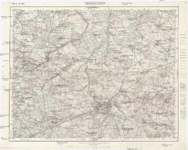
Tschensztochow
1 : 75000 Čenstochová-oblast (Polsko) K. u. k. Militärgeographisches Institut
Meßtischblatt 5279 : Ollschin, 1941
1 : 250000 Ollschin. - Aufn. 1881, hrsg. 1883, bericht. 1932, letzte Nachtr. 1932, gedr. [19]41. - 1:25000. - [Berlin]: Reichsamt für Landesaufnahme, 1941. - 1 Kt.
135. Lublinitz, uit: Topographische Uebersichtskarte des Deutschen Reiches / herausgegeben v. d. Kartogr. Abt. d. Königl. Preuß. Landesaufnahme
1 : 200000 titelvariant: Topogr. Übersichtskarte des Deutschen Reiches; Annotatie: Titel boven bladen ook: Topogr. Übersichtskarte des Deutschen Reiches; Annotatie geografische gegevens: Op elk blad twee maatstokken: 10 Kilometer = 5,5 cm; 1 geogr. Meile = 3,6 cm; Legenda onder op elk blad Königlich Preußische Landesaufnahme. Kartographische Abtheilung [S.l : Königlich Preußische Landesaufnahme, Kartographische Abtheilung]
Wielun 78, uit: Special-Karte von Mittel-Europa / nach amtlichen Quellen bearbeitet von W. Liebenow
1 : 300000 titelvariant: W. Liebenow's Mittel-Europa; Annotatie: Titel boven de bladen: W. Liebenow's Mittel-Europa Johannes Wilhelm Liebenow 1822-1897 Frankfurt a. M. : Ludwig Ravenstein
Beuthen 92, uit: Special-Karte von Mittel-Europa / nach amtlichen Quellen bearbeitet von W. Liebenow
1 : 300000 titelvariant: W. Liebenow's Mittel-Europa; Annotatie: Titel boven de bladen: W. Liebenow's Mittel-Europa Johannes Wilhelm Liebenow 1822-1897 Frankfurt a. M. : Ludwig Ravenstein

Kartographische Darstellung der Abstimmungs-Ergebnisse von Oberschlesien
1 : 100000 [im Auftrag des Auswärtigen Amtes bearb. in der Plankammer des Preußisch-Statistischen Landesamtes vom Gerke] ; mit Genehmigung der Landesaufnahme, Berlin Berlin : Berliner Lithographisches Institut
Mapa Górnego Śląska
1 : 600000 Horní Slezsko Gregor, Józef K. Miarka
Situations Plan der trokenen Landesgraenze zwischen dem Weichsel und Pietruvka Flus von kais. koen. Oesterreich. Schlesien und koen. Preussisch Schlesien
1 : 10000 Visla-oblast (Polsko) Kuffay, Franz Engel
Sect. 21: Breslau, uit: Geologische Karte des Deutschen Reichs in 27 Blaettern / [von] Richard Lepsius ; Red. von C. Vogel
1 : 500000 Annotatie: Blad 18 ontbreekt; Een aantal bladen op linnen; Een aantal bladen gereviseerd 1913-1914; Annotatie geografische gegevens: Met schaalstokken o.a. in kilometers; Legenda Carl Vogel 1828-1897 Gotha : Justus Perthes
Kolonie założone za panowania Fryderyka Wielkiego na Śląsku pruskim
Polen Schlesien Preußen Stadtgründung Friedrich II.
Novissima et accuratissima XVII Provinciarum Germaniae Inferioris Tabula
1 : 1500000 Mollova mapová sbírka Wit, Frederik de Deur, Abraham Janszoon Ottens, Josua
Novissima et accuratissima XVII Provinciarum Germaniae Inferioris Delineatio
1 : 1050000 Mollova mapová sbírka Schagen, Gerhardus Schagen, Gerhardus
Novissima et accuratissima XVII Provinciarum Germaniae Inferioris Delineatio
1 : 1500000 Mollova mapová sbírka Visscher, Nicolaes Deur, Abraham Janszoon Visscher, Nicolaus I.
Germaniae Inferioris XVII Provinciarum Accuratissima Tabula
1 : 1500000 Mollova mapová sbírka Visscher, Nicolaes Jansz. Deur, Abraham Janszoon Visscher, Nicolaus II.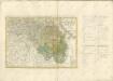

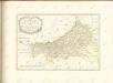
Silesiae dvcatvs
1 : 1050000 Mollova mapová sbírka Scultetus, Johannes Danckerts, Cornelis
Amplissimi Episcopatvs Wratislaviensis primum in suos IV Archidiaconatus deinde in Circulos Archipresbyteriales divisi Tabula Geographica :
1 : 730000 Mollova mapová sbírka Felbiger, Johann Ignaz Homann, Johann Baptista - dědici
Bez titulu: Přehledná mapa střední Evropy

Post und Eisenbahnkarte der Österreichisch-Ungarischen Monarchie

Strategische Übersichts-Karte des polnisch-litaurischen Armee-Bewegungraumes
Galizien, Karpathen, Bukowina nebst anschließendem Ungarn, Russland u. s. w.
Ravenstein, Hans
Karte der Provinz Schlesien
1 : 520000 Slezsko Handtke, Friedrich C. Flemming
Československá republika země Česká a Moravskoslezská
Kreise der Provinz Schlesien 1864
Preußen, Schlesien, Verwaltungsgliederung Kunz, Andreas ; Moeschl, Joachim Robert
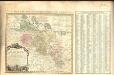
Strassen- und Eisenbahnkarte des oesterreichischen Kaiserthumes
1 : 864000 Blatt 3 Schaller, G. K.K. Militärisch-Geografisches Institut, Karten-Evidenthaltungs-Abteilung