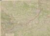
Maps of gmina Mniszków

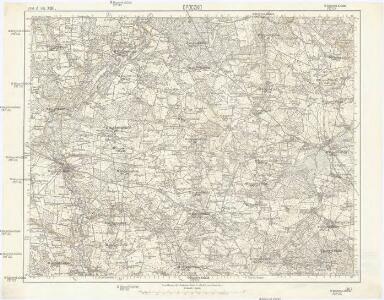
Opoczno
1 : 75000 Opoczno-oblast (Polsko) K. u. k. Militärgeographisches Institut
Kielce 79, uit: Special-Karte von Mittel-Europa / nach amtlichen Quellen bearbeitet von W. Liebenow
1 : 300000 titelvariant: W. Liebenow's Mittel-Europa; Annotatie: Titel boven de bladen: W. Liebenow's Mittel-Europa Johannes Wilhelm Liebenow 1822-1897 Frankfurt a. M. : Ludwig Ravenstein
Piotrkow
1 : 75000 Polsko K. u. k. Militärgeographisches Institut
West-Galizien
Halič (Polsko a Ukrajina) Metzburg, Georg Ignaz von im Verlage des Kunst und Industrie Comptoirs
Militair- Commerzial- und Post-Strassen von Dresden nach Warschau
Drážďany (Německo)
Militair- Commerzial- und Post-Strassen von Dresden nach Warschau
Drážďany (Německo)
Ost Galizien
Halič (Polsko a Ukrajina) Liesganig, Joseph m Verlage des Kunst- und Industrie- Comptoirs
Warschau, Lublin, Modlin (Nowogeorgiewsk)
1 : 750000 Lublin (Polsko : oblast) Karl, E. K. u. k. Militärgeographisches Institut
Warschau, Lublin, Nowo-Georgiewsk
1 : 750000 Lublin (Polsko : oblast) K. k. militär-geographisches Institut
Strategische Übersichts-Karte des polnisch-litaurischen Armee-Bewegungraumes
Galizien, Karpathen, Bukowina nebst anschließendem Ungarn, Russland u. s. w.
Ravenstein, Hans
General-Carte von Westgallizien
1 : 291000 Polsko jihovýchodní Benedicti, Lucas
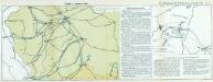
Nr. 13. Einfälle in Russisch-Polen
Polen Weltkrieg <1914-1918>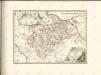

Zweite Offensive in Polen
1 : 4000000 Polen Feldzug, Weltkrieg <1914-1918>
Schlesien in nieder- und ober Schlesien, dann in Fürstenthümer eingetheilt, nebst der Grafschaft Glatz
1 : 1057000 Kladsko-oblast (Polsko) Mollo, Tranquillo T. Mollo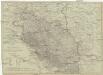
Schlesien in Nieder- und Ober Schlesien, dann in Fürstenthümer eingetheilt, nebst der Grafschaft Glatz
1 : 1057000 Kladsko-oblast (Polsko) Mollo, Tranquillo T. Mollo
[Polen]
1 : 800000 Polsko S. Hirzel
West-Galizien
1 : 850000 Halič (Polsko a Ukrajina) Metzburg, Georg Ignaz von Junker, Ch. T. Mollo und Comp.
Ducatus Silesiae Tabula
1 : 2800000 1 Karte : Kupferdruck ; 13 x 17 cm Weigel, Johann Christoph [Johann Christoph Weigel]
Mappa geographica exactissima continens Imperatoris Hæreditarium Dominium Silesiam, nec non eiusdem Provincias interiores Ducatus, Comitatus, Baronatus etc.
1 : 700000 edente Petro Schenck [Amsterdam] : edente Petro Schenck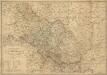
Das Herzogthum Schlesien in Nieder- und Oberschlesien dann in Fürstenthumer eingetheilt nebst der Grafschaft Glatz nach den besten und zuverlässigsten Hülfsmitteln verfasst im Jahr 1809
1 : 650000 Mollova mapová sbírka Mollo, Tranquillo Mollo, Tranquillo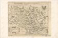
Abriss der Landschafft Schlesien, sampt den angrentzenden Königreichen und Landern


SILESIA | DVCATVS
A Martino Helwigio Nißense | descriptus. [Amsterdam : Joan Blaeu]
Silesia Ducatus
Das Oesterreichische-Kaiserthum

Silesia Ducatus [Karte], in: Le théâtre du monde, ou, Nouvel atlas contenant les chartes et descriptions de tous les païs de la terre, Bd. 1, S. 207.
1 Karte aus Atlas Blaeu, Willem Janszoon und Blaeu, Joan Blaeu, Willem Janszoon