Maps of Czech Republic

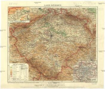
Land Böhmen
1 : 1000000 Most (Česko : oblast) Paul Sollors' Nachf.
Národnostní mapa Království českého
Čechy (Česko) Waraus, E. Wagner, Jan Eduard F. Kytka
Generální mappa [sic] Království českého
1 : 432000 Česko Kořistka, Karel František Edvard sklad Eduarda Hölzela
Geognostische Uibersichts-Karte der Kohlenführenden Formationen von Böhmen
Čechy (Česko) Hennig Verlag der J.G. Calve'schen Buchhandlung
Geognostische Uibersichts-Karte von Böhmen
Čechy (Česko) Hennig Verlag der J.G. Calve'schen Buchhandlung
Králowství České
1 : 1350000 Čechy (Česko) sklad Karla André
Králowství České
Česko Schlieben Ausfeld, Johann Carl sklad Karla André
Archäologische Karte des Königreiches Böhmen
Čechy (Česko) Schmitt, Anton Wagner, Jan Eduard Anton Schmitt
Archäologische Karte des Königreiches Böhmen
Čechy (Česko) Schmitt, Anton Wagner, Jan Eduard Anton Schmitt
Archäologische Karte des Königreiches Böhmen
Čechy (Česko) Schmitt, Anton Wagner, Jan Eduard Anton Schmitt
Historisch-geographisch-statistisch-gefaellsaemtliche KARTE vom Königreiche Böhmen
1 : 1040000 Česko Bastien, Joseph Mayregg, Cajetan von Cajetan von Mayregg
Historisch-geographisch-statistisch-gefaellsaemtliche Karte vom Königreiche Böhmen
1 : 1040000 Česko Bastien, Joseph Mayregg, Cajetan von Cajetan von Mayregg
Historisch-geographisch-statistisch-gefaellsaemtliche Karte vom Königreich Böhmen
1 : 1040000 Čechy (Česko) Bastien, Joseph Mayregg, Cajetan von Cajetan von Mayregg
Topographisch statistische Post und Strassenkarte des Königreiches Boehmen

Karten zur Statistik des Königreiches Böhmen...

Mapa jednot České obce sokolské v září 1889
Čechy (Česko) Podlipný
Mapa jednot České obce sokolské v září 1889
Čechy (Česko) Podlipný
Čechy
Čechy (Česko)
Das Kronland Böhmen
Čechy (Česko) Joseph Bermann
Reisekarte von Böhmen
1 : 600000 Bílina (Česko : oblast) Wagner, Jan Eduard F. Kytka
Karte des Königreiches Böhmen
1 : 430000 Čechy (Česko) Steinhauser, Anton Peucker, Karl Artaria
Neueste Handkarte von Böhmen
1 : 600000 Duchcov (Česko : oblast) Wagner, Jan Eduard F. Kytka
Mapa příruční Království českého
1 : 600000 Česko Kocen, Blaž Erben, Josef sklad Eduarda Hölzela
Mapa příruční Království českého
1 : 600000 Čechy (Česko) Kocen, Blaž Erben, Josef sklad Eduarda Hölzela
Mapa příruční Království českého
1 : 600000 Česko Kocen, Blaž Erben, Josef sklad Ed. Hölzela
Strassen- Uibersichts- und Militair-Routen-Karte des Königreichs Böhmen
1 : 580000 Česko Windisch-Graetz, Alfred Kandidus Marco Berra
Königreich Böhmen
1 : 1300000 Česko Carl André
Königreich Böhmen
1 : 1300000 Česko Carl Andre
Sprachenkarte von Böhmen
1 : 500000 Nová Bystřice-oblast (Česko) Rauchberg, Heinrich R. Lechner (Wilh. Müller)