Maps of Egypt

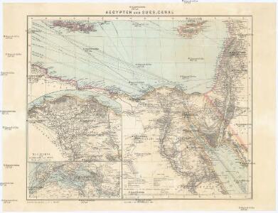
Aegypten und Sues-Canal
1 : 3500000 Egypt Justus Perthes
[Kaart], uit: Aegypten und Sues-Canal
1 : 3500000 titelvariant: Oorlogskaart; Egypte en Suez-kanaal; Annotatie: In omslag met titel: Oorlogskaart : Egypte en Suez-kanaal. - Amsterdam : Seyffardt, 1882; Annotatie geografische gegevens: Aangegeven zijn vaarroutes over de Middellandse Zee en de Rode Zee; Inzetkrt.: Nil-Delta und Landenge von Sues. - 1:1.500.000; [Noord-Afrika, West-Azië, Zuid-Europa] Gotha : Justus Perthes
Egypt a průplav Suezský
1 : 3700000 Egypt
Aegyptus et Arabia Petraea
1 : 1980000 Arabský poloostrov Reichard, Christian Gottlieb Campius, D. D. Campio
[XXIV], uit: Geognostische Karte des Oesterreichischen Kaiserstaates mit einem grossen Theile Deutschland's u. Italien / hauptsachlich nach ... Haidinger's geognostischer Karte dieses Staates bearb. von Josef Scheda
1 : 3000000 titelvariant: General-Karte von Europa in 25 Blättern; Annotatie: Bijlage bij: General-Karte von Europa in 25 Blättern. - 1:2.592.000. - 1845-1847 Scheda, Joseph Wien : K.K. Militär. Geografisch. Institut
Carte historique, physique & politique de l'Égypte
1 : 1210000 Alexandrie (Egypt) Lapie, Ch. Buckhardt chez Ch. Picquet
Deserta AEgypti, Thebaidis, Arabiae, Syriae, etc. ubi accurate notata sunt loca inhabitata per Sanctos Patres Anachoretas
Egypt Seutter, Matthäus Rogg, Gottfried Matth. Seutter
[Historisch-geographischer Atlas zu den allgemeinen Geschichtswerken von C. v. Rotteck, Pölitz u. Becker] : Aegypten und Canaan seit der frühesten Zeit bis auf Moses
von J. Loewenberg Lithographie von B. Herder in Freiburg im Breisgau [Freiburg im Breisgau] : [Herder]
Bez titulu: Historický Atlas

Feuille 47 (E VII), uit: Carte géologique internationale de l'Europe : la carte, votée au congrès géologique international de Bologne en 1881, est exécutée conformément aux décisions d'une commission internationale, avec le concours des gouvernements, sous le dir. de M.M. Beyrich et Hauchecorne
Annotatie: Blad 48 gamme des couleurs; blad 49: bladwijzer en titelblad Heinrich Ernst Beyrich 1815-1896; Wi. Hauchecorne Berlin : Reimer / (Berlin: Institut lithographique)
De kuste van Egipten en Barbaria beginnende van Jaffa tot I: Soliman int groot
Egypt Gerard van Keulen
Egypte ancienne, Palestine, Arabie Petree.
1 : 2300000 Brue, Adrien Hubert, 1786-1832
Egypt, Arabia, Palestine.
1 : 1940000 Robert Laurie & James Whittle
[Syrien, die Sinai-Halbinsel u. Aegypten]
Geographischer Atlas über alle Theile der Erde Ziegler, Jakob Melchior Verlag von Joh. Wurster um Comp.
Aegypten oder Misr
1 : 3710000 Egypt Schlieben Gleditsch
Das alte Aegypten
1 : 3871000 Egypt Schlieben Gleditsch
Egyptus Antiqua, ad Tempora Romana.
1 : 3100000 Vivien de St Martin, L.
Nile Delta and Sinai, Plate 86, V. IV
1 : 1250000 Bartholomew, John
Egypte ancienne, Palestine, Arabie Petree.
1 : 2300000 Picquet, C.
[Syrien, die Sinai-Halbinsel und Aegypten]
Geographischer Atlas über alle Theile der Erde Ziegler, Jakob Melchior Verlag von Dietrich Reimer
Map of Egypt
1 : 2000000 Alexandrie (Egypt) E. Stanford
[Unter Ägypten]
Egypt Brose, Wilhelm
Aegyptus et Palaestina
Schul-Atlas der alten Welt bei Justus Perthes
Aegyptus. (1826)
1 : 4400000 Tanner, Henry S.
Nova Ægypti tabula
1 : 3000000 Annotatie: Kaart van Noord-Egypte en de Rode Zee; Origineel is Blad 203 in atlas factice; Annotatie geografische gegevens: Vertikale schaalstok op kaart: 25 Milliaria Germanica (=6,3 cm); Oost boven [Amstelaedami] : [Labore & Sumptibus Ioannis Blaeu]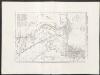
Egitto antico - Arabia petrea - Palestina secondo la ripartigione fra le 12 tribù degl'Israeliti
1 : 2400000 Marzolla, Benedetto [Verlag nicht ermittelbar]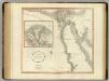
Egypt.
1 : 1950000 Cary, John, ca. 1754-1835
Syrien, Sinai u. Aegypten.
1 : 1600000 Ziegler, J. M.