Maps of Klosterneuburg

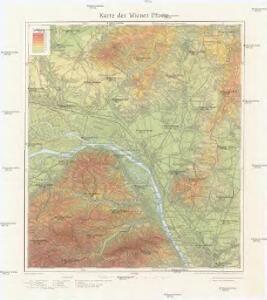
Karte der Wiener Pforte
1 : 50000 Vídeň (Rakousko : oblast) Kartogr. Inst.
Umgebung von Klosterneuburg
1 : 45000 Klosterneuburg (Rakousko)
Umgebung von Wien
Grundriß, von der Belägerung der Statt Kornneüburg, wie dieselbe den 22. May, von dem Herrn Gen: Felch Zeugmeister Herrn Grafen von Fluhaimb belägert vnd den 4. Aug: mit Aceord erobert worden Ao 1646
Mollova mapová sbírka Pironi, Franciscus Widemann, Elias
Handkarte des politischen Bezirkes Korneuburg
Uebersichts Karte des Wiener Donau Kanals und der Donau in Wiens Umgegend
1 : 28900 Dunaj Melczel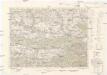
Tulln
1 : 75000 Kartographisches Institut
[6 Wien], uit: Geognostische Karte des Oesterreichischen Kaiserstaates mit einem grossen Theile Deutschland's u. Italien / hauptsachlich nach ... Haidinger's geognostischer Karte dieses Staates bearb. von Josef Scheda
1 : 3000000 titelvariant: General-Karte von Europa in 25 Blättern; Annotatie: Bijlage bij: General-Karte von Europa in 25 Blättern. - 1:2.592.000. - 1845-1847 Scheda, Joseph Wien : K.K. Militär. Geografisch. Institut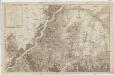
Neuester Grundriss der Haupt und Residenzstadt Wien und der umliegenden Gegenden
1 : 32400 Vídeň-oblast (Rakousko) Jakubicska, Stephan Mansfeld, Sebastian Artaria Compag.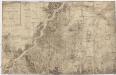
Neuester Grundriss der Haupt und Residenzstadt Wien und der umliegenden Gegenden
1 : 32400 Vídeň-oblast (Rakousko) Jakubicska, Stephan Mansfeld, Sebastian Artaria Compag.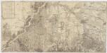
Neuester Grundriss der Haupt und Residenzstadt Wien und der umliegenden Gegenden
1 : 31000 Vídeň-oblast (Rakousko) Jakubicska, Stephan Mansfeld, Sebastian Artaria und Comp.
Freytag & Berndt's Ausflugskarte
1 : 100000 Vídeň (Rakousko : oblast) Kartogr. Anst. Freytag & Berndt
G. Freytag ́s Ausflugskarte
1 : 100000 Vídeň (Rakousko : oblast) Freytag, Gustav Freytag & Berndt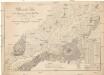
Übersichts Plan für die Preisfrage zur Erbauung einer Brücke über den Donaustrom in der Gegend bey Nussdorf
1 : 40000 Vídeň (Rakousko) Richard, Alb.
Pharus-Plan Wien
1 : 17000 Vídeň (Rakousko) Löwe, Cornelius Pharus-Verlag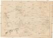
[Návrh mostu přes Dunaj v okolí Nussdorfu]
1 : 7000 Vídeň (Rakousko) Thomayr, A.
Plan der Gemeinde von Neuwaldek
Vídeň-oblast (Rakousko) Seyser, Carl
Wien s Umgebung

Typus Choro-Topographicus Caesareae Sedis Et Totius Germaniae Celeberrimae Urbis Viennae Austriacae
1 : 160000 Mollova mapová sbírka Seutter, Matthäus
TYPUS CHORO-TOPOGRAPHICUS CAESAREAE SEDIS ET TOTIUS GERMANIAE CELEBERRIMAE URBIS VIENNAE AUSTRIACAE, cum circum jacentis Territorii Oppidis, Coenobiis, Pagis, Villis
1 : 100000 Vídeň-oblast (Rakousko) Seutter, Matthäus per Matthaeum Seutter
Karte der Linie Wien-Znaim der oesterr. Nordwestbahn
1 : 350000 Vídeň-oblast (Rakousko) Lepař, Jan Raffelsperger, Franz artist. Anst. v. L.C. Zamarski
Karte der Umgebung von Wien
1 : 150000 Vídeň (Rakousko : oblast) Rothaug, Johann Georg G. Freytag & Berndt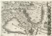
Archiducatus Austriae inferioris Geographica, et Nouiter Emendata Accuratissima Descriptio :
1 : 153333 Mollova mapová sbírka Vischer, Georg Matthaeus Hoffmann, Jakob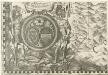
Austriacis Legio populis insignia prima Haec Romana dedit: quae Decus vsq; manent Altera Lupoldus dimicatis Virtute parauit Corpore clum, toto Sanguine tinctus erat
1 : 153333 Mollova mapová sbírka Vischer, Georg Matthaeus Hoffmann, Jakob
Chorographia VI. milliarium regionis circa urbem Viennam Austriacam
1 : 170000 Vídeň-oblast (Rakousko) Visscher, Nicolaes Jansz. per Homannianos Heredes
Wienns umgebungen

Blatt 6 & 11 aus Georg Matthäus Vischer's Archiducatus Austriae inferioris geographica, et noviter emendata accuratissima descriptio
1 : 144000 Rakousko Vischer, Georg Matthaeus K.k. Generalstabes
Unter Mannhartsberg
1 : 640000 Mollova mapová sbírka Insprugger, Sebastianus Voigt, Maria Theresia
Tulln.
from Spezialkarte der osterreichisch-ungarischen Monarchie.