Maps of Radeberg

Meinholds Karte der Dresdner Heide
1 : 20000 Drážďany (Německo : oblast) C. C. Meinhold & Söhne
Dresden und seine Vororte

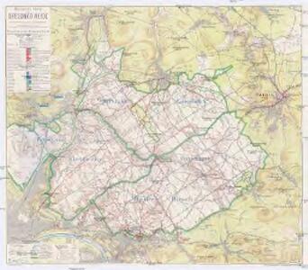
Meßtischblatt 4849 : Radeberg, 1943
1 : 250000 Radeberg. - Aufn. 1902, hrsg. 1904, bericht. 1933, letzte Nachtr. 1940, Ausg. 1942, gedr. 1943. - 1:25000. - Leipzig, 1943. - 1 Kt.
Meßtischblatt 51 : Radeberg, 1934
1 : 250000 Radeberg. - Umdr.-Ausg., aufgen. 1902, hrsg. 1904, bericht. 1920, Nachtr. 1926. - 1:25000. - Leipzig, 1934. - 1 Kt.
Meßtischblatt 51 : Radeberg, 1927
1 : 250000 Radeberg. - Umdr.-Ausg., aufgen. 1902, hrsg. 1904, bericht. 1920, Nachtr. 1926. - 1:25000. - Leipzig, 1927. - 1 Kt.
Meßtischblatt 51 : Radeberg, 1919
1 : 250000 Radeberg. - Aufgen. 1902, hrsg. 1904, einz. Nachtr. 1919. - 1:25000. - Leipzig, 1919. - 1 Kt.
Meßtischblatt 51 : Radeberg, 1916
1 : 250000 Radeberg. - Aufgen. 1902, hrsg. 1904, einz. Nachtr. 1916. - 1:25000. - Leipzig, 1916. - 1 Kt.
Meßtischblatt 51 : Radeberg, 1912
1 : 250000 Radeberg. - Aufgen. 1902, hrsg. 1904, einz. Nachtr. 1912. - 1:25000. - Leipzig, 1912. - 1 Kt.
Meßtischblatt Radeberg, 1910
1 : 250000 Radeberg. - Aufgen. 1902, hrsg. 1904, einz. Nachtr. 1910. - 1:25000. - Leipzig, 1910. - 1 Kt.
Meßtischblatt 67 : Pillnitz, 1920
1 : 250000 Pillnitz. - Umdr.-Ausg., aufgen. 1902, hrsg. 1905, kurrentgest. 1920. - 1:25000. - Leipzig: Giesecke & Devrient, 1920. - 1 Kt.
Meßtischblatt 67 : Pillnitz, 1919
1 : 250000 Pillnitz. - Aufgen. 1902, hrsg. 1905, einz. Nachtr. 1919. - 1:25000. - Leipzig, 1919. - 1 Kt.
Meßtischblatt 67 : Pillnitz, 1912
1 : 250000 Pillnitz. - Aufgen. 1902, hrsg. 1905, einz. Nachtr. 1912. - 1:25000. - Leipzig, 1912. - 1 Kt.
Meßtischblatt 67 : Pillnitz, 1908
1 : 250000 Pillnitz. - Aufgen. 1902, hrsg. 1905, einz. Nachtr. 1908. - 1:25000. - Leipzig, 1908. - 1 Kt.
Meßtischblatt 4848 : Klotzsche, 1944
1 : 250000 Klotzsche. - Aufn. 1909, hrsg. 1913, bericht. 1934, letzte Na. - 1:25000. - Leipzig, 1944. - 1 Kt.
Meßtischblatt 4848 : Klotzsche, 1937
1 : 250000 Klotzsche. - Umdr.-Ausg., aufgen. 1909, hrsg. 1913, bericht. 1934. - 1:25000. - Leipzig, 1937. - 1 Kt.
Meßtischblatt 50 : Eisenberg- Moritzburg, 1936
1 : 250000 Eisenberg- Moritzburg. - Umdr.-Ausg., aufgen. 1909, hrsg. 1913, bericht. 1920, einz. Nachtr. 1933. - 1:25000. - Leipzig, 1936. - 1 Kt.
Meßtischblatt 50 : Moritzburg, 1920
1 : 250000 Moritzburg. - Aufgen. 1909, hrsg. 1913, kurrentgest. 1920. - 1:25000. - Leipzig, 1920. - 1 Kt.
Pharus-Plan Dresden
1 : 11700 Pharus-Verlag Pharus-Verlag
Plan von Dresden mit den einverleibten Vororten
Reichel, Otto
Pharus-Plan Dresden
1 : 11700 Berlin : Pharus-Verlag [etc.]
Plan von Dresden
1 : 15000 Drážďany (Německo) C.C. Meinhold u. Söhne
Die Gegend der Haupt- und Residentz- Stadt dresden von drey Meil Weegs im Umcreyß
Mollova mapová sbírka Lidl, Johann Jakob Lidl, Johann Jacob
Die Gegend der Haupt- und Residentz- Stadt Dresden von drey Meil Weegs im Umcreyss
1 : 130000 Drážďany-oblast (Německo)
Position de toutes les armees et corps en Saxe le 19 et 20 Novbr [i.e. Novembre] 1759
1 : 165000 Drážďany-oblast (Německo) Werner, C. G.
Lobendau und Radeberg (Sachsen).
from Spezialkarte der osterreichisch-ungarischen Monarchie.
Topographische Reisekarte durch die umliegende Gegend von Dresden
1 : 200000 Drážďany-oblast (Německo) Lehmann, Johann Georg Arnoldischen Buch- und Kunsthandlung
Topographische Reisekarte durch die umliegende Gegend von Dresden
1 : 200000 Drážďany-oblast (Německo) Lehmann, Johann Georg Keyl, Carl Arnoldischen Buch- und Kunsthandlung
Topographische Reisekarte durch die umliegende Gegend von Dresden
1 : 200000 Drážďany-oblast (Německo) Lehmann, Johann Georg Keyl, Carl Arnoldischen Buch- und Kunsthandlung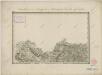
II. vojenské mapování 1a
1 : 144000