Maps of Yasinia

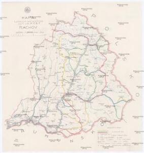
Mapa turistických cest značkovaných odb. K.Č.S.T. Rachov
1 : 200000 Československo Odbor klubu čsl. turistů
Rachov
1 : 75000 Ukrajina Vojenský zeměpisný ústav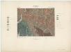
Zone 13, Kol. XXX, Gyertyánliget (Kabolapolyána), uit: [Geologische Specialkarte der im Reichsrathe vertretenen Königreiche und Länder der österreichisch-ungarischen Monarchie] / geologische Aufnahmen der königl. ung. Geologischen Anstalt
1 : 75000 Annotatie: Verantwoordelijkheidsvermelding in 1909 veranderd in: Königliche Ungarische Geologische Reichsanstalt; Sommige bladen in het Frans; Annotatie geografische gegevens: Coördinaten gebaseerd op nulmeridiaan van Ferro (Hierro) Königliche Ungarische Geologische Reichsanstalt; Königliche Ungarische Geologische Anstalt Budapest : [Königliche Ungarische Geologische Anstalt]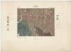
Kabola Polyana (Ungarn).; Spezialkarte der osterreichisch-ungarischen Monarchie.
from Spezialkarte der osterreichisch-ungarischen Monarchie. Austro-Hungarian Monarchy. Militärgeographisches Institut.,
III. vojenské mapování 4772
1 : 75000
Kabola Polyana
1 : 75000 Transkarpatien, Kobilecka Poljana Schrift und Gerippe v. Lieut. Schubert. Terrainschraffirung v. Oberlt. Borri
A Dombói m. kir. erdögondnokság "A" és "C" gazdasági osztályainak (tereselpatak) átnézeti térképe
1 : 23000 Klösz György és fia
Dubovo-Krasnišursky komposes. les

A Királymezöi m. kir. felsö erdögondnokság "A" és "B" gazdasági osztályainak átnézeti térképe
1 : 30000 Klösz György a syn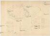
Přehledná mapa st. lesů lesní správy v Nižní Užčorné
1 : 23000
Řiditelství [sic] státních lesů Rachovo
1 : 75000 Voj. zeměpisný ústav
Brustury
1 : 75000 Ukrajina Vojenský zeměpisný ústav
Brusztura.
from Spezialkarte der osterreichisch-ungarischen Monarchie.
III. vojenské mapování 4773
1 : 75000
13 zóna, XXXI rovat, Bogdán Vidéke, uit: [Geologische Specialkarte der im Reichsrathe vertretenen Königreiche und Länder der österreichisch-ungarischen Monarchie] / geologische Aufnahmen der königl. ung. Geologischen Anstalt
1 : 75000 Annotatie: Verantwoordelijkheidsvermelding in 1909 veranderd in: Königliche Ungarische Geologische Reichsanstalt; Sommige bladen in het Frans; Annotatie geografische gegevens: Coördinaten gebaseerd op nulmeridiaan van Ferro (Hierro) Königliche Ungarische Geologische Reichsanstalt; Königliche Ungarische Geologische Anstalt Budapest : [Königliche Ungarische Geologische Anstalt]
Bogdán
1 : 75000 Bogdan Vodă, Marmarosch, Umland Schrift und Gerippe v. Assistent Leitner. Terrainschraffirung v. Lieut. R. Meschede
Bila Tisa
1 : 75000 Ukrajina Vojenský zeměpisný ústav
Bogdan.; Spezialkarte der osterreichisch-ungarischen Monarchie.
from Spezialkarte der osterreichisch-ungarischen Monarchie. Austro-Hungarian Monarchy. Militärgeographisches Institut.,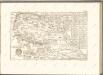

Generalkarte von Zentraleuropa

Máramaros vármegye térképe
1 : 500000 Maramureş (Rumunsko) Kogutowicz, Manó Magyar Földrajzi Intézet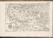
C. Marmarus
Rumänien Komitat Marmarosch
Comitat Marmaros
1 : 288000 Maramureş (Rumunsko)
Comitat Marmaros
1 : 280000 Marmarošská Sihoť (Rumunsko : oblast)
Generalkarte von Zentraleuropa

Gorgany Zachodnie
1 : 100000 Lenkiewicz, Adam Książnica-Atlas