Maps of Slovakia

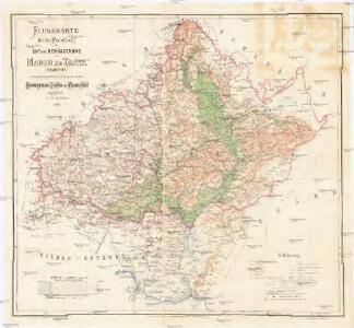
Flusskarte für die Projectirung der Ent- und Bewässerung der March und Thaya Gebiete
1 : 500000 Dolní Rakousko (Rakousko) Mannsfeld, Grafen Hieronymus, zu Edwards, Edward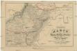
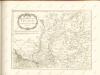
Uibersichts Karte der Eisen-Bahn-Route, zwischen Wien und Bochnia, nebst den Flügel-Bahnen
1 : 1150000 Bochnia (Polsko) H. Engel
Oesterreichisch-Ungarische Monarchie

Post Cours Karte für Mähren und Schlesien
Morava (Česko)
Conjuctio Danubij cum Oder vel per Moravam et Beczwam vel per Vagum, et Olsam
Mollova mapová sbírka Vogemont, Lothar
Markgrafschaft Mähren und Herzogthum Ober u. Nieder-Schlesien
1 : 1850000 Morava (Česko) Stieler, Adolf Mädel, Adolf Justus Perthes
Karte der Markgrafschaft Mähren mit Schlesien
1 : 875000 Morava (Česko) Raffelsperger, Franz Franz Raffelsperger
Karte der Markgrafschaft Mähren mit Schlesien
1 : 820000 Morava (Česko) Raffelsperger, Franz Franz Raffelsperger
Karte der Markgrafschaft Maehren mit Schlesien
1 : 875000 Morava (Česko) Rumpold, F. Franz Raffelsperger
Karte der Markgrafschaft Maehren mit Schlesien
1 : 875000 Morava (Česko) Raffelsperger, Franz Franz Raffelsperger
Národnostní mapa Republiky československé
Boháč, Antonín
Nástěnná mapa Československé republiky
Machát, František
Karte der Markgrafschaft Mähren mit Schlesien
1 : 860000 Morava (Česko) Raffelsperger, Franz Rumpold, F. Franz Raffelsperger
Blatt zur Übersicht der Special Karte der Markgrafschaft Mähren und des Herzogthums Schlesien
1 : 1000000 K.K. Militärisches Geographisches Institut
Wandkarte der Čechoslovakischen republik
Machát, František
Podrobný přehled politického rozdělení Slovenska
Vojenský zeměpisný ústav
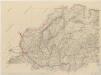
Die Kronländer Maehren und Schlesien
Morava (Česko) Marco Berra
Karte der Markgrafschaft Mähren mit Schlesien

Brünn, Troppau, Neutra
1 : 750000 Brno (Česko : oblast) Fendl, Jos. K. u. k. Militärgeographisches Institut
Brünn, Troppau, Neutra
1 : 750000 Brno (Česko : oblast) K. u. k. Militär-geographisches Institut
Brünn, Troppau, Neutra
1 : 750000 Brno (Česko : oblast) K. k. militär-geographisches Institut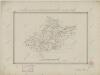
II. vojenské mapování Klad mapových listů
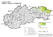
Slowakei 2001. Ruthenen (rusínska národnost’)
Slowakei ethnische Gruppe, Russinen Hofinger, Veronika
Politická mapa republiky Československé
Podrobný přehled politického rozdělení Slovenska

Übersichtskarte von Mittel - Europa

Bez titulu: Přehledná mapa střední Evropy

Orohydrographisches tableau aus der überschts-karte von Mittel -Europa