Maps of Rohrbach

Podrobná mapa Království českého
1 : 100000 Dolní Vltavice (Černá v Pošumaví, Česko) Srp, Jan Jaroslav Bursík
Hohenfurth und Rohrbach
1 : 75000 Vyšší Brod (Česko : oblast) Fischer K. u. k. militär-geographisches Institut
III. vojenské mapování 4552
1 : 75000
Hohenfurth und Rohrbach
1 : 75000 Vyšší Brod (Česko : oblast) K. u. k. Militärgeographisches Institut
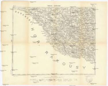
Vyšší Brod a Rohrbach
1 : 75000 Rakousko Vojenský zeměpisný ústav
Vyšší Brod a Rohrbach
1 : 75000 Rakousko Vojenský zeměpisný ústav
Mapy plánování ČSR

[Gradkartenblatt]
1 : 25000 Horní Rakousko (Rakousko) Kartographisches Institut

[Gradkartenblatt]
1 : 25000 Lipno (Česko : vodní nádrž : oblast) Kartographisches Institut
III. vojenské mapování 4552/1
1 : 25000
Topographische Karte der in Böhmen budweiser Kreises liegenden


Reiterschlag - c5640-2-012 - Kaiserpflichtexemplar der Landkarten des stabilen Katasters
1 : 2880
Reiterschlag - c5640-2-013 - Kaiserpflichtexemplar der Landkarten des stabilen Katasters
1 : 2880
Reiterschlag - c5640-2-008 - Kaiserpflichtexemplar der Landkarten des stabilen Katasters
1 : 2880
Reiterschlag - c5640-2-015 - Kaiserpflichtexemplar der Landkarten des stabilen Katasters
1 : 2880
Reiterschlag - c5640-2-007 - Kaiserpflichtexemplar der Landkarten des stabilen Katasters
1 : 2880
Reiterschlag - c5640-2-018 - Kaiserpflichtexemplar der Landkarten des stabilen Katasters
1 : 2880
Reiterschlag - c5640-2-010 - Kaiserpflichtexemplar der Landkarten des stabilen Katasters
1 : 2880
Reiterschlag - c5640-2-004 - Kaiserpflichtexemplar der Landkarten des stabilen Katasters
1 : 2880
Reiterschlag - c5640-2-002 - Kaiserpflichtexemplar der Landkarten des stabilen Katasters
1 : 2880
Reiterschlag - c5640-2-005 - Kaiserpflichtexemplar der Landkarten des stabilen Katasters
1 : 2880
Reiterschlag - c5640-2-020 - Kaiserpflichtexemplar der Landkarten des stabilen Katasters
1 : 2880
Reiterschlag - c5640-2-006 - Kaiserpflichtexemplar der Landkarten des stabilen Katasters
1 : 2880
Reiterschlag - c5640-2-016 - Kaiserpflichtexemplar der Landkarten des stabilen Katasters
1 : 2880
Reiterschlag - c5640-2-009 - Kaiserpflichtexemplar der Landkarten des stabilen Katasters
1 : 2880
Reiterschlag - c5640-2-001 - Kaiserpflichtexemplar der Landkarten des stabilen Katasters
1 : 2880
Reiterschlag - c5640-2-021 - Kaiserpflichtexemplar der Landkarten des stabilen Katasters
1 : 2880
Reiterschlag - c5640-2-019 - Kaiserpflichtexemplar der Landkarten des stabilen Katasters
1 : 2880
Reiterschlag - c5640-2-014 - Kaiserpflichtexemplar der Landkarten des stabilen Katasters
1 : 2880
Reiterschlag - c5640-2-017 - Kaiserpflichtexemplar der Landkarten des stabilen Katasters
1 : 2880
Reiterschlag - c5640-2-003 - Kaiserpflichtexemplar der Landkarten des stabilen Katasters
1 : 2880