Maps of Netherlands

Bladwijzer van de kaarten op de schaal van 1:25 000, 1:50 000 en 1:200 000
1 : 600000 Nizozemsko Topogr. Inrichting
Karte der itzo vereinigten Niederlande
1 : 990000 Nizozemsko
Holland.
1 : 1290000 Finley, Anthony
Holland.
1 : 1048000 Hughes, William
Charte der Hollaendischen départemens
Nizozemsko Kipferling, Karl Joseph Krayenhoff, Cornelius Rudolphus Theodorus J. Riedl's Kunsthandung
Charte der Hollaendischen départemens
Nizozemsko Krayenhoff, Cornelius Rudolphus Theodorus Verlage des Kunst und Industrie
Proef eener geologische kaart van de Nederlanden
1 : 800000 door W.C.H. Staring op steen geteekend en gegraveerd door J.Jaeger. Groningen : J. Oomkens Jz
Pays-Bas.
1 : 700000 Vivien St Martin, L.
Seven United Provinces.
1 : 1460000 Bowen, Frances
[Nizozemsko]
Nizozemsko Bilderdyk, W Veelwaard, D.
Grande carte routiere de la Hollande
1 : 400000 Nizozemsko Cartes Taride
Seven United Provinces.
1 : 950000 Playfair, Principal
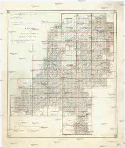
Overzichtskaart van den Topographischen atlas van het Koningrijk der Nederlanden op de schaal van 1:200.000
1 : 1000000 titelvariant: Bladwijzer van den Topographischen atlas van het Koninkrijk der Nederlanden op de schaal van 1:200.000; Topographische atlas van het Koningrijk der Nederlanden op de schaal van 1:200.000; Annotatie: Omslagtitel: Bladwijzer van den Topographischen atlas van het Koninkrijk der Nederlanden op de schaal van 1:200.000 ['s-Gravenhage : Topographische Inrichting]
Comitatus Hollandiae denuo forma leonis
1 : 570000 Alkmaar (Nizozemnsko) Visscher, Claes Jansz. Nassau-Usingen, Karel van a Nicolao Iohannis Visscher
Netherlands.
1 : 1290000 Hughes, William
Belgica foederata complectens septem provincias, ducatum Geldriae, comitatus Hollandiae et Zeelandiae dioec. traject. transisul. Groningam et Frisiam et circumjacentes provincias mappa geographica
1 : 610000 Belgie Lotter, Tobias Conrad per Tobia[m] Conr. Lotter
Belgica foederata complectens septem provincias, ducatum Geldriae, comitatus Hollandiae et Zeelandiae dioec. traject. transisul. Groningam et Frisiam et circumjacentes provincias mappa geographica
1 : 610000 Belgie Lotter, Tobias Conrad Lotter, Matthäus Albrecht per Tobia[m] Conr. Lotter
Foederatae Belgicae tabvla
1 : 728000 Limburg (Belgie) Wit, Frederick de F. de Wit
Belgium Foederatum
1 : 620000 Mollova mapová sbírka Danckerts, Justus Danckerts, Justus
Belgium Foederatum
1 : 630000 Mollova mapová sbírka Wit, Frederik de Covens, Johannes I

Kaart van Nederland, aanwijzende de oude bewoners en plaatsen, verdeeling in gouwen, waar Germaansche en Romeinsche oudheden gevonden zijn enz. / [G.A. Stratingh] ; lith. Atel. v. J. Jaeger
1 : 520000 titelvariant: Aloude staat en geschiedenis des vaderlands; Annotatie geografische gegevens: Schaalstokken; Legenda Gozewinus Acker Stratingh 1804-1876; Carl Friedrich Julius Jaeger 1815- Groningen : bij R.J. Schierbeek / (Groningen : Atel. v. J. Jaeger)
Kaart der bosschen in Nederland / bewerkt door H. Blink ; uitgegeven door de afdeeling Amsterdam der Nederlandsche Heidemaatschappij, met subsidie van het hoofdbestuur
1 : 400000 Annotatie: Met lijst: Gemeenten, waar de uitgestrektheid der bosschen 20 en meer procent van de oppervlakte bedraagt; Annotatie geografische gegevens: Legenda Hendrik Blink 1852-1931; Nederlandsche Heidemaatschappij. Afdeeling Amsterdam [Amsterdam : Afdeeling Amsterdam der Nederlandsche Heidemaatschappij] / ('s-Hage : lithographie en kleurendruk van J. Smulders & C°.)
Seven United Provinces.
1 : 510000 Faden, William, 1750?-1836
Holland.
1 : 1300000 Darton, William
Septem provinciae Belgivm foederatvm
1 : 603000 Nizozemsko Mayer, Tobias Hom[m]anianis Heredibus
Septem provinciae Belgivm foederatvm
1 : 600000 Belgie Mayer, Tobias Musschenbroek, Petrus van Hom[m]anianis Heredibus
Septem provinciae seu Belgivm foederatvm
1 : 600000 Belgie Mayer, Tobias Musschenbroek, Petrus van edentibus Homan[n]ianis Heredibus
Kaart der woeste gronden in Nederland / bewerkt door H. Blink ; uitgegeven door de afdeeling Amsterdam der Nederlandsche Heidemaatschappij, met subsidie van het hoofdbestuur
1 : 400000 Annotatie: Verkrijgbaar bij H. Gerlings te Amsterdam; Met lijst: Gemeenten, waar de uitgestrektheid der woeste gronden 30 en meer procent van de totale oppervlakte bedraagt; Annotatie geografische gegevens: Legenda Hendrik Blink 1852-1931; Nederlandsche Heidemaatschappij. Afdeeling Amsterdam [Amsterdam : Afdeeling Amsterdam der Nederlandsche Heidemaatschappij] / ('s-Gravenhage : lithographie en kleurendruk van J. Smulders & C°.)