Maps of Switzerland
Carte routiere de la Suisse
1 : 400000 Švýcarsko Société Suisse du numérotage des routes
Touristenkarte der Schweiz
1 : 650000 Evropa Publizitätsdienst der Schweizer. Bundesbahnen
Die Schweizer Alpenpässe
La Suisse.
1 : 900000 Bonne, Rigobert, 1727-1794
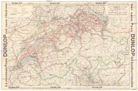
Carte signalant les dispositions spéciales qui régissent la circulation des automobiles en Suisse
1 : 750000 Švýcarsko Polizeiabteilung des Eidgenössischen Justitz- & Polizeidepartements
Touristenkarte der Schweiz
1 : 450000 Evropa Publizitätsdienst der Schweiz. Bundesbahnen
Suisse
1 : 450000 Evropa Service de publicité des Chemins de fer fédéraux
Carte générale de la Suisse suivant les nouvelles divisions, qui comprennent les ci-devant XIII cantons, leurs alliés et sujets, et forment actuellement la république helvétique une et invisible
1 : 525000 Mechel, Christian von Chrétien de Mechel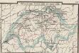
Helvetiorum foedus inde ab 1513
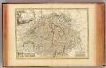
Schweiz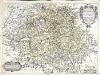
Charte de la Svisse, de la Rhetie, ov des Grisons, de la Valteline, dv Valay, [et] autres seigneuries voisines
1 Karte : Kupferdruck ; 38 x 51 cm Tavernier; Baudoin chez Melchior Tauernier demeurant en lisle du Palais sur le quaÿ qui regarde la Megiserie
Carte de Suisse ou sont les treizes cantons, leurs alliés et leurs sujets
1 Karte dressée, rectifiée et augmentée sur les observations faites sur les lieux par Abr. Rouvier ; T. Kitchin sculp. ; revised and improved by Iohn Rocque [Carington Bowles], [London]

Karte von der Schweiz
1 : 500000 1 Karte Fuessli & Comp., Zürich
Nieuwe kaart van Zwitserland
1 : 700000 1 Karte by Jsaak Tirion, Amsterdam
<<A>> map of Switzerland, comprehending the thirteen cantons with their allies and their subjects
1 Karte by [John] Roberts Sayer No 55 Fleet Street, [London]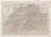
Der Schweiz
1 : 600000 Švýcarsko Gräf, Carl Geographisches Institut
Schirmhäuser des Schweizerischen Alpenclubs
1 : 800000 Wurster, Randegger & Co.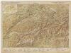
[Kaart], uit: Carte scolaire de la Suisse = Schulkarte der Schweiz / H. Kümmerly
1 : 600000 titelvariant: Schulkarte der Schwei; Annotatie: Op omslag (verso): statische gegevens; Annotatie geografische gegevens: Inzet: Politische Übersicht = Carte politique = Carta politica. - Schaal 1:2.750.000 H. Kümmerly Bern : Kümmerly & Frey
Landkort over republiquen Schweitz
1 : 1900000 1 Karte udgivet og bekostet af N. Jonge [Verlag nicht ermittelbar], [Danmark]

Die Schweiz auch Fürstenthum Liechtenstein
Schul-Atlas über alle Theile der Erde nach dem neuesten Zustande, und über das Weltgebäude Stieler, Adolf bei Justus Perthes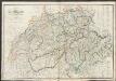
Switzerland
A new general atlas of modern geography, consisting of a complete collection of maps of the four quarters of the globe Wyld, James James Wyld
Die Schweiz.
1 : 870000 Radefeld, Carl Christian Franz, 1788-1874
<<La>> Suisse qui comprend les XIII cantons, leurs sujets et leurs alliéz
1 Karte dressée sur la communication de plusieurs cartes manuscrites, et assujétie aux observations de l'Académie R.lle. chéz V.e Daudet et Joubert, Lyon
Helvetia divisia in tredecim cantones, sive regiones, Bernam nempe, Friburgum, Solodurum, Basileam, Schafhusian, Tigurum et Lucernam, cum foederatis regionibus, numirum comitatu Neoburgensi, urbe Biela, resp. Genevensi, abbatia S.Galleni et Vallesia
1 Karte curantibus Gerarde et Leonardo Valk Gerarde et Leonardo Valk, [Amsterdam]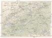
Schweiz
1 : 900000 Interlaken (Švýcarsko) Kümmerly & Frey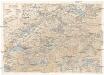
Schweiz Touristenkarte
1 : 900000 Interlaken (Švýcarsko) Gebr. Fretz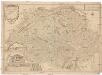
Les Suisses leurs sujets et leurs alliez
1 : 500000 Švýcarsko Fer, Nicolas de Dant Dant
La Suisse
1 Karte : Kupferdruck ; 46 x 63 cm Bonne; Lattré chés Lattré grav.r ord. de Mons.gr le Dauphin ruë S. Jacques à la ville de Bordeaux