Maps of Lesachtal

Luggau
1 : 25000 Kartographisches Institut
Zone 19, Col. VII, Sillian und St.Stefano del Comelico, uit: Geologische Karte der im Reichsrathe vertretenen Königreiche und Länder der Österreich-Ungarischen Monarchie : auf Grundlage der Specialkarte i.M. 1:75.000 des k.u.k. Militär-geographischen Institutes / neu bearb. und als Kartenwerk von 341 Blattnummern in zwanglosen Lfg. hrsg. durch die k.k. Geologische Reichsanstalt in Wien
1 : 75000 titelvariant: Geologische Spezialkarte der im Reichsrate vertretenen Königreiche und Länder der Österreichisch-Ungarischen Monarchie; Geologische Specialkarte der im Reichsrathe vertretenen Königreiche und Länder der Österreichisch-Ungarischen Monarchie; Annotatie: Titel bovenaan kaartblad: Geologische Spezialkarte der im Reichsrate vertretenen Königreiche und Länder der Österreichisch-Ungarischen Monarchie en Geologische Specialkarte der im Reichsrathe vertretenen Königreiche und Länder der Österreichisch-Ungarischen Monarchie; Annotatie geografische gegevens: Coördinaten gebaseerd op nulmeridiaan van Ferro (Hierro) Kaiserlich-Königliche Geologische Reichsanstalt, Wenen Wien : K.K. Geologische Reichsanstalt
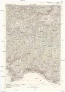
Sillian und S. Stefano di Cadore
1 : 75000 Kartographisches, früher Militärgeographisches Institut
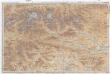
St. Jakob im Lesachtale
1 : 25000 Kartographisches Institut
Sillian und St.Stefano Di Cadore.
from Spezialkarte der osterreichisch-ungarischen Monarchie.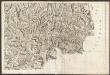
Carte du Tyrol
1 : 150000 Ost-Blatt Anich, Peter par le Dépôt Général de la Guerre
Il Cadorino [Karte], in: Novus atlas absolutissimus, Bd. 5, S. 33.
1 Karte aus Atlas Janssonius Offizin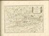

Il Cadorino [Karte], in: Theatrum orbis terrarum, sive, Atlas novus, Bd. 3, S. 125.
1 Karte aus Atlas Blaeu, Joan Blaeu, Willem Janszoon
IL CADORINO.
[Amsterdam : Joan Blaeu]
Il Cadorino [Karte], in: Le théâtre du monde, ou, Nouvel atlas contenant les chartes et descriptions de tous les païs de la terre, Bd. 3, S. 147.
1 Karte aus Atlas Blaeu, Willem Janszoon und Blaeu, Joan Blaeu, Willem Janszoon
Il Cadorino [Karte], in: Novus Atlas, das ist, Weltbeschreibung, Bd. 3, S. 145.
1 Karte aus Atlas Blaeu, Joan Blaeu, Willem Janszoon
Plan der Bergwerg, Stain, und Schwamburg
Mollova mapová sbírka Geyer
Plan der Bergwergs Schwarz Rappen, in der Gosniz
Mollova mapová sbírka Geyer
Plan deren Gebirgen Sent-Kopf, und Wurtzkopf
Mollova mapová sbírka Geyer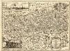
Novissima Carinthiae Tabula
1 : 260000 Mollova mapová sbírka Zauchenberg, Johann Baptist Zeuchenberg, Johann Baptist
Ducatus Carinthiae Tabula
1 : 740000 Mollova mapová sbírka Engelbrecht, Martin Engelbrecht, Martin
Ducatus Carinthiae Tabula
1 : 740000 Mollova mapová sbírka Engelbrecht, Martin Engelbrecht, Martin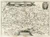
Ertzhertzogthum Kärnten
1 : 600000 Mollova mapová sbírka Valvasor, Janez Vajkard Endter, Wolfgang Moritz
Carinthiae Ducatvs Hertzogthum Cärnten
1 : 560000 Mollova mapová sbírka Merian, Matthaeus Merian, Matthäus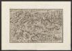
Militair Karte von Süd-Deutschland in 20 Sectionen
1 : 400000 19. Section Coulon, Alois von A. von Coulon
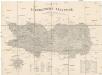
Oberkaernten oder der Villacher Kreis
1 : 250000 Korutansko (Rakousko) Kindermann, Joseph Karl Junker, Christoph Franz Xaver Miller
Oberkaernten oder der Villacher Kreis
1 : 250000 Korutansko (Rakousko) Kindermann, Joseph Karl Junker, Christoph Franz Xaver Miller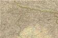
Carta d ́Italia speciale per Automobilisti
Karte des Herzogthums Kaernten
1 : 232000 Klagenfurt (Rakousko : oblast) Bayer, Michael Ferdinand v. Kleinmayr
Drahtseilbahn Cortina-Belvedere
Cortina d'Ampezzo (Itálie) A. Dandrea
Carta Generale del Regno Lombardo-Veneto e paesi limitrofi... II.
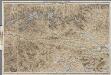
[Kaart], uit: Karte der Ost-Tiroler Alpen, Tauern und Dolomiten / von Ludwig Ravenstein
1 : 250000 Ravenstein, Ludwig Frankfurt am Main : Ravenstein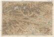
Karte der Ost-Tiroler Alpen, Tauern und Dolomiten
1 : 250000 Dolomity (Itálie) Ravenstein, Ludwig Ludwig Ravenstein