Maps of Selfoss

Carte internationale du monde au 1:1,000,000 E
1 : 1000000 Generalstabens topografiske Afdeling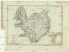
Charte von Island und den Färöer Inseln
1 : 1400000 Faerské ostrovy
CHARTE von ISLAND und den Färöer Inseln
1 : 1420000 Faerské ostrovy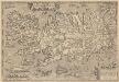
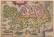
Islandia. [Karte], in: Theatrum orbis terrarum, S. 384.
1 Karte aus Atlas Ortelius, Abraham Vrients, Jan Baptista
Tabula Islandiae Auctore Georgio Carolo Flandro. [Karte], in: Theatrum orbis terrarum, sive, Atlas novus, Bd. 1, S. 39.
1 Karte aus Atlas Blaeu, Joan Blaeu, Willem Janszoon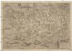
Islandia
1 : 2046000 Island Velleius, Andreas Frederik A. Ortel.
Feuille 8 (A II), uit: Carte géologique internationale de l'Europe : la carte, votée au congrès géologique international de Bologne en 1881, est exécutée conformément aux décisions d'une commission internationale, avec le concours des gouvernements, sous le dir. de M.M. Beyrich et Hauchecorne
Annotatie: Blad 48 gamme des couleurs; blad 49: bladwijzer en titelblad Heinrich Ernst Beyrich 1815-1896; Wi. Hauchecorne Berlin : Reimer / (Berlin: Institut lithographique)
Carte reduite de l'isle d'Antigue : dressée au Dépost des cartes, plans et journaux de la marine : pour le service des vaisseaux du roy : par ordre de M. le Marquis de Massiac, lieutenant général des Armeés navales, Secretaire d'Etat aiant le Département de la marine
1 : 92500 Bellin, Jacques Nicolas, 1703-1772 Dépost des cartes, plans et journaux de la marine
Carte generale de toute l'Europe, 1
1 Blatt : 57 x 48 cm J.M. Will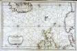
Carte réduite de partie de la mer du Nord comprise entre l'Ecosse, le Dannemark, la Norwege et l'Islande
1 Karte : Kupferdruck ; 55 x 83 cm Bellin s.n.
Feuille 9 (B II), uit: Carte géologique internationale de l'Europe : la carte, votée au congrès géologique international de Bologne en 1881, est exécutée conformément aux décisions d'une commission internationale, avec le concours des gouvernements, sous le dir. de M.M. Beyrich et Hauchecorne
Annotatie: Blad 48 gamme des couleurs; blad 49: bladwijzer en titelblad Heinrich Ernst Beyrich 1815-1896; Wi. Hauchecorne Berlin : Reimer / (Berlin: Institut lithographique)
Old Greenland.
1 : 9850000 Bowen, Emanuel
[II], uit: Geognostische Karte des Oesterreichischen Kaiserstaates mit einem grossen Theile Deutschland's u. Italien / hauptsachlich nach ... Haidinger's geognostischer Karte dieses Staates bearb. von Josef Scheda
1 : 3000000 titelvariant: General-Karte von Europa in 25 Blättern; Annotatie: Bijlage bij: General-Karte von Europa in 25 Blättern. - 1:2.592.000. - 1845-1847 Scheda, Joseph Wien : K.K. Militär. Geografisch. Institut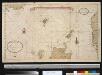
Het Noorder deel van de Noord Zee seer dienstig voor de Oostindise kruijsers
North Sea Gerard van Keulen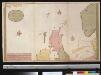
Nieuwe paskaert vant Noorderdeel der Noord Zee als meede een gedeelte van de West cust van Schotlant en Irland seer dienstigh voor de kruijsers op de Oostindise scheepen
Scotland Gerard van Keulen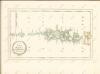
Islandia. [Karte], in: Theatrum orbis terrarum, S. 290.
1 Karte aus Atlas Ortelius, Abraham
Islandia. [Karte], in: Atlas, sive, Cosmographicae meditationes de fabrica mundi et fabricati figura, S. 77.
1 Karte aus Atlas Mercator, Gerhard
Tabula Islandiae [Karte], in: Le théâtre du monde, ou, Nouvel atlas contenant les chartes et descriptions de tous les païs de la terre, Bd. 1, S. 41.
1 Karte aus Atlas Blaeu, Willem Janszoon und Blaeu, Joan Blaeu, Willem Janszoon
Tabula Islandiae [Karte], in: Gerardi Mercatoris et I. Hondii Newer Atlas, oder, Grosses Weltbuch, Bd. 1, S. 45.
1 Karte aus Atlas Mercator, Gerhard und Hondius, Jodocus Jansson, Jan
Tabula Islandiae [Karte], in: Novus Atlas, das ist, Weltbeschreibung, Bd. 1, S. 25.
1 Karte aus Atlas Blaeu, Joan Blaeu, Willem Janszoon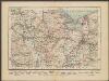
Islandia. [Karte], in: Gerardi Mercatoris Atlas, sive, Cosmographicae meditationes de fabrica mundi et fabricati figura, S. 79.
1 Karte aus Atlas Mercator, Gerhard Montanus, Petrus
Tabula Islandiae [Karte], in: Novus atlas absolutissimus, Bd. 1, S. 164.
1 Karte aus Atlas Janssonius Offizin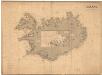
Museumskart 192: Iceland
J. W. Appleton Norie & Wilson
Danish Islands in the North Atlantic Ocean.
1 : 3000000 Fullarton, A. & Co.
TABVLA | ISLANDIÆ
Auctore | Georgio Carolo | Flandro. [Abraham Ortelius] [Amsterdam : Joan Blaeu]
Islande. Europe 1 bis.
1 : 1641836 Vandermaelen, Philippe, 1795-1869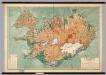
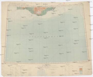
Iceland -- Physical-Political
1 : 500000 Danish General Staff
Charte von Island und den Färöer Inseln
1 : 1400000 Faerské ostrovy Streit, Friedrich Wilhelm