Maps of Germany
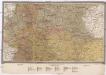
[Politische Karte von Deutschland]
1 : 92500 Německo A. Leykum's [Witwe]
General Carte der gesammten Königlichen Preussischen Länder
1 : 1800000 Mollova mapová sbírka Schleuen, Johann David Schleuen, Johann David
Charte des gegenwärtigen Kriegs in Teutschland ou la Guerre presente
1 : 2800000 Mollova mapová sbírka Friedrich, Jacob Andreas Frédéric, Jacques-André
Charte des gegenwärtigen Kriegs in Teutschland ou la Guerre presente
1 : 2800000 Mollova mapová sbírka Friedrich, Jacob Andreas Frédéric, Jacques-André
Norddeutsche Bundesstaaten
Evropa střední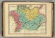
Germania Antiqua. (1826)
1 : 4400000 Tanner, Henry S.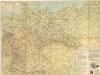
Strassenzustandskarte von Deutschland

Karte des Central-Kriegsschauplatzes in Deutschland
1 : 2000000 Evropa střední Eduard Hölzel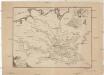
Ideal Postcharte von Boehmen
Evropa střední Berka, Jan Wenzel Schwarz
Ideal Postcharte von Boehmen
Evropa střední Berka, Jan Wenzel Schwarz
Kriminalistiche Karten
Francie Meyer, Joseph Bibliographisches Institut
Verbreitung einiger Krankheiten in Deutschland
Německo Meyer, Joseph Bibliographisches Institut
Regni Borussiae et Electoratus Brandenburgici, Ceterarum que, Quae Fridirici Reg. Bor. sceptro reguntur nec non finitimarum Prov. Delineatio
1 : 2000000 Mollova mapová sbírka Schenk, Pieter Schenk, Peter I
Regni Borussiae et Electoratus Brandeburgici, Ceterarumque Quae Friderici Regis Boruss. sceptro reguntur nec non finitimarum Provinciarum Delineatio
1 : 2000000 Mollova mapová sbírka Halma, François Halma, Franciscus
Germany : International frontiers 1937 : internal boundaries 1944
1 : 1600000 [London] : [War Office]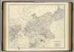
Prussia.
1 : 2032000 Johnston, Alexander Keith, 1804-1871
Mitteleuropa
Evropa střední
Carta Generale di tutta Alemagna, e Paesi circonuicini
Mollova mapová sbírka Gualdo Priorato, Galeazzo
[Poštovní mapa]
Evropa střední Schwarz, Wenzel Koch, Josef Wenzl Schwarz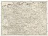
[Poštovní mapa střední Evropy]
Evropa střední Schwarz, Wenzel Koch, Josef Wenzl Schwarz
Post-Karte
Evropa střední Schwarz, Wenzel Koch, Josef Wenzl Schwarz
Říše Česká za Karla IV
Tschechische Republik Polen Böhmen Karl IV.
Preussischer Staat.
1 : 2800000 Flemming, Carl
Germania Ptolemaei
1 : 3600000 Mollova mapová sbírka Weigel, Christoph Weigel, Christoph I.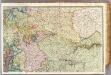
France 2.
1 : 1170000 Brue, Adrien Hubert, 1786-1832; Herisson, Eustache, b. 1759
Norddeutsche Bundesstaaten
Evropa střední
Zur Geschichte des dreissigjährigen Krieges
Evropa střední R. Gaertner
Prussia.
1 : 3200000 Tanner, Henry S.
[Polsko]
Polsko
![[Politische Karte von Deutschland]](https://images-2.georeferencer.com/images/iiif/657233941160/full/,300/0/native.jpg)

