Maps of Hollabrunn

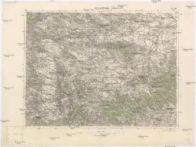
Hollabrunn
1 : 75000 Rakousko Vojenský zeměpisný ústav
III. vojenské mapování 4556
1 : 75000
III. vojenské mapování 4556
1 : 75000
III. vojenské mapování 4556/2
1 : 25000
[Gradkartenblatt]
1 : 25000 Dolní Rakousko (Rakousko) Kartographisches Institut
[Gradkartenblatt]
1 : 25000 Jaroslavice-oblast (Znojmo, Česko)
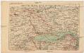
Šengrabenskīj boj 4-go nojabrja 1805 g.
Österreich Hollabrunn Napoleonische Kriege
[Gradkartenblatt]
1 : 25000 Morava (Česko)
III. vojenské mapování 4556/1
1 : 25000
Ober Hallabrunn.
from Spezialkarte der osterreichisch-ungarischen Monarchie.
Localstrecke von Wien K. F. J. B. bis Krems mit Umgebung
Kremže (Rakousko) K. k. Österreichische Staatsbahnen
Unter Mannhartsberg
1 : 640000 Mollova mapová sbírka Insprugger, Sebastianus Voigt, Maria Theresia
Normální mezinárodní letecká mapa.

Das in dem Ertzhertzogtumb Vnter Osterreich
1 : 246000 Dolní Rakousko (Rakousko) Vischer, Georg Matthaeus Hoffmann, Jakob
Generální mapa Protektorátu Čechy a Morava

Generalkarte 1:200 000 zum Kriegsspielplan von Poisdorf
1 : 200000 Poysdorf (Rakousko) K.u.k militär-geographisches Institut
Znaim 132, uit: Special-Karte von Mittel-Europa / nach amtlichen Quellen bearbeitet von W. Liebenow
1 : 300000 titelvariant: W. Liebenow's Mittel-Europa; Annotatie: Titel boven de bladen: W. Liebenow's Mittel-Europa Johannes Wilhelm Liebenow 1822-1897 Frankfurt a. M. : Ludwig Ravenstein
Ob Mannharts Berg
1 : 640000 Mollova mapová sbírka Insprugger, Sebastianus Märtin, Johann Heinrich Voigt, Maria Theresia
Karte der Linie Wien-Znaim der oesterr. Nordwestbahn
1 : 350000 Vídeň-oblast (Rakousko) Lepař, Jan Raffelsperger, Franz artist. Anst. v. L.C. Zamarski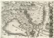
Archiducatus Austriae inferioris Geographica, et Nouiter Emendata Accuratissima Descriptio :
1 : 153333 Mollova mapová sbírka Vischer, Georg Matthaeus Hoffmann, Jakob
Austriacis Legio populis insignia prima Haec Romana dedit: quae Decus vsq; manent Altera Lupoldus dimicatis Virtute parauit Corpore clum, toto Sanguine tinctus erat
1 : 153333 Mollova mapová sbírka Vischer, Georg Matthaeus Hoffmann, Jakob
Brünn
1 : 200000 Brno-oblast (Česko)
Znaim.
from Spezialkarte der osterreichisch-ungarischen Monarchie.
Handkarte des politischen Bezirkes Korneuburg
Umgebungen von Krems

Mistelbach (Nieder-Osterreich).
from Spezialkarte der osterreichisch-ungarischen Monarchie.
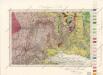
Geognostische Karte der Umgebungen von Krems und von Manhardsberge
1 : 71200 Kremže (Rakousko) Čížek, Johann
[Mapový list]
1 : 25000 Jaroslavice-oblast (Znojmo, Česko) Zeměpisný ústav ministersta vnitra