Maps of Marienberg

Sebastiansberg und Sächs. Annaberg
1 : 75000 Hora Svatého Šebestiána-oblast (Česko) K. u. k. Militärgeographisches Institut
Sebastiansberg und Sächs. Annaberg
1 : 75000 Čechy (Česko) Brunner, J. K. u. k. Militärgeographisches Institut
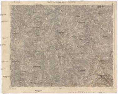
III. vojenské mapování 3750
1 : 75000
Hora Sv. Šebestiána
1 : 75000 Hora Svatého Šebestiána (Česko) Vojenský zeměpisný ústav
Hora Sv. Šebestiána
1 : 75000 Hora Svatého Šebestiána-oblast (Česko) Vojenský zeměpisný ústav
Hora Sv. Šebestiána
1 : 75000 Hora Svatého Šebestiána (Česko) Vojenský zeměpisný ústav
[Kartenblatt]
1 : 25000 Hora Svatého Šebestiána-oblast (Česko) Reichsamt für Landesaufnahme
[Kartenblatt]
1 : 25000 Annaberg-Buchholz (Německo) Reichsamt für Landesaufnahme
III. vojenské mapování 3750/4
1 : 25000
III. vojenské mapování 3750/4
1 : 25000
III. vojenské mapování 3750/4
1 : 25000
III. vojenské mapování 3750/4
1 : 25000
Meßtischblatt 5445 : Sebastiansberg, 1939
1 : 250000 Sebastiansberg. - Aufn. 1914, 1919 u. 1920, hrsg. 1924, bericht. 1936 u. 1938. - 1:25000. - Leipzig, 1939. - 1 Kt.
Meßtischblatt 5445 : Reitzenhain, 1938
1 : 250000 Reitzenhain. - Umdr.-Ausg., aufgen. 1914, 1919 u. 1920, hrsg. 1924, einz. Nachtr. 1932. - 1:25000. - Leipzig, 1938. - 1 Kt.
Meßtischblatt 139 : Annaberg, 1935
1 : 250000 Annaberg. - Umdr.-Ausg., aufgen. 1914, 1919 u. 1920, hrsg. 1924, bericht. 1932. - 1:25000. - Leipzig, 1935. - 1 Kt.
Meßtischblatt 5345 : Zöblitz, 1937
1 : 250000 Zöblitz. - Umdr.-Ausg., aufgen. 1914/20, hrsg. 1926, einz. Nachtr. 1934. - 1:25000. - Leipzig, 1937. - 1 Kt.
Meßtischblatt 128 : Marienberg, 1934
1 : 250000 Marienberg. - Umdr.-Ausg., aufgen. 1914, 1919 u. 1920, hrsg. 1924, einz. Nachtr. 1934. - 1:25000. - Leipzig, 1934. - 1 Kt.
Meßtischblatt 5443 : Buchholz, 1944
1 : 250000 Buchholz. - Aufn. 1914, 1919 u. 1920, hrsg. 1924, bericht. 1936, Ausg. 1943. - 1:25000. - Leipzig, 1944. - 1 Kt.
Meßtischblatt 5443 : Buchholz, 1942
1 : 250000 Buchholz. - Aufn. 1914, 1919 u. 1920, hrsg. 1924, bericht. 1936. - 1:25000. - Leipzig, 1942. - 1 Kt.
Meßtischblatt 5343 : Geyer, 1939
1 : 250000 Geyer. - Umdr.-Ausg., aufgen. 1914, 1919 u. 1920, einz. Nachtr. 1935. - 1:25000. - Leipzig, 1939. - 1 Kt.


Karte des Bezirkes Sebastiansberg
1 : 37000 Hora Svatého Šebestiána-oblast (Česko) Hollmann, Vict. Jos. Mécsery de Tsóor, Karl Johann Freiherr von Friedrich Selner
Natschung - c4936-1-002 - Kaiserpflichtexemplar der Landkarten des stabilen Katasters
1 : 2880
Natschung - c4936-1-001 - Kaiserpflichtexemplar der Landkarten des stabilen Katasters
1 : 2880
Natschung - c4936-1-007 - Kaiserpflichtexemplar der Landkarten des stabilen Katasters
1 : 2880
Natschung - c4936-1-006 - Kaiserpflichtexemplar der Landkarten des stabilen Katasters
1 : 2880
Natschung - c4936-1-004 - Kaiserpflichtexemplar der Landkarten des stabilen Katasters
1 : 2880
Natschung - c4936-1-003 - Kaiserpflichtexemplar der Landkarten des stabilen Katasters
1 : 2880