Maps of okres Liberec

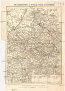
Umgebungskarte zu Woerl's Führer
1 : 220000 Liberec-oblast (Česko) Woerl's Reisebücherverlag
Generální mapa okresních hejtmanství

Generální mapa okresních hejtmanství

Generalkarte der Bezirkshauptmannschaft Reichenberg
1 : 220000 Liberec-oblast (Česko) Wagner, Jan Eduard F. Kytka
Generalkarte der Bezirkshauptmannschaft Reichenberg
1 : 220000 Liberec-oblast (Česko) Wagner, Jan Eduard F. Kytka
Regni Bohemiae Circulus Boleslaviensis
1 : 210000 Boleslav-oblast (Černousy, Česko) Müller, Johann Christoph ab Homannianis Heredibus
Regni Bohemiae Circulus Boleslaviensis
1 : 210000 Boleslav-oblast (Černousy, Česko) Müller, Johann Christoph in lucem editus ab Homannianis Heredibus
Regni Bohemiae circulus Boleslaviensis
1 : 210000 Boleslav-oblast (Černousy, Česko) Müller, Johann Christoph in lucem editus ab Homannianis Heredibus
Jizerské hory

Die Umgegend von Reichenberg
1 : 115200 Liberec-oblast (Česko) Hickmann, Anton L. Verbeek
Touristen-Karte vom Jeschken- u. Isergebirge
1 : 80000 Ještědský hřbet (Česko) Straube, Julius Matouschek, Josef Paul Sollors Nachf.
Reichenberg u. Friedland.
from Spezialkarte der osterreichisch-ungarischen Monarchie.
Bez titulu: Okolí Liberce a Turnova

Mapa okresních hejtmanství Libereckého a Jabloneckého

Generální mapa okresních hejtmanství

II. vojenské mapování 3
1 : 144000
II. vojenské mapování 3
1 : 144000
Special - Karte des Koenigreiches Boehmen

Generální mapa okresního hejtmanství Turnovského
1 : 220000 Turnov-oblast (Česko) Wagner, Jan Eduard F. Kytka
Karte des Bezirkes Reichenberg
Mapy plánování ČSR

Reichenberg u. Friedland
1 : 75000 Frýdlant (Česko : oblast) Reichenauer K. u. k. Militärgeographisches Institut
Reichenberg u. Friedland
1 : 75000 Frýdlant (Česko : oblast) Reichenauer K. u. k. Militärgeographisches Institut
Reichenberg u[nd] Friedland
1 : 75000 Frýdlant (Česko : oblast) K. u. k. Militärgeographisches Institut
Podrobná mapa Království českého, Markrabství moravského a Vévodství slezského
1 : 100000 Jablonec nad Nisou (Česko : oblast) Srp, Jan Jos. R. Vilímek
Liberec a okolí
1 : 75000 Liberec (Česko : oblast) Vojenský zeměpisný ústav
Karte der Bezirkshauptmannschaften Reichenberg und Gablonz
1 : 100000 Jablonec nad Nisou-oblast (Česko) Erben, Josef Karl Janský
III. vojenské mapování 3654
1 : 75000
Liberec
1 : 75000 Liberec-oblast (Česko) Vojenský zeměpisný ústav
Liberec
1 : 75000 Liberec (Česko : oblast) Vojenský zeměpisný ústav