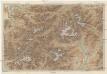
Maps of Gschnitz

Habicht
1 : 50000 Stubaiské Alpy (Itálie a Rakousko : pohoří) Deutscher und Oesterreichischer Alpenverein
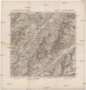
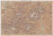
Otzthal.
from Spezialkarte der osterreichisch-ungarischen Monarchie.
Matrei.
from Spezialkarte der osterreichisch-ungarischen Monarchie.
Oetzthal & Stubai
1 : 50000 Nordost-Blatt Simon, Simon Deutscher u. Oesterreichischer Alpen-Verein
Schrankogel
1 : 50000 Stubaiské Alpy (Itálie a Rakousko : pohoří) Deutscher und Oesterreichischer Alpenverein
Brenner-Bahn
1 : 96000 Bolzano (Itálie) Fr. Unterberger's Kunsthandlung
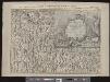
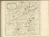
Per Inclyti Circuli Suevici Supremorum Ordinum
1 : 160000 Mollova mapová sbírka Pfeffel, Johann Andreas Homann, Johann Baptista - dědici
Per Inclyti Circuli Suevici Supremorum Ordinum :
1 : 160000 Mollova mapová sbírka Pfeffel, Johann Andreas Pfeffel, Johann Andreas I.
[Stubaier Alpen]
1 : 100000 Stubaiské Alpy (Itálie a Rakousko : pohoří) Freytag & Berndt
Innsbruck 157, uit: Special-Karte von Mittel-Europa / nach amtlichen Quellen bearbeitet von W. Liebenow
1 : 300000 titelvariant: W. Liebenow's Mittel-Europa; Annotatie: Titel boven de bladen: W. Liebenow's Mittel-Europa Johannes Wilhelm Liebenow 1822-1897 Frankfurt a. M. : Ludwig Ravenstein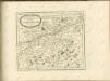
B.Z. - Karte von Oesterreich

Tyrolis sub Felici Regimine Mariae Theresiae Rom. Imper. Avg. Chorographice Delineata ...
1 : 104000 Mollova mapová sbírka Mansfeld, Johann Ernst Mansfeld, Johann Ernest
Tyrolis sub Felici Regimine Mariae Theresiae Rom. Imper. Avg. Chorographice Delineata ...
1 : 104000 Mollova mapová sbírka Mansfeld, Johann Ernst Mansfeld, Johann Ernest
Tyrolis sub Felici Regimine Mariae Theresiae Rom. Imper. Avg. Chorographice Delineata ...
1 : 104000 Mollova mapová sbírka Mansfeld, Johann Ernst Mansfeld, Johann Ernest
Tyrolis sub Felici Regimine Mariae Theresiae Rom. Imper. Avg. Chorographice Delineata ...
1 : 104000 Mollova mapová sbírka Mansfeld, Johann Ernst Mansfeld, Johann Ernest
Füssen
1 : 200000 1 Karte entworfen und bearbeitet von Woerl ; in Stein gestochen unter seiner Leitung 1835 Herder, Freiburg im Breisgau
Meran
1 : 200000 1 Karte entworfen und bearbeitet von Woerl ; in Stein gestochen unter seiner Leitung ; Lithographie von B. Herder Herder, Freiburg im Breisgau
Strecke
Bludenz (Rakousko) K. k. Österreichische Staatsbahnen
Engadin-Orientbahn
1 : 250000 1:250 000 Schweiz Eidgenössisches Topographisches Bureau Eidg. Topographisches Bureau
Karte der West - Tiroler und Engadiner – Alpen
Karte der West-Tiroler und Engadiner Alpen
1 : 250000 Engadin (Švýcarsko) Ravenstein, Ludwig L. Ravenstein
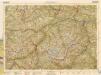
Vorarlberg - Oetzthaler Alpen - Brenner
1 : 850000 Bibliographisches Institut
Generalkarte von Zentraleuropa
Karte der West-Tiroler und Engadiner Alpen
1 : 250000 Engadin (Švýcarsko) Ravenstein, Ludwig Geographische Anstalt von L. Ravenstein
Carte topographique d'Allemagne contenant une partie de Bavére, de Suabe, du comté de Tirol et de l'évêché d'Augspourg, l'Algow, les quatre seigneuries autrichienne devant la montagne d'Arlenberg
1 Karte fait par I. W. Iaeger chez l'auteur, Francfort sur le Mein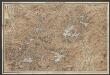
Karte der West-Tiroler und Engadiner Alpen
1 : 250000 Ravenstein, Ludwig Geographische Anstalt von L. Ravenstein
Tirolis
Mollova mapová sbírka Hoffmann, Johannes Hoffmann, Johann