Maps of Bohinj

Julische Alpen
1 : 50000 Julské Alpy (Itálie a Slovinsko : pohoří) K. u. k. Militärgeographisches Institut
Julijske Alpe
1 : 75000 Julské Alpy (Itálie a Slovinsko) Knafelc, Alojz Slov. Plan. društvo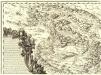
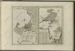
Ducatus Carnioliae Tabula Chorographica Iusu Sumptuque inclytorum Provinciae Statuum.
1 : 100000 Mollova mapová sbírka Florjančič de Grienfeld, Janez Dizma
Radmannsdorf.
from Spezialkarte der osterreichisch-ungarischen Monarchie.
Radmannsdorf
1 : 75000 Radovljica, Radovljica (Region)
Yugoslavia 1:100,000, Bled
Yugoslavia 1:100,000 , Series GSGS 4396. Great Britain. War Office. [London] : War Office
St. Jakob
1 : 25000 Kartographisches Institut
Comitatus Goritiae et Gradiscae
1 : 216000 Mollova mapová sbírka Coronini, Rudolf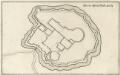
Gründt Riß der Statt Görtz
Mollova mapová sbírka Merian, Matthaeus Merian, Caspar
Comitatus Goritiae et Gradiscae cum limitibus Venetis et vicinia
1 : 220000 Benátky (Itálie) Coronini, Rudolf Quischae, D.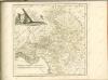

Unterkaernten oder der Klagenfurter Kreis
1 : 250000 Klagenfurt-oblast (Rakousko) Kindermann, Joseph Karl Junker, Christoph Franz Xaver Miller
Dioecesan-Carte von Laibach
1 : 260000 Lublaň-oblast (Slovinsko) Mascon, Johann Wolf, Anton Alojzij Johann Mascon
Der Goerzer Kreis und der Triester Kreis
1 : 260000 Gorizia (Itálie) Kindermann, Joseph Karl Junker, Christoph Franz Xaver Miller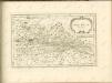

Comitatus Goritiae Et Finitima
1 : 115000 Mollova mapová sbírka Coronini, Rudolf Winkler, Johann Christoph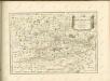

Flitsch.
from Spezialkarte der osterreichisch-ungarischen Monarchie.
Ljubljana
1 : 200000 Lublaň (Slovinsko : oblast) Kartografska radionica
Klagenfurt und Villach.
from Spezialkarte der osterreichisch-ungarischen Monarchie.
Bischoflack und Idria.
from Spezialkarte der osterreichisch-ungarischen Monarchie.
Nördliches Isonzogebiet
Isonzo-Gebiet Isonzoschlachten
Italy 1:100,000 / Sardinia 1:100,000, Tolmino
Italy 1:100,000 / Sardinia 1:100,000 , Series GSGS 4164. Great Britain. War Office. General Staff. Geographical Section. [London] : War Office
Italy 1:100,000 / Sardinia 1:100,000, Idria
Italy 1:100,000 / Sardinia 1:100,000 , Series GSGS 4164. Great Britain. War Office. General Staff. Geographical Section. [London] : War Office
Bleiberg und Tarvis.
from Spezialkarte der osterreichisch-ungarischen Monarchie.
Tolmein.
from Spezialkarte der osterreichisch-ungarischen Monarchie.
Zone 21, Kol. X, Bischoflack und Idria, uit: Geologische Karte der im Reichsrathe vertretenen Königreiche und Länder der Österreich-Ungarischen Monarchie : auf Grundlage der Specialkarte i.M. 1:75.000 des k.u.k. Militär-geographischen Institutes / neu bearb. und als Kartenwerk von 341 Blattnummern in zwanglosen Lfg. hrsg. durch die k.k. Geologische Reichsanstalt in Wien
1 : 75000 titelvariant: Geologische Spezialkarte der im Reichsrate vertretenen Königreiche und Länder der Österreichisch-Ungarischen Monarchie; Geologische Specialkarte der im Reichsrathe vertretenen Königreiche und Länder der Österreichisch-Ungarischen Monarchie; Annotatie: Titel bovenaan kaartblad: Geologische Spezialkarte der im Reichsrate vertretenen Königreiche und Länder der Österreichisch-Ungarischen Monarchie en Geologische Specialkarte der im Reichsrathe vertretenen Königreiche und Länder der Österreichisch-Ungarischen Monarchie; Annotatie geografische gegevens: Coördinaten gebaseerd op nulmeridiaan van Ferro (Hierro) Kaiserlich-Königliche Geologische Reichsanstalt, Wenen Wien : K.K. Geologische Reichsanstalt
Aus der Übersichtskarte von Mittel-Europa 1:750 000
1 : 750000 Evropa střední K. k. Österreichische Staatsbahnen
Carta delle contee di Gorizia, di Gradisca, distetto di Trieste, e del Friuli Veneto
1 : 208000 Burgenland (Rakousko) Capellaris, Giann Antonio Tommasini