Maps of Provodov-Šonov
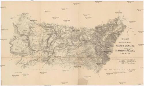
Plan des Gefechtsfeldes von Nachod, Skalitz und Schweinschaedel am 27, 28 u. 29 Juni 1866
1 : 25000 Náchod-oblast (Česko) Baumann Karten-debit königl. preussische Landesaufnahme
Plan des Gefechtsfeldes von Nachod, Skalitz und Schweinschaedel am 27, 28 u. 29. Juni 1866
1 : 25000 Náchod-oblast (Česko) Baumann
[Wenzelsberg und Umgebung]
1 : 25000 Václavice (Provodov-Šonov, Česko)
Kleny - c3153-1-003 - Kaiserpflichtexemplar der Landkarten des stabilen Katasters
1 : 2880
Kleny - c3153-1-002 - Kaiserpflichtexemplar der Landkarten des stabilen Katasters
1 : 2880
Kleny - c3153-1-004 - Kaiserpflichtexemplar der Landkarten des stabilen Katasters
1 : 2880
Kleny - c3153-1-005 - Kaiserpflichtexemplar der Landkarten des stabilen Katasters
1 : 2880
Kleny - c3153-1-001 - Kaiserpflichtexemplar der Landkarten des stabilen Katasters
1 : 2880
Skalitz (Skalice) - c0960-1-004 - Kaiserpflichtexemplar der Landkarten des stabilen Katasters
1 : 2880
Skalitz (Skalice) - c0960-1-002 - Kaiserpflichtexemplar der Landkarten des stabilen Katasters
1 : 2880
Skalitz (Skalice) - c0960-1-003 - Kaiserpflichtexemplar der Landkarten des stabilen Katasters
1 : 2880
Skalitz (Skalice) - c0960-1-001 - Kaiserpflichtexemplar der Landkarten des stabilen Katasters
1 : 2880
Schonow - c7755-1-001 - Kaiserpflichtexemplar der Landkarten des stabilen Katasters
1 : 2880
Schonow - c7755-1-004 - Kaiserpflichtexemplar der Landkarten des stabilen Katasters
1 : 2880
Schonow - c7755-1-002 - Kaiserpflichtexemplar der Landkarten des stabilen Katasters
1 : 2880
Schonow - c7755-1-003 - Kaiserpflichtexemplar der Landkarten des stabilen Katasters
1 : 2880
Zernow - c9412-1-001 - Kaiserpflichtexemplar der Landkarten des stabilen Katasters
1 : 2880
Zernow - c9412-1-003 - Kaiserpflichtexemplar der Landkarten des stabilen Katasters
1 : 2880
Zernow - c9412-1-004 - Kaiserpflichtexemplar der Landkarten des stabilen Katasters
1 : 2880
Zernow - c9412-1-002 - Kaiserpflichtexemplar der Landkarten des stabilen Katasters
1 : 2880
Nachod - c4950-1-002 - Kaiserpflichtexemplar der Landkarten des stabilen Katasters
1 : 2880
Nachod - c4950-1-004 - Kaiserpflichtexemplar der Landkarten des stabilen Katasters
1 : 2880
Nachod - c4950-1-001 - Kaiserpflichtexemplar der Landkarten des stabilen Katasters
1 : 2880
Nachod - c4950-1-003 - Kaiserpflichtexemplar der Landkarten des stabilen Katasters
1 : 2880
Nachod - c4950-1-005 - Kaiserpflichtexemplar der Landkarten des stabilen Katasters
1 : 2880
Wisokow - c8964-1-003 - Kaiserpflichtexemplar der Landkarten des stabilen Katasters
1 : 2880
Wisokow - c8964-1-002 - Kaiserpflichtexemplar der Landkarten des stabilen Katasters
1 : 2880
Wisokow - c8964-1-001 - Kaiserpflichtexemplar der Landkarten des stabilen Katasters
1 : 2880
Wisokow - c8964-1-004 - Kaiserpflichtexemplar der Landkarten des stabilen Katasters
1 : 2880