Maps of Moldova

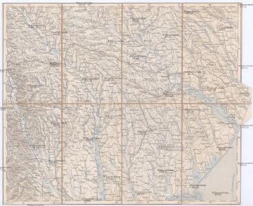
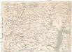
Bielcy, Kisziniew, Jassi
1 : 750000 Jasy (Rumunsko) Czerny, Eduard K. u. k. Militärgeographisches Institut
Bielcy, Kisziniew, Jassi
1 : 750000 Jasy (Rumunsko) K. k. militär-geographisches Institut
Übersichtskarte von Mittel - Europa
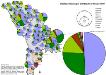
Stadtbevölkerung in der Republik Moldau 1989
Moldawien Stadtbevölkerung Hofinger, Veronika
Carte de la Roumanie et pays limitrophes. Odessa
1 : 500000 France. Service géographique de l'armée [Paris] : Service géographique de l'armée
Republik Moldau 1989. Ethnische Zusammensetzung der Bevölkerung - Moldauer (Rumänen)
Moldawien ethnische Gruppe, Moldauer Hofinger, Veronika
Republik Moldau 1989. Ethnische Zusammensetzung der Bevölkerung - Ukrainer
Moldawien ethnische Gruppe, Ukrainer Hofinger, Veronika
Rumänisch-russische Grenze
1 : 1500000 Bessarabien Grenze
Rumänisch-russische Grenze (Bessarabien)
1 : 1500000 Bessarabien Grenze
Bez titulu: Šest listů speciálních map Ukrajiny

Kʺ pochodu 1711 goda.
Moldawien Nordischer Krieg <1700-1721>
Die Moldau
1 : 1000000 Moldavsko Kiepert, Heinrich Luther, Theodor Geographisches Institut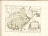
Grande Valacchia e Moldavia
Moldova (Rumunsko)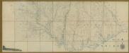
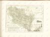
Carte de la Moldavie
1 : 330000 Moldawien, Bessarabien
Republik Moldau 1989. Ethnische Zusammensetzung der Bevölkerung - Bulgaren
Moldawien ethnische Gruppe, Bulgaren Hofinger, Veronika
Republik Moldau 1989. Ethnische Zusammensetzung der Bevölkerung - Gagausen
Moldawien ethnische Gruppe, Gagausen Hofinger, Veronika
Plan des tapfern Angriffs und vollkommenen Sieges der russisch-kayserlichen Waffen über die Turkische und Tatarische Arméé an der Large in der Moldau den 7. Iuly 1770
1 : 40000 Moldavsko
Trigonometrisk grunnlag, vedlegg 65, 2-5: Grunnlagspunkter for Struves meridianbue fra Bessarabia og Volhynia
1 : 200000 de Tenner
Bocche del Danubio
1 : 483000 Dunaj (Rumunsko a Ukrajina : řeka : delta)
Harta Cailor de Comunicatie din Judetul Tecuci
Rumänien Tecuci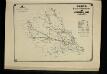
Harta Cailor de Comunicatie din Judetul Iasi
Rumänien Jassy
Harta Cailor de Comunicatie din Judetul Tutova
Rumänien Kreis Tutova Verkehrsweg
Transnistrien 1989. Ethnische Zusammensetzung der Bevölkerung - Moldauer (Rumänen)
Transnistrien ethnische Gruppe, Moldauer Hofinger, Veronika
Harta Cailor de Comunicatie din Jud. Covurluiu
Rumänien Judeţul Covurlui Verkehrsweg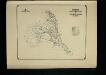
Harta Cailor de Comunicatie din Judetul Putna
Rumänien Putna Verkehrsweg
Harta Cailor de Comunicatie din Judetul Vaslui
Rumänien Judeit Vaslui Verkehrsweg
Harta Cailor de Comunicatie din Judetul Falciu
Rumänien Kreis Fălciu Verkehrsweg