Maps of Greece
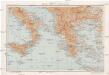
Řecko, Albanie a jižní Italie [sic]
1 : 2500000 Albánie V. Neubert a synové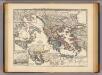
Graecia, Macedonia, Thracia etc. inde a belli Peloponnesiaci tempore.
1 : 3900000 Menke, Th.
Südosteuropäische Halbinsel
1 : 4500000 Balkanhalbinsel

Balkan Halbinsel.Stumme Physikalische Schul-Wandkarten der Länder Europas
mapa VKOL Kiepert, Richard Verlag von Dietrich Reimer
Balkan-Halbinsel.Politische Schul-Wandkarten der Länder Europa's
mapa VKOL Kiepert, Richard Verlag von Dietrich Reimer
Verkehrspolitische Karte der Balkanstaaten
1 : 2500000 balkánské země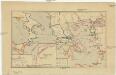
Řecko a jeho kolonie r. 500 př. Kr
Řecko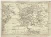
Das alte Griechenland mit dessen vmliegenden Insvlen
Řecko
Grece et ses Colonies.
Andriveau-Goujon, J.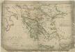
Atlas orbis antiqui totius secundum optimos scriptores ...

H. Kiepert's Generalkarte der südost-europäischen Halbinsel
1 : 1500000 Balkánský poloostrov Bischoff, C. Kiepert, Heinrich Dietrich Reimer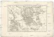
Graecia vetus
1 : 7900000 Řecko Bonne, Rigobert André
Decima Et Ultima Tabula Europae [Karte], in: Claudii Ptolemei viri Alexandrini mathematice discipline philosophi doctissimi geographie opus [...], S. 178.
1 Karte aus Atlas Waldseemüller, Martin [und Ptolemaeus, Claudius] Übelin, Georg
Tabula Europae X. [Karte], in: Claud. Ptolemaeus. Geographia lat. cum mappis [...], S. 281.
1 Karte aus Atlas Münster, Sebastian [und Ptolemaeus, Claudius]
Feuille 39 (D VI), uit: Carte géologique internationale de l'Europe : la carte, votée au congrès géologique international de Bologne en 1881, est exécutée conformément aux décisions d'une commission internationale, avec le concours des gouvernements, sous le dir. de M.M. Beyrich et Hauchecorne
Annotatie: Blad 48 gamme des couleurs; blad 49: bladwijzer en titelblad Heinrich Ernst Beyrich 1815-1896; Wi. Hauchecorne Berlin : Reimer / (Berlin: Institut lithographique)
Tabula Europae X. [Karte], in: Geographia universalis vetus et nova complectens Claudii Ptolemaei Alexandrini enarrationis libros VIII, S. 251.
1 Karte aus Atlas Münster, Sebastian [und Ptolemaeus, Claudius]
Bodenschätze und Industrie
Balkanhalbinsel Wirtschaft, Mineralischer Rohstoff
99-100. Balkan Peninsula, Aegean Sea. The World Atlas.
1 : 2500000 USSR (Union of Soviet Socialist Republics).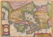
[Hellás], Graecia Sophiani. [Karte], in: Theatrum orbis terrarum, S. 404.
1 Karte aus Atlas Ortelius, Abraham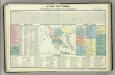
Tableau historique de la Grece.
1 : 5500000 Duval, Henri
Letecká navigační mapa

Übersichtskarte von Griechenland
Originaltitel: Carte Griechenlands nach den neuesten und besten Quellen bearbeitet. Mit Erklärung der Zeichen sowie einer Nebenkarte. Fischer, J., Lithograf

Carte de la Turque d'Europe et de la Grece.
1 : 3450000 Vivien de St Martin, L.
Turecká říše w Ewropé, Řecko, Jonické ostrowy
1 : 6500000 Jónské ostrovy (Řecko) Merklas, Václav
Anbau und Juli-Isothermen
Balkanhalbinsel Pflanzenbau, Klima
Decima Europe Tabula [Karte], in: [Clavdii Ptholomei Cosmographi ...], S. 284.
1 Karte aus Atlas Nicolaus Germanus [und Ptolemaeus, Claudius]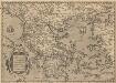
Graeciae Universae Secundum Hodiernum Situm Neoterica Descriptio. [Karte], in: Theatrum orbis terrarum, S. 347.
1 Karte aus Atlas Ortelius, Abraham Vrients, Jan Baptista
![Řecko, Albanie a jižní Italie [sic]](https://images-2.georeferencer.com/images/iiif/344178611570/full/,300/0/native.jpg)

