Maps of Germany

[Západní Evropa]
1 : 1600000 Evropa západní Fastrův mapový atelier
G. Freytags Übersichtskarte des deutsch-französischen Kriegsschauplatzes
1 : 2000000 Evropa západní Kartogr. Anstalt G. Freytag & Berndt
[Kaart], uit: G. Freytags Übersichtskarte des Deutsch-Französischen Kriegsschauplatzes
1 : 2000000 titelvariant: Übersichtskarte des Deutsch-Französischen Kriegsschauplatzes; Annotatie: Omslagtitel: Übersichtskarte des Deutsch-Französischen Kriegsschauplatzes Freytag, G. Wien : Freytag & Berndt
Germany.
from A new systeme of the mathematicks: containing I. Arithmetick, as well natural and decimal, as in species, or the principles of algebra. II. Practical geometry, together with the first six books of Euclid's Elements, as also the eleventh and twelfth, symbo
Germany.
from Carey's general atlas, improved and enlarged : being a collection of maps of the world and quarters, their principal empires, kingdoms, &c.
Nouvelle carte de poste de tout l'empire Français, de l'Angleterre, de l'Italie, d'une partie de l'Espagne et de l'Allemagne, etc. = Neueste Post Karte vom ganzen Französischen Reiche, England, Italien, und einem Theile von Spanien und Deutschland uzw. / hrsg. und verlegt von J.C. Hinrichs
1 : 2800000 Hinrichs, J. C. Leipzig : Hinrichs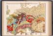
Mitteleuropa, Geologische Übersicht
1 : 3500000 Scobel, Albert
Outline Europe.
1 : 4600000 Wauthier, J. M.
Europe.
1 : 4600000 Wauthier, J. M.
Karte der Eisenbahnen Mittel - Europa ́s ...
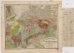
Geologische Karte von Central Europa
1 : 2640000 Evropa střední Bach, Heinrich E. Schweizerbart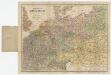
[Kaart], uit: Reise-Karte von Mittel-Europa : mit Angabe der Bahnstationen und Postverbindungen / entworfen und gezeichnet von M. Hermann
1 : 2800000 titelvariant: Reisekarte von Mittel-Europa; Annotatie: Omslagtitel: Reisekarte von Mittel-Europa Hermann, M. Glogau : Carl Flemming
Nouvelle carte de poste de tout l'empire Français, de l'Anglettere, de l'Italie, d'une partie de l'Espagne et de l'Allemagne etc
Anglie Hinrichs, Johann Conrad J.C. Hinrichs
Allemagne occidentale.
1 : 2000000 Andriveau-Goujon, J.
Special-Karte der Eisenbahn- Post- u[nd] Dampfschiff-Verbindungen Mittel-Europa's
1 : 1240000 Evropa střední Raab, Christian Johann Carl Koch, A. C. Flemming
Special-Karte der Eisenbahn- Post- u[nd] Dampfschiff-Verbindungen Mittel-Europa's
1 : 84000 Evropa střední Raab, Christian Johann Carl Müller, H. C. Flemming
Deutschland
Allgemeiner Atlas [Walch, Johannes] im Verlag bei Johannes Walch
Germania, V. Nova Tabula. [Karte], in: Claud. Ptolemaeus. Geographia lat. cum mappis [...], S. 347.
1 Karte aus Atlas Münster, Sebastian [und Ptolemaeus, Claudius]
Reise-Karte von Mittel-Europa : mit Angabe der Bahnstationen und Postverbindungen / nach den neuesten Quellen entw. u. gezeichnet. von M. Hermann
1 : 2800000 Annotatie: Bijlage bij: J.C. König und Erhardt's Tages-Notizbuch Hermann, M. [S.l. : s.n.] / (Glogau : Flemming)
Neueste Eisenbahn-Karte von Central-Europa
Evropa střední Hendschel, U. Carl Jügel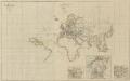
VIII. Charte für die allgemeine Geschichte von Rudolph von Habsburg bis auf Carl V : d.i. von 1273-1519 nach Christus
Entworfen von F.W. Benicken gez. von C.F. Weiland ; in Stein gravirt v. Ant. Falger Weimar : im Verlage des L. Industrie-Comptoirs
Special-Karte der Eisenbahnen Deutschlands und der angrenzenden Länder
1 : 2000000 Haeberlin, R. Ramdohr
Special-karte von Deutschland: nebst einem Theile der angrenzenden Länder mit Gesonderer Berücksichtigung der Gebirge und Gewässer
Fried, Franz
Eisenbahn-Karte von Mittel-Europa
1 : 8200000 Evropa střední
Die Verbreitung des Kropfes in Mittel-Europa
1 : 8000000 Bircher, Heinrich Benno Schwabe, Schweighauserische Verlagsbuchhandlung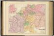
Central Europe with the Railways.
1 : 3168000 Fullarton, A. & Co.
Politisch-statistische Charte von Deutschland nebst dem grössten Theile von Pohlen, einem grossen Theile von Frankreich und Nord-Italien
1 : 2900000 Evropa střední Champion, J. N. Baumann, J. Mitzky & Comp.
Post - und Eisenbahn – Reisekarte Deutschland

Post und Eisenbahn - Reisekarte Deutschland, Holland, Belgien...

![[Západní Evropa]](https://images-2.georeferencer.com/images/iiif/841825077216/full/,300/0/native.jpg)

