Maps of okres Litoměřice
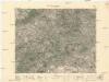
Generalkarte der Bezirkshauptmannschaft Leitmeritz
1 : 220000 Litoměřice-oblast (Česko) Wagner, Jan Eduard F. Kytka
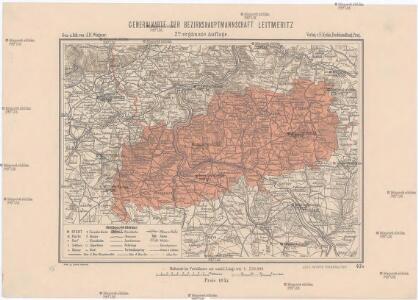
Generalkarte der Bezirkshauptmannschaft Leitmeritz
1 : 220000 Litoměřice-oblast (Česko) Wagner, Jan Eduard F. Kytka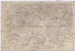
Umgebungen von Leitmeritz und Theresienstadt
1 : 750000 Litoměřice (Česko : oblast) K. k. militär-geographisches Institut
České středohoří

II. vojenské mapování 7
1 : 144000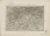
II. vojenské mapování 7
1 : 144000
Aussig und Leitmeritz.
from Spezialkarte der osterreichisch-ungarischen Monarchie.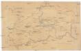
Župa litomeřická [sic] v VIII.-IX. století
Litoměřice-oblast (Česko) Hraše, Jan Karel
Wanderkarte fürs Elbetal und des angrenzenden Gebietes vom Mittel- und Erzgebirge
1 : 75000 Pirna (Německo) Kroitzsch, Carl vom Aussiger Gebirgsverein
Bez titulu: Středohoří
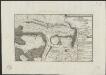
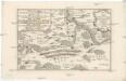
Plan de la battaille de Lobeschüz entre l'Armée Autrichienne et Prussienne sous les ordres de S. M. le Roi de Prusse et le Comte de Broune arrivée le 1. Octob. 1756
desin. par un volontair = entworfen in d. Armee v. einem Volontair [Leipzig] : [s.n.]
Soubor přehledných map pro plánování a statistiku: 3752 – Litoměřice
Lager der kayserl. könig. ungarischen Armée bey Budin in Böhmen von der Schlacht bey Lowositz Anno 1756
Budyně nad Ohří-oblast (Česko)
Ústí n. L. a Litoměřice
1 : 75000 Benešov nad Ploučnicí (Česko : oblast) Vojenský zeměpisný ústav
Aussig und Leitmeritz
1 : 75000 Litoměřice (Česko : oblast) Acham, Stefan K. u. k. militär-geographisches Institut
Aussig und Leitmeritz
1 : 75000 Litoměřice (Česko : oblast) Acham, Stefan K. u. k. Militärgeographisches Institut
Aussig und Leitmeritz
1 : 75000 Litoměřice (Česko : oblast) K. u. k. Militärgeographisches Institut
Litoměřice a okolí
1 : 75000 Litoměřice (Česko : oblast) Vojenský zeměpisný ústav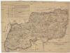
Karte der Bezirkshauptmannschaft zugleich Strafgerichtsbezirk Leitmeritz
1 : 222500 Litoměřice-oblast (Česko) von dem Lehrpersonale der Leitmeritzer k.k. Hauptschule
Soubor přehledných map pro plánování a statistiku: 3752 – Litoměřice

III. vojenské mapování 3752
1 : 75000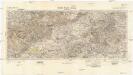
Sayda-Teplitz-Aussig
1 : 100000 Teplice (Česko : oblast) Reichsamt für Landesaufnahme-Reichskartenstelle
Touristen-Karte des Aussiger Mittel- und Erzgebirgs-Vereines
1 : 75000 Krušné hory (Česko a Německo) Kroitzsch, Carl Mittel- und Erzgebirgesverein
Panorama vom Donnersberge (Milleschauer) bei Teplitz
Milešovka (Česko : rozhledna) Medau, Karel Vilém C.W. Medau
Panorama vom Donnersberge (Milleschauer) bei Teplitz
Milešovka (Česko : rozhledna) Medau, Karel Vilém C.W. Medau
Panorama vom Donnersberge (Milleschauer) bei Teplitz
Milešovka (Česko : rozhledna) Medau, Karel Vilém C.W. Medau
Mapa politického a školního okresu Roudnického
1 : 100000 Roudnice nad Labem-oblast (Česko) Okresní výbor školní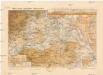
Mapa okres. hejtmanství Roudnického
1 : 100000 Budyně nad Ohří-oblast (Česko) R. Kaška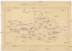
Okresní hejtmanství Roudnické
Roudnice nad Labem-oblast (Česko)
Litoměřice
1 : 75000 Litoměřice-oblast (Česko) Vojenský zeměpisný ústav