Maps of Turkivskyi District

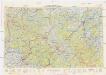
[Gradkartenblatt]
1 : 25000 Ukrajina Vojenský zeměpisný ústav
Smorze und Alsó-Verecke
1 : 75000 Transkarpatien Geripp: Assist. Pflügl. Terrain: Oberlt. Hettwer
III. vojenské mapování 4470
1 : 75000
Verecki a Smorze
1 : 75000 Ukrajina Vojenský zeměpisný ústav
Smorze und Also-Verecke.
from Spezialkarte der osterreichisch-ungarischen Monarchie.
Neubertova generální automapa Republiky československé
1 : 200000 Soukup, Jan V. Neubert a synové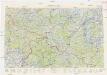
Neubertova generální automapa Republiky československé
1 : 200000 Soukup, Jan V. Neubert a synové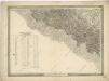
General-Karte des Königreiches Galizien und des Herzogthumes Bukovina

Generalkarte von Zentraleuropa
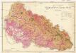
Podkarpatská Rus
1 : 225000 Podkarpatská Rus (Ukrajina) Gregor, František Novotný a Bartošek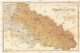
Podkarpatská Rus
1 : 225000 Podkarpatská Rus (Ukrajina) Gregor, František Novotný a Bartošek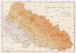
Podkarpatská Rus
1 : 225000 Podkarpatská Rus (Ukrajina) Gregor, František Novotný a Bartošek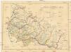
Podkarpatská Rus
1 : 300000 Podkarpatská Rus (Ukrajina) Referát min. veř. prací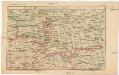
Strecke
Ivano-Frankivsk (Ukrajina) K. k. Österreichische Staatsbahnen
Podkarpatská Rus
1 : 500000 Berehove (Ukrajina) Fastr Eduard
Slovensko

Podkarpatská Rus
1 : 300000 Berehove (Ukrajina) Fastr Eduard
Ost Galizien
Halič (Polsko a Ukrajina) Liesganig, Joseph m Verlage des Kunst- und Industrie- Comptoirs
Vermehrte und Verbesserte Landkarten des Königreichs Ungarn :
1 : 500000 Mollova mapová sbírka Stier, Martin Böner, Johann-Alexander Endter, Martin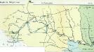
Nr. 6b. Kämpfe in Ostgalizien. Im Dnjestrgebiet
Galizien Weltkrieg <1914-1918>, Ostfront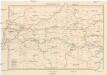
Galizien, Westlicher Theil
1 : 700000 Halič (Polsko a Ukrajina) Karl Fr. Pfau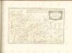

Übrige Länder der ehemaligen Österreich-Ung. Monarchie
1 : 900000 Halič (Polsko a Ukrajina) Koch, Wilhelm Opitz, Carl Arnd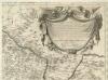
Augustissimo Romanor. Imperatori Iosepho I. Hungaria Regi Invictissimo Mappam Hanc Regni Hungariae
1 : 540000 Mollova mapová sbírka Müller, Johann Christoph
Carte de la Roumanie et pays limitrophes. Cracovie
1 : 500000 France. Service géographique de l'armée [Paris] : Service géographique de l'armée
Krakau, Przemysl, Jaroslau, Kaschau, Leutschau
1 : 750000 Krakov (Polsko : oblast) Geng, K. K. u. k. Militärgeographisches Institut
Krakau, Przemysl, Jaroslau, Kaschau, Leutschau
1 : 750000 Krakov (Polsko : oblast) Geng, K. K. u. k. Militärgeographisches Institut
Krakau, Przemyśl, Jaroslau, Kaschau, Leutschau
1 : 750000 Jarosław (Polsko) R. Lechner
![[Gradkartenblatt]](https://images-2.georeferencer.com/images/iiif/753251164176/full/,300/0/native.jpg)

