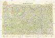
Maps of Medzilaborce

[Gradkartenblatt]
1 : 25000 Medzilaborce-oblast (Slovensko) Vojenský zeměpisný ústav
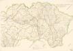
Lisko und Mezőlaborcz
1 : 75000 Bieszczady, Medzilaborce Geripp: Offiz. Schill u. Baumgarten. Terrain: Oberlt. Jonak Edl. v. Freyenwald und Zivilarb. Vogel
Lisko und Mezolaborcz.; Spezialkarte der osterreichisch-ungarischen Monarchie.
from Spezialkarte der osterreichisch-ungarischen Monarchie. Austro-Hungarian Monarchy. Militärgeographisches Institut.,
III. vojenské mapování 4268
1 : 75000
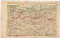
Medzilaborce a Lisko
1 : 75000 Medzilaborce (Slovensko : oblast) Vojenský zeměpisný ústav
Medzilaborce a Lisko
1 : 75000 Medzilaborce-oblast (Slovensko) Vojenský zeměpisný ústav
Lisko und Mezölaborcz
1 : 75000 Medzilaborce-oblast (Slovensko) Baumgarten K. u. k. Militärgeographisches Institut
[Gradkartenblatt]
1 : 25000 Medzilaborce-oblast (Slovensko) Vojenský zeměpisný ústav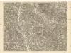
[Gradkartenblatt]
1 : 25000 Medzilaborce-oblast (Slovensko)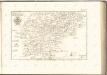

Normální mezinárodní letecká mapa.

Sanok 108, uit: Special-Karte von Mittel-Europa / nach amtlichen Quellen bearbeitet von W. Liebenow
1 : 300000 titelvariant: W. Liebenow's Mittel-Europa; Annotatie: Titel boven de bladen: W. Liebenow's Mittel-Europa Johannes Wilhelm Liebenow 1822-1897 Frankfurt a. M. : Ludwig Ravenstein
Übersichtskarte von Mitteleuropa 1:300 000
1 : 300000 Levoča-oblast (Slovensko) Reichsamt für Landesaufnahme
Stolice Zemplín a Užhorod
Komitat Zemplín, Komitat Uschgorod, ethnische Gruppe
Stolice Zemplín a Užhorod
Užhorod (Ukrajina)
Generalkarte von Zentraleuropa
Neubertova generální automapa Republiky československé
1 : 200000 Košice (Slovensko : oblast) Soukup, Jan V. Neubert a synové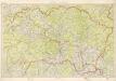
Kraj Košický a Prešovský
Bez titulu: mapy slovenských krajů
Übersichtskarte des Kampfgeländes
1 : 650000 Polen Tarnów Weltkrieg <1914-1918> Verl. Gerhard Stalling, Oldenburg
Podkarpatská Rus
1 : 500000 Berehove (Ukrajina) Fastr Eduard
Slovensko
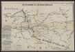
Strecke
Krakov (Polsko) K. k. Österreichische Staatsbahnen
Podkarpatská Rus
1 : 300000 Berehove (Ukrajina) Fastr Eduard
Ost-Galizien
Halič (Polsko a Ukrajina) Liesganig, Joseph im Verlage des Kunst und Industrie Comptoirs
Východní Slovensko
1 : 300000 Banská Štiavnica (Slovensko) Fastr Eduard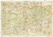
Východné Slovensko
1 : 300000 Banská Štiavnica (Slovensko) Edv. Fastr
Ober Ungern
Slovensko východní Kipferling, Karl Joseph Müller, Karl im Verlage des Kunst und Industrie Comptoir's
Ober Ungern
Slovensko východní Kipferling, Karl Joseph Müller, Karl im Verlage des Kunst und Industrie Comptoir's
![[Gradkartenblatt]](https://images-2.georeferencer.com/images/iiif/269023001480/full/,300/0/native.jpg)

