Maps of Kováčovce
[Mapový list]
1 : 25000 Slovensko Vojenský zeměpisný ústav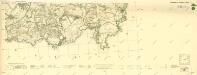
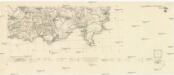
III. vojenské mapování 4763/3
1 : 25000
Sklabiná
1 : 75000 Maďarsko Vojenský zeměpisný ústav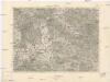
Sklabiná
1 : 75000 Maďarsko Vojenský zeměpisný ústav
Sklabiná a Salgótarján
1 : 75000 Maďarsko Vojenský zeměpisný ústav
Salgo-Tarjan und Nagyszecseny.
from Spezialkarte der osterreichisch-ungarischen Monarchie.
Mappa comitatvs Neogradiensis
1 : 160000 Novohrad (Slovensko a Maďarsko) Mikoviny, Sámuel Nicolai, Georg David Christoph
C. Neogradiensis
Ungarn Komitat Nógrád
Nográd vármegye térképe
1 : 390000 Slovensko Kogutowicz, Manó Magyar Földrajzi Intézet
Neograder-Comitat
1 : 288000 Novohrad (Slovensko a Maďarsko)
Neograder-Comitat
1 : 288000 Novohrad (Slovensko a Maďarsko)
Neograder-Comitat
1 : 288000 Novohrad (Slovensko a Maďarsko)
Nógrád vármegye
1 : 376000 Novohrad (Slovensko a Maďarsko) Görög, Demeter Festetics, György Görög
Generální mapa ČSR

Mappa Comitatvs Neogradiensis Methodo Astronomico-Geometrica concinnata
1 : 166600 Mollova mapová sbírka Mikoviny, Sámuel Nicolaï, Georg David Christoph
Stolice Novohrad
Komitat Nógrád ethnische Gruppe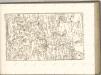

Rima-Szombat 135, uit: Special-Karte von Mittel-Europa / nach amtlichen Quellen bearbeitet von W. Liebenow
1 : 300000 titelvariant: W. Liebenow's Mittel-Europa; Annotatie: Titel boven de bladen: W. Liebenow's Mittel-Europa Johannes Wilhelm Liebenow 1822-1897 Frankfurt a. M. : Ludwig Ravenstein
Stolice Tekov. Stolice Hont
Komitat Hont, Komitat Bars, ethnische Gruppe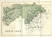
Stolice Zvolen a Gemer
Komitat Altsohl, Komitat Gemer, ethnische Gruppe
Serben im Komitat Pest 1880
Komitat Pest Serben, Siedlung Bottlik, Zsolt
Serben im Komitat Pest 1941
Komitat Pest Serben, Siedlung Bottlik, Zsolt
A szerbek aránya és száma Pest megyében 1880-ban
Komitat Pest Serben, Siedlung Bottlik, Zsolt
A szerbek aránya és száma Pest megyében 1941-ben
Komitat Pest Serben, Siedlung Bottlik, Zsolt
A szerbek aránya és száma Pest megyében 1980-ban
Komitat Pest Serben, Siedlung Bottlik, Zsolt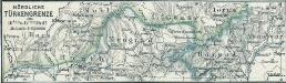
Nördliche Türkengrenze im 16ten u. 17ten Jhdt.
1 : 1850000 Osmanisches Reich / Europäischer Teil Grenze
Československo v mapách

Comitat Abaúj-Torna
1 : 290000 Košice (Slovensko : oblast)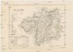
Comitat Abaúj-Torna
1 : 288000 Košice-oblast jižní (Slovensko)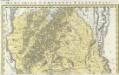
![[Mapový list]](https://images-2.georeferencer.com/images/iiif/574694158557/full/,300/0/native.jpg)

