Maps of England

MAGNAE BRITANNIAE
1 : 1340000 Anglie Homann, Johann Baptist Visscher, Nicolaes Jansz. Ioh. Bapt. Homan[n]
Composite: England.
1 : 755000 Pinkerton, John, 1758-1826
Britannia
1 : 1300000 Anglie Reichard, Christian Gottlieb Campius, D. a D. Campio
Neueste Karte von England
Grosser Hand-Atlas über alle Theile der Erde in 170 Karten Meyer, J. Verlag des Bibliographischen Instituts
[Recto], uit: England and Wales
1 : 1108000 [London] : Philip [etc.]
ANGLIA REGNUM IN OMNES SUOS DUCATUS, COMITATUS ET P[ROVINCIAS DIVISUM]
1 : 2300000 Anglie Wit, Frederik de F. de Wit
England.
1 : 1220000 Playfair, Principal
England, Wales.
1 : 2400000 Mitchell, Samuel Augustus
Ireland, Scotland.
1 : 2400000 Mitchell, Samuel Augustus
England, Wales.
1 : 2400000 Mitchell, Samuel Augustus Jr.
England, Wales.
1 : 2400000 Mitchell, Samuel Augustus
England, Wales.
1 : 2400000 Mitchell, Samuel Augustus
[Kaart], uit: W. & A. K. Johnston's touring and motoring map of England and Wales : showing the main roads, and railways
1 : 633600 Edinburgh [etc.] : Johnston
England.
1 : 1050000 Thomson, John
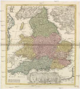
Anglia in septem Anglo-Saxonum regna omnesque hodiernas regiones ordine distincta
1 : 1400000 ededit Petrus Schenk [Amsterdam : Petrus Schenk]
Britanniae sive Angliae Regnum, tam secundum prisca Anglo-Saxonum Imperia, quam recentiorem Provinciarum divisionem accuratissime designatum
1 : 1300000 studio et sumptibus Tob. Conradi Lotter, Chalgogr. et Geogr. Augustani. [Augsburg] : [Tob. Conrad. Lotter]
Smith's new map of England and Wales with parts of Scotland : including the turnpike, and principal crossroads ... / engraved by Edw[ar]d Jones & Benj[ami]n Smith
1 : 1275000 Jones, Edward (fl. 1806); Smith, Benjamin London : C. Smith
Angleterre.
1 : 1250000 Vivien St Martin, L.
The Inland Navigation, Rail Roads, Geology and Minerals of England & Wales.
1 : 1090000 Arrowsmith, John

Geological map of England and Wales / publ. under the superintendence of the Society for the Diffusion of Useful Knowledge ; arr. by Roderick Impey Murchison ; S.P. Woodward del.; cold. by T. Malby; J. & C. Walker sculpt
1 : 1780000 Annotatie: Oorspr. uitg.: Strand : Chapman and Hall, 1843; Annotatie geografische gegevens: Met aanvullingen tot 1847 Roderick Impey Murchison 1792-1871; S.P. Woodward; T. Malby; Society for the Diffusion of Useful Knowledge London : Knight
Great Britain
A new general atlas of modern geography, consisting of a complete collection of maps of the four quarters of the globe Wyld, James James Wyld
Geological map England, Wales.
1 : 1774080 Letts, Son & Co.
Railway, statistical England, Wales.
1 : 1774080 Letts, Son & Co.
England & Wales
1 : 1075000 Anglie George Philip & Son
England.
1 : 1760000 Tanner, Henry S.
England.
1 : 1760000 Tanner, Henry S.
Kingdoms of the Anglo-Saxons.
Lavoisne, M.
England.
1 : 1900000 Radefeld, Carl Christian Franz, 1788-1874