Maps of Czech Republic

Karte der Markgrafschaft Mähren mit Schlesien
1 : 860000 Morava (Česko) Raffelsperger, Franz Rumpold, F. Franz Raffelsperger
Karte der Markgrafschaft Mähren mit Schlesien

[Mähren]
1 : 375000 Morava (Česko) Žitný
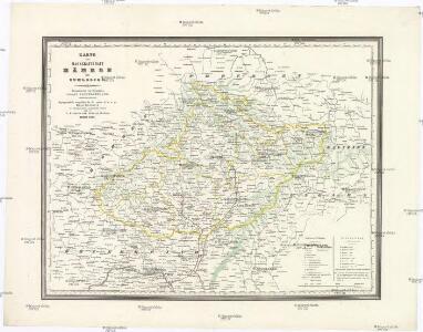
Karte der Markgrafschaft Mähren mit Schlesien
1 : 875000 Morava (Česko) Raffelsperger, Franz Franz Raffelsperger
Karte der Markgrafschaft Mähren mit Schlesien
1 : 820000 Morava (Česko) Raffelsperger, Franz Franz Raffelsperger
Karte der Markgrafschaft Maehren mit Schlesien
1 : 875000 Morava (Česko) Rumpold, F. Franz Raffelsperger
Karte der Markgrafschaft Maehren mit Schlesien
1 : 875000 Morava (Česko) Raffelsperger, Franz Franz Raffelsperger
Blatt zur Übersicht der Special Karte der Markgrafschaft Mähren und des Herzogthums Schlesien
1 : 1000000 K.K. Militärisches Geographisches Institut
Schulkarte von Mähren und Schlesien

Markgrafthum Maehren samt österreich Schlesien
1 : 475000 Morava (Česko) Reißer, Franz Tranquillo Mollo
II. vojenské mapování Klad mapových listů

Oesterreichisch-Ungarische Monarchie

Die Markgrafschaft Mahren und das Herzogthum Ober- Nieder-Schlesien
1 : 600000 Geographisches Institut (Weimar, Germany)
Morava a Rakouské Slezsko]
1 : 25000 Mollova mapová sbírka
Frühbronzezeit
Böhmen, Mähren, Archäologie
Mapa poněmčování Zemí českých
1 : 2050000 Česko Hocke, Jan Kapras, Jan
Moraviae nova et post omnes priores accuratissima delineatio / auctore I.A. Comenio ; A. Goos sculpsit
1 : 470000 Annotatie: Origineel is Blad 127 in atlas factice; Boven de kaart 4 stadsgezichten: Polna; Olmuts; Brin en Znaim; Annotatie geografische gegevens: Twee schaalstokken linksonder Johannes Amos Comenius 1592-1670; Abraham Goos ca. 1589/90-1643; Claes Jansz. Visscher 1586/1587-1652 [Amsterdam : à Nicolao Iohannide Piscatore]
Post Cours Karte für Mähren und Schlesien
Morava (Česko)
Země Moravskoslezská
1 : 1000000 Brno (Česko) Machát, František V. Neubert a synové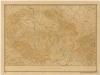
Bez titulu: Slepá mapa horstev Čech a Moravy
Železniční mapka zemí koruny české [sic]
země Koruny české F.B. Batovec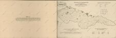
Atlas d'industrie de la république tchécoslovaque

Böhmen, Mähren und Schlesien
Česko Berghaus, Hermann Lepař, Zdeněk Justus Perthes
Hydrographische Karte der Markgrafschaft Mähren
1 : 432000 Morava (Česko) Mährischer Landes-Ausschuss
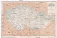
Podrobná mapa země Moravskoslezské
1 : 400000 Brno (Česko) Machát, František Kuchař, Karel V. Neubert a synové
Podrobná mapa země Moravskoslezské
1 : 400000 Brno (Česko) Machát, František V. Neubert a synové
Äneolithikum
Böhmen, Mähren, Archäologie
Jüngeres Neolithikum
Böhmen, Mähren, Archäologie
Spätlatènezeit
Böhmen, Mähren, Archäologie