Maps of Czech Republic

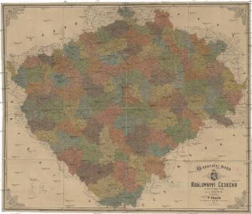
Generální mapa Království českého
1 : 220000 Čechy (Česko) Wagner, Jan Eduard Mareš, František F. Kytka
Karte des landtäflichen Grossgrund-Besitzes im Königreiche Böhmen nach der ehem. Domanial-Umgrenzung mit Angabe der positiven Grösse des Besitzes
1 : 600000 Čechy (Česko) Hickmann, Anton L. A.L. Hickmann
Karte der Kreisgerichts-Sprengel und Gerichts-Bezirke des Königreiches Böhmen nebst den fertigen und projectirten Eisenbahn-Linien
1 : 600000 Čechy (Česko) Hickmann, Anton L. A.L. Hickmann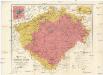
Uibersichtskarte des Königreiches Böhmen
1 : 576000 Jablonec nad Nisou (Česko : oblast) Wagner, Jan Eduard F. Kytka
Geognostisch montanistische Geschäftskarte des Kőnigreich Bőhmen
1 : 750000 Česko Schmidt z Bergenholdu, Jan Ferdinand Mecséry de Tsoor, Karl Freiherr von
Geognostisch montanistische Geschäftskarte des Kőnigreich Bőhmen
1 : 750000 Česko Schmidt z Bergenholdu, Jan Ferdinand Mecséry de Tsoor, Karl Freiherr von
Geognostisch montanistische Geschäftskarte des Kőnigreich Bőhmen
1 : 750000 Česko Schmidt z Bergenholdu, Jan Ferdinand Mecséry de Tsoor, Karl Freiherr von
Příruční mapa Království českého
1 : 600000 Česko Wagner, Jan Eduard F. Kytka
Králowstwj české
Česko Wondra, Jos. Havlík, H.
Přehledná mapa pokračovacích škol průmyslových, kupeckých a j. v Království českém
Česko c. a k. dvorní litografie A. Haase
Post= Charte vom Königreiche Böheim
mapa VKOL Kreibich, František Jakub Jindřich Herausgegeben von C.E. Rainold
Přehledná mapa úprav vodních v Království českém
1 : 500000 Čechy (Česko) Meliorační svaz v Království českém
Stellung der Blaetter
Česko
Reisekarte von Böhmen
1 : 600000 Bílina (Česko : oblast) Wagner, Jan Eduard F. Kytka
Karte des Königreiches Böhmen
1 : 430000 Čechy (Česko) Steinhauser, Anton Peucker, Karl Artaria
Neueste Handkarte von Böhmen
1 : 600000 Duchcov (Česko : oblast) Wagner, Jan Eduard F. Kytka
Králowství České
1 : 1350000 Čechy (Česko) sklad Karla André
Králowství České
Česko Schlieben Ausfeld, Johann Carl sklad Karla André
Geonomická mapa Čech

Mapa království Českého
1 : 800000 Čechy (Česko) Krečmar, Bedřich tisk a sklad Bedř. Krečmara
Karte von Böhmen
Čechy (Česko) Habel, Johann K.
Karte der confessionellen Verhältnisse des Königreiches Böhmen
1 : 600000 Čechy (Česko) Hickmann, Anton L. A.L. Hickmann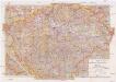
Mittelbach's neueste Specialkarte von Böhmen zum Hand- und Kontorgebrauch
1 : 300000 Česko Mittelbach Mittelbach's Verlag
Nejnovější příruční mapa Království Českého

[Čechy]
1 : 600000 Čechy (Česko)
Mapa Království českého
1 : 500000 Čechy (Česko) z uměleckého závodu Eduarda Hölzela
Geognostische Uibersichts-Karte der Kohlenführenden Formationen von Böhmen
Čechy (Česko) Hennig Verlag der J.G. Calve'schen Buchhandlung
Geognostische Uibersichts-Karte von Böhmen
Čechy (Česko) Hennig Verlag der J.G. Calve'schen Buchhandlung
Mapa jednot České obce sokolské v září 1889
Čechy (Česko) Podlipný
Mapa jednot České obce sokolské v září 1889
Čechy (Česko) Podlipný