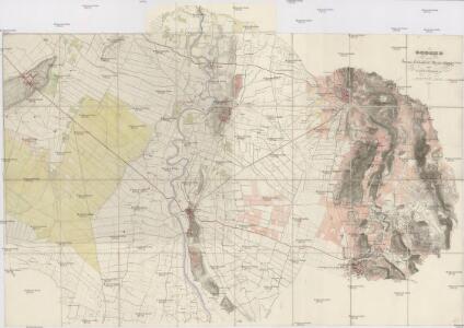
Maps of Montichiari
Gegend zwischen Lonato, Castiglione, Montechiari und Castenedolo
1 : 13500 Castenedolo (Itálie)
Landesstrich zwischen der Chiese und der Etsch 1837
1 : 21600 Blatt 1 [s.n.]
Landesstrich zwischen der Chiese und der Etsch 1837
1 : 21600 Blatt 2 [s.n.]
Schlacht bei Solferino

Territoire de Cremona
1 : 200000 Mollova mapová sbírka Mortier, Pieter Mortier, Pierre
Schlacht bei Solferino
Territorio di Cremona
1 : 220000 Mollova mapová sbírka Magini, Giovanni Antonio Magini, Giovanni Antonio
Agri Cremonensis typvs
1 Karte : Kupferdruck ; 33 x 48 cm Campi; Ortelius s.n.
Territorio di Cremona
1 : 230000 Mollova mapová sbírka Schenk, Pieter Schenk, Peter I
Verona
1 : 200000 Woerl, Joseph Edmund ; Herder, Bartholomäus Herder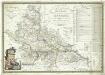
Carta topografica della provincia di Mantova
1 : 120000 Mantova (Itálie) Raineri, Giuseppe Raineri, Giuseppe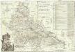
Carta topographica della provincia di Mantova
1 : 126000 Mantova (Itálie) Raineri, Giuseppe Raineri, Giuseppe


TERRITORIO | DI | CREMONA.
[Amsterdam : Joan Blaeu]
Carte Nouvelle Du Duché de Mantoue :
1 : 210000 Mollova mapová sbírka Sanson, Guillaume Covens, Johannes I
DVCATO | DI | MANTOVA
[Amsterdam : Joan Blaeu]
Territorio Di Cremona. [Karte], in: Theatrum orbis terrarum, sive, Atlas novus, Bd. 3, S. 70.
1 Karte aus Atlas Blaeu, Joan Blaeu, Willem Janszoon
Territorio Di Cremona. [Karte], in: Le théâtre du monde, ou, Nouvel atlas contenant les chartes et descriptions de tous les païs de la terre, Bd. 3, S. 72.
1 Karte aus Atlas Blaeu, Willem Janszoon und Blaeu, Joan Blaeu, Willem Janszoon
Le Duché de Mantoue
1 : 400000 Mollova mapová sbírka Nolin, Jean-Baptiste Nolin, Jean Baptiste II.
Territoria Di Cremona. [Karte], in: Novus Atlas, das ist, Weltbeschreibung, Bd. 3, S. 84.
1 Karte aus Atlas Blaeu, Joan Blaeu, Willem Janszoon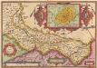
Agri Cremonensis Typus. [Karte] Cremae Ditionis Descriptio. [Nebenkarte], in: Theatrum orbis terrarum, S. 201.
1 Karte aus Atlas Ortelius, Abraham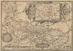
Agri Cremonensis Typus. [Karte] Cremae Ditionis Descriptio. [Nebenkarte], in: Theatrum orbis terrarum, S. 296.
1 Karte aus Atlas Ortelius, Abraham Vrients, Jan Baptista
Carte nouvelle du Duché de Mantoue : levée par ordre exprès à l'usage des armées en Italie, où sont exactement marqués les grands chemins, les routes des imperiaux &c
1 : 200000 par le Sr. Sanson, geograph. du roy A Amsterdam : chez Pierre Mortier
Ducato Di Mantova [Karte], in: Novus Atlas, das ist, Weltbeschreibung, Bd. 3, S. 87.
1 Karte aus Atlas Blaeu, Joan Blaeu, Willem Janszoon
Ducato Di Mantova [Karte], in: Le théâtre du monde, ou, Nouvel atlas contenant les chartes et descriptions de tous les païs de la terre, Bd. 3, S. 75.
1 Karte aus Atlas Blaeu, Willem Janszoon und Blaeu, Joan Blaeu, Willem Janszoon
Territorio di Cremona [Karte], in: Novus atlas absolutissimus, Bd. 5, S. 80.
1 Karte aus Atlas Janssonius Offizin
Carte Tres Particuliere du Brassan Faisant partie des Etats de la Republique de Venise
1 : 370000 Mollova mapová sbírka Nolin, Jean-Baptiste Nolin, Jean Baptiste