Maps of Germany

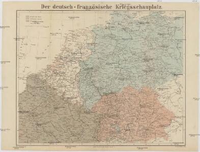
Der Deutsch-französische Kriegsschauplatz
1 : 900000 Evropa severozápadní König, Gustav Moriz Perles
Central Europe.
1 : 2000000 Hughes, William
L'Allemagne Divisée en Havte et Basse, et par Cercles, Subdivisée en Etats Ecclesiastiques, Laiques et Villes Imperiales
1 : 2400000 Mollova mapová sbírka Du Tralage, Jean Nicolas Nolin, Jean Baptiste
[Střední Evropa]
Evropa střední
Feuille 24 (C IV), uit: Carte géologique internationale de l'Europe : la carte, votée au congrès géologique international de Bologne en 1881, est exécutée conformément aux décisions d'une commission internationale, avec le concours des gouvernements, sous le dir. de M.M. Beyrich et Hauchecorne
Annotatie: Blad 48 gamme des couleurs; blad 49: bladwijzer en titelblad Heinrich Ernst Beyrich 1815-1896; Wi. Hauchecorne Berlin : Reimer / (Berlin: Institut lithographique)
Charte von Deutschland zu dem Meilen-Zeiger
1 : 222000 Německo Schreiber, Johann Georg
Dějiště války francouzsko-německé
1 : 2600000 Evropa střední
Allemagne occidentale.
1 : 2000000 Andriveau-Goujon, J.
Bojiště francouzsko-německé
Evropa severozápadní Gréger a Ferd. Dattel
Germania divisa in decem Circulos,
1 : 2400000 Mollova mapová sbírka Valk, Gerhard Valck, Gerard
West Deutschland und Ost Frankreich, Niederlande und Belgien
1 : 2000000 Belgie Kozenn, B. Hölzel, Eduard Ed. Hölzel
A new map of the Netherlands or Low Countries, shewing their principal divisions, cities, towns, rivers &c.
from A new sett of maps both of antient and present geography : wherein not only the latitude and longitude of many places are corrected according to the latest observations, but also the most remarkable differences of antient and present geography may be quickly discern'd by a bare inspection or comparing of correspondent maps, which seems to be the most natural and easy method to lead young students (for whose use the work is principally intended) unto a competent knowledge of the geographical science : together with a geographical treatise particularly adapted to the use and design of these maps / by Edward Wells, M.A. and student of Christ-Church, Oxon.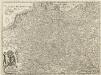
Carte von Ober u. Nieder Teutschland
1 : 4500000 Mollova mapová sbírka Vogel
Hydrographia Germaniae
Evropa střední Homann, Johann Baptist operâ Ioh. Baptistae Homani
Hydrographia Germaniae
1 : 2500000 Evropa střední Homann, Johann Baptist J.B. Homann
S. Imperium Romano-Germanicum oder Teutschland mit seinen angräntzenden Königreichen und Provincien
1 : 2420000 Evropa střední Reichelt, Julius Hogeboom, A. durch Nicolaum Visscher
S. Imperium Romano-Germanicum oder Teutschland mit seinen angräntzenden Königreichen und Provincien
1 : 2450000 Evropa střední Reichelt, Julius Hogeboom, Andries durch Nicolaum Visscher
Mappa Geographica indicans, quibus in locis per totam Germaniam bello tricennali Rex Sueciae Gustavus Adolphus, ejusque Confoederati felicia ut plurimum praelia comiserint, quas urbes tenuerint et A. 1648 amore Pacis vi tractatum Westphalicarum restituere promiserint
1 : 2500000 Mollova mapová sbírka Seutter, Matthäus Seutter, Matthäus
Accuratissima Germaniae tabula
1 : 2500000 Evropa střední Danckerts, Justus a Iusto Danckerts
Imperii Romano-Germanici in svos statvs et circvlos divisi tabvla generalis in usus iuventutis erudiendae accommodata
1 : 2560000 Evropa střední Homann, Johann Baptist Schatz, Johann Jakob Schatz
Imperii Romano-Germanici in svos statvs et circvlos divisi tabvla generalis in usus iuventutis erudiendae accommodata
1 : 2600000 Evropa střední Homann, Johann Baptist Schatz, Johann Jakob Ioh. Bapt. Homann
L'Empire d'Allemagne
1 : 2400000 Mollova mapová sbírka Jaillot, Alexis-Hubert Broen, Gerrit de Jaillot, Alexis Hubert
Die Ältesten Karten von Deutschland

Homannův atlas světa
1 : 12500000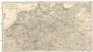
Carte itineraire de l'empire d'Allemagne et des frontieres
1 : 2140000 Německo
S[anctum] Imperium Romano-Germanicum oder Teutschland Mit Seinen Angräntzenden Königreichen Und Provincien
Reichelt, Julius; Visscher, Nicolaes; Hogeboom, Andries
Accuratissima Germaniae Tabula Denuo in lucem edita
1 : 2400000 Mollova mapová sbírka Wit, Frederik de Ottens, Josua
Accuratißima totius Germaniae Tabula Novissime in lucem edita
1 : 2400000 Mollova mapová sbírka Funck, David Homann, Johann Baptist Funck, David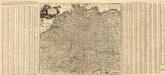
Accuratissima Germaniae Tabula
1 : 2500000 Mollova mapová sbírka Danckerts, Justus Danckerts, Justus