Maps of okres Ústí nad Labem

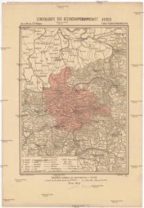
Generalkarte der Bezirkshauptmannschaft Aussig
1 : 220000 Ústí nad Labem-oblast (Česko) Wagner, Jan Eduard F. Kytka
Camp des Saxons avec le blocus forme par les Prussiens et situation des deux armees avant, et apres la bataille de Lobositz
Lovosice-oblast (Česko) Trattner, Johann Thomas Jean Thomas Trattner
Landkreis Aussig
1 : 75000 Protektorát Čechy a Morava Dienststelle für Raumordnung und Landesplanung beim Regierungspräsidenten
Wanderkarte fürs Elbetal und des angrenzenden Gebietes vom Mittel- und Erzgebirge
1 : 75000 Pirna (Německo) Kroitzsch, Carl vom Aussiger Gebirgsverein
Geologische Karte des Böhmischen Mittelgebirges und der angrenzenden Gebiete,: umfassend die Bezirke Tetschen, Aussig u. Leitmeritz
Hibsch, Josef Emanuel
Geologische Karte des Böhmischen Mittelgebirges und den angrenzenden Gebiete
1 : 100000 Děčín (Česko : oblast) Hibsch, Josef Emanuel Freier Lehrerverein für den Politischen Bezirk Tetschen
Reise Karte duch die Sächsische Schweiz

Aussig und Leitmeritz.
from Spezialkarte der osterreichisch-ungarischen Monarchie.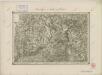
II. vojenské mapování 2
1 : 144000
Landkreise Tetschen
1 : 75000 Děčín (Česko : oblast) Dienststelle für Raumordnung und Landesplanung beim Regierungspräsidenten
Reise - Karte durch die Sächsische Schweiz

Reise Karte duch die Sächsische Schweiz
II. vojenské mapování 2
1 : 144000
Bodenbach und Tetschen.
from Spezialkarte der osterreichisch-ungarischen Monarchie.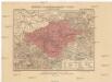
Generalkarte der Bezirkshauptmannschaft Tetschen
1 : 220000 Děčín-oblast (Česko) Wagner, Jan Eduard F. Kytka
Soubor přehledných map pro plánování a statistiku: 3752 – Litoměřice

Aussig und Leitmeritz
1 : 75000 Litoměřice (Česko : oblast) Acham, Stefan K. u. k. militär-geographisches Institut
Aussig und Leitmeritz
1 : 75000 Litoměřice (Česko : oblast) Acham, Stefan K. u. k. Militärgeographisches Institut
Aussig und Leitmeritz
1 : 75000 Litoměřice (Česko : oblast) K. u. k. Militärgeographisches Institut
Bezirk Aussig

Die Gegend zwischen Teplitz und Pirna 1813
Pirna (Německo)
Podrobná mapa Království českého
1 : 100000 Bílina (Česko : oblast) Srp, Jan Jaroslav Bursík
Geognostische Karte der Umgebungen von Bilin und Teplitz
1 : 98000 Bílina-oblast (Česko) Reuss, August Emanuel Kreibich, František Jakub Jindřich C. W. Medau'schen Buch- & Kunsthandlung
Geognostische Karte der Umgebungen von Bilin und Teplitz
1 : 100000 Bílina-oblast (Česko) Reuss, August Emanuel Kreibich, František Jakub Jindřich C.W. Medau'schen Buch- & Kunsthandlung
III. vojenské mapování 3752
1 : 75000
České středohoří

Soubor přehledných map pro plánování a statistiku: 3752 – Litoměřice

Reise-Karte durch die Sächsische Schweiz

Ústí n. L. a Litoměřice
1 : 75000 Benešov nad Ploučnicí (Česko : oblast) Vojenský zeměpisný ústav