Maps of Germany
Carte des expeditions de la gverre presente en Allemagne, ou sont exactement marqués les mouvements, les grands chemins, les routes, marches, campemens, les attaques, les sieges, batailles & les postes occupés par les trouppes autrichiennes, & par leurs alliés, par les armées suedoises, russiennes, & par celles combinées de la France & de l'Empire, contre les trouppes du roi de Prusse & Hannovriennes, depuis l'entrée de l'armée prussienne en saxe l'an 1756. jusqu a l'an 1759
1 : 1290000 Evropa střední Rizzi Zannoni, Giovanni Antonio Lauredano, Francisco Joh. Ant. Rizzi Zannoni
Deutsches Reich
Volksschul-Atlas über alle Teile der Erde Lange, Henry Druck und Verlag von Georg Westermann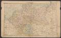
Deutsches Reich
Volksschul-Atlas über alle Teile der Erde Lange, Henry Druck und Verlag von Georg Westermann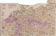
Mitteleuropa Volksdichte
1 : 6000000 Mitteleuropa Bevölkerungsdichte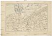
[Střední Evropa]
Evropa střední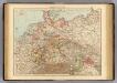
Germany.
1 : 3000000 Andree, Richard; Times (London, England)
Map of the German Empire.
1 : 3700000 Warner & Beers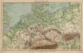
Mitteleuropa. Bodengestalt
1 : 4000000 Mitteleuropa Physische Geografie
Deutschland zur Zeit des 30 jaehrigen Krieges.
1 : 3800000 Spruner von Merz, Karl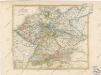
General Karte von Deutschland

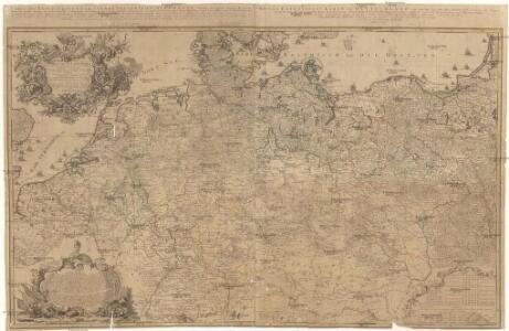
GERMANIA
1 : 2500000 Evropa střední Delisle, Guillaume Lotter, Georg F. Tobiae Conradi Lotter
Germania
1 : 2500000 Evropa střední Delisle, Guillaume Lotter, Georg F. T. C. Lotter
Germania
1 : 2500000 Evropa střední Delisle, Guillaume Brahe, Tycho Tobiae Conradi Lotter
Germania
1 : 2500000 Evropa střední Delisle, Guillaume Brahe, Tycho in officina Tobiae Conradi Lotter
Germania
1 : 2500000 Evropa střední Delisle, Guillaume Brahe, Tycho in officina Tobiae Conradi Lotter
Germania
1 : 2500000 Evropa střední Delisle, Guillaume Brahe, Tycho in officina Tobiae Conradi Lotter
Germania
1 : 2500000 Německo Delisle, Guillaume Lotter, Georg F. T. C. Lotter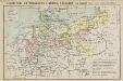
Geschichtl. Entwicklung d. Königr. Preussen vom Frieden von Tilsit (1807) bis jetzt
Deutschland
Nieuwe kaart van Duitschland, opgemaakt volgens de naukeurigste waarneemingen
1 : 7250000 [S.l.] : [s.n.]
Post- und Eisenbahnkarte des Deutschen Reichs und der angrenzenden lander
1 : 3000000 [Lieu de publication inconnu] : [éditeur inconnu]
Karte von Deutschland und einem Theile der angrenzenden Länder mit Angabe sämmtlicher Eisenbahnen
1 : 2300000 Evropa střední
L'Allemagne
1 : 2500000 L'Isle, Guillaume de Dezauche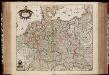
Tabula Germaniae / emendata recens per Nicolaum Joh. Piscatorem ; A. vanden Broeck sculp.
1 : 2700000 Annotatie: Linksonder: "cum privilegio; Origineel is Blad 63 in atlas factice Visscher, Claes Jansz.; Broeck, Abraham van den [Amsterdam : Nicolaes Visscher]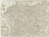
Nova Totius Germaniae descriptio Teutschland
1 : 4300000 Mollova mapová sbírka Merian, Matthäus Merian, Matthäus - dědici
Germania Augustiniana exhibens provincias ord. Fr.Fr. eremit. S. Augustini una cum monasterys et residentiis ad aßistentiam generalem utriusque Germaniae, Bohemiae, Moraviae, Poloniae, Hungariae, et Hyberniae pertinentibus
1 : 2600000 Evropa střední Seutter, Matthäus Seutter, Johann Matthäus Matthaeus Seutter
Nova Totius Germaniae Descriptio. [Karte], in: Theatrum orbis terrarum, sive, Atlas novus, Bd. 1, S. 120.
1 Karte aus Atlas Blaeu, Joan Blaeu, Willem Janszoon
Reise - Karte von Deutschland und den Nachbarstaaten

Nova Totius Germaniae Descriptio. [Karte], in: Novus Atlas, das ist, Weltbeschreibung, Bd. 1, S. 79.
1 Karte aus Atlas Blaeu, Joan Blaeu, Willem Janszoon