Maps of Germany

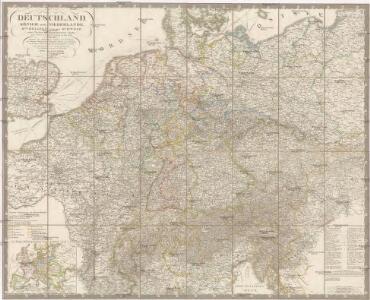
Deutschland, Königr. der Niederlande, Kgr. Belgien und die Schweiz, nebst Theilen der angränzenden Länder
1 : 1500000 Belgie Diez, F. M. Bär, Johann Christoph Justus Perthes
Deutschland, Königr. der Niederlande, Kgr. Belgien und die Schweiz, nebst Theilen der angränzenden Länder
1 : 1500000 Belgie Diez, F. M. Bär, Johann Christoph Justus Perthes
Post- Reise-Karte von Deutschland mit spezieller Angabe der Eisenbahn- und Dampfschiffahrt-Verbindungen
1 : 1820000 Evropa střední Hagedorn, Fhr. von Löhe, Wilhelm von Piloty & Loehle
[Střední a západní Evropa]
1 : 2500000 Evropa střední
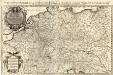
L'Empire d'Allemagne
1 : 2100000 Mollova mapová sbírka Sanson, Guillaume Jaillot, Alexis Hubert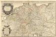
L'Empire d'Allemagne
1 : 2100000 Mollova mapová sbírka Sanson, Guillaume Jaillot, Alexis Hubert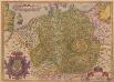
Germania. [Karte], in: Theatrum orbis terrarum, S. 102.
1 Karte aus Atlas Ortelius, Abraham
Prof. W. Liebenow's Kriegskarte von Mitteleuropa

Eisenbahn-Karte von Mittel-Europa
1 : 8200000 Evropa střední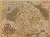
Germania. [Karte], in: Theatrum orbis terrarum, S. 40.
1 Karte aus Atlas Ortelius, Abraham
Neueste Post-Charte von Deutschland und den angränzenden Ländern : für Extraposten, Couriere, Diligencen u. Eilwagen / mit benützung der besten Materialien gezeichnet
1 : 1000000 Annotatie: Met afstandentabel Nürnberg : Bauer & Raspe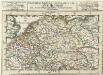
S. Imperium Romano-Germanicum =
1 : 9500000 Mollova mapová sbírka Bodenehr, Gabriel Bodenehr, Gabriel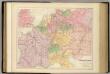
Central Europe with the Railways.
1 : 3168000 Fullarton, A. & Co.
L' Empire D'Allemagne [...] [Karte], in: Atlas nouveau, contenant toutes les parties du monde [...], Bd. 1, S. 161.
1 Karte aus Atlas Sanson, Nicolas Jaillot, Alexis Hubert und Mortier, Pieter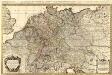
L'Empire d'Allemagne distingué suivant l'étendüe de tous les Estats, Principautés et Souverainetés qui passent ou qui ont passé jusque a present sous le nom d'Allemagne
1 : 2100000 Mollova mapová sbírka Sanson, Guillaume Covens, Johannes I
Special-Karte der Eisenbahn- Post- u[nd] Dampfschiff-Verbindungen Mittel-Europa's
1 : 1240000 Evropa střední Raab, Christian Johann Carl Koch, A. C. Flemming
Special-Karte der Eisenbahn- Post- u[nd] Dampfschiff-Verbindungen Mittel-Europa's
1 : 84000 Evropa střední Raab, Christian Johann Carl Müller, H. C. Flemming
[Übersicht der Meteorologischen Stationen in Deutschland, der Schweiz, den Niederlanden]
Erster Band, enthaltend in vier Abtheilungen die Erscheinungen der anorganischen Natur: 1. Meteorologie und Klimatographie. 2. Hydrologie und Hydrographie. 3. Geologie. 4. Tellurischer Magnetismus Humboldt, Alexander von Verlag von Justus Perthes
Karte der Eisenbahnen Mittel - Europa ́s ...
Geologische Karte von Central Europa
1 : 2640000 Evropa střední Bach, Heinrich E. Schweizerbart
Verbreitung der wichtigsten Kulturgewächse
Evropa střední F.A. Brockhaus Geogr. artist. Anstalt
Germania, V. Nova Tabula. [Karte], in: Claud. Ptolemaeus. Geographia lat. cum mappis [...], S. 347.
1 Karte aus Atlas Münster, Sebastian [und Ptolemaeus, Claudius]
Carta delle strade ferrate dell'Europa centrale
1 : 2000000 Evropa střední Kirchmayr, C. Colombo Coen
Die Verbreitung des Kropfes in Mittel-Europa
1 : 8000000 Bircher, Heinrich Benno Schwabe, Schweighauserische Verlagsbuchhandlung
Special-Karte der Eisenbahnen Deutschlands und der angrenzenden Länder
1 : 2000000 Haeberlin, R. Ramdohr
Neueste Eisenbahn-Karte von Deutschland und den angrenzenden Ländern
Evropa střední Walseck, Georg Georg Walseck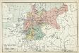
XII. Preußen innerhalb Deutschlands mit den angrenzenden Staatengebieten
1 : 6000000 Mitteleuropa, Deutschland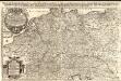
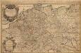
Das Heyl. Römische Reich Teutscher Nation
1 : 2100000 Mollova mapová sbírka Sanson, Guillaume Hipschmann, Sigmund Gabriel Hofmann, Johann