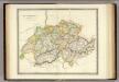
Maps of Switzerland
Nouvelle carte hydrographique et routiere de la Suisse
1 : 440000 Švýcarsko Weiss, Johann Heinrich J.H. Weiss
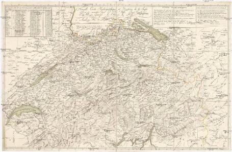
Exactißima Helvetiae Rhaetiae, Valesiae caeterorumq[ue] confoederatorum ut et finitimorum populorum regionum tabula
1 : 760000 Raetie Visscher, Nicolaus Hogeboom, Andries ex conatibus Nicolai Visscher
Exactißima Helvetiae Rhaetiae, Valesiae caeterorumq. confoederatorum ut et finitimorum populorum regionum tabula
Švýcarsko Visscher, Nicolaus Hogeboom, Andries ex conatibus Nicolai Visscher
Switzerland and the county of the Grisons, wherein is described the XIII Switz Cantons with their allies & c
1 : 760000 humbly inscrib'd to [...] the Marquiss of Harold & c. rev. by J. Senex [London] : [Brown]
Exactißima Helvetiae Rhaetiae, Valesiae Caeterorumque Confoederatorum ut et finitimorum Populorum Regionum Tabula
1 : 760000 Mollova mapová sbírka Hogeboom, Andries Schenk, Peter II
Exactißima Helvetiae Rhaetiae, Valesiae Caeterorumq; Confoederatorum ut et finitimorum Populorum Regionum Tabula
1 : 800000 Mollova mapová sbírka Visscher, Nicolaes Homann, Johann Baptist Funck, David
Die Schweiz.
1 : 800000 Stein, Christ. Gottfr. Dan.
Carte de Suisse ou sont les treize cantons leurs alliés et leurs sujets
1 Karte : Kupferdruck ; 50 x 66 cm Rouvier; Rocque; Kitchin; Bowles printed for Carington Bowles at no. 69 in St. Pauls church y.d
Carte physique et politique de la Suisse
1 Karte : Kupferdruck ; 31 x 42 cm Mentelle; Chanlaire; Blondeau chez les auteurs P. G. Chanlaire rue Geoffroy-Langevin no. 328, et E. Mentelle cour du Louvre no. 7
Carte ancienne de la Suisse
1 Karte : Kupferdruck ; 19 x 19 cm, Bildgrösse 36 x 45 cm Châtelain s.n.
Übersichtskarte des schweizerischen Pegel und Witterungsstationennetzes
1 : 600000 Topogr. Anstalt v. Wurster, Randegger & Cie
Exactissima Helvetiae, Rhaetiae, Valesiae caeterorumq. confoederatorum ut et finitimorum populorum regionum tabula
1 Karte ex conatibus Nicolai Visscher ; A. Hogeboom sculp. Visscher, [Amsterdam]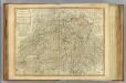
Switzerland.
1 : 540000 Robert Laurie & James Whittle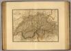
Suisse.
1 : 745000 Picquet, C.
Die Schweiz.
1 : 1020000 Flemming, Carl
Die Eÿdtgnoschafft Pünten vnd Wallis
1 Karte : Kupferdruck ; 27 x 35 cm Gyger Merian
La Suisse qui comprend: les XIII cantons, leurs sujets et leurs allié[s]
1 Karte : Kupferdruck ; 48 x 64 cm Daudet; Joubert chéz v.e Daudet Etiennette Leblon et Joubert
Die Schweiz.
1 : 1400000 Reichard, C. G.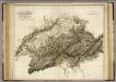
Switzerland.
1 : 615000 Playfair, Principal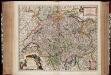
Exactissima Helvetiae Rhaetiae, Valesiae caeterorumq. confoederatorum ut et finitimorum populorum regionum tabula / ex conatibus Nicolaum Visscher Amst. Bat. ; A. Hogeboom sculp
1 : 800000 Annotatie: Cum privil. praepotentiss. Ordinum General. Belgii Foederati; Met opdracht van Nicolaus Visscher; Origineel is Blad 117 in atlas factice; Annotatie geografische gegevens: Met 5 schaalstokken; Legenda Nicolaes Jansz. Visscher jr. 1649-1702; Andries Hogeboom fl. 1665-1682 Amst. Bat. : ex conatibus Nicolai Visscher
Switzerland.
1 : 910000 Society for the Diffusion of Useful Knowledge (Great Britain)
Süd-West Deutschland und Schweiz
Adolf Stieler's Handatlas über alle Theile der Erde und über das Weltgebäude Stieler, Adolf Justus Perthes
<<Die>> Eydgnoschafft mit dero Grentzen
1 : 2000000 1 Karte Hans Conradt Geiger delinea. ; Con. Meyer sc. [J.J. Bodmer], [Zürich]
Helvetia
1 : 1700000 1 Karte [von Heinrich Heidegger] [bey Orell, Füssli und Compagnie], [Zürich]
Historischer Atlas der Schweiz
1501 - 1536 Mandrot, Louis-Alphonse de Deutsche Buchhandlung von J. Kessmann
Historischer Atlas der Schweiz
1536 - 1650 Mandrot, Louis-Alphonse de Deutsche Buchhandlung von J. Kessmann
Sud-West Deutschland Und Schweiz. Sudlicher Theil.
1 : 925000 Vogel, C.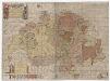
Karte der Schweiz von 1657
1 : 500000 Originaltitel: Helvetiae, Rhaetiae et Valesiae caeterorumque Confoederatorum ut et finitimorum Populorum. Tabula Geographica et Hydrographica nova et exacta. Neudruck (mittels revidierter und teilweise nachgestochener Kupferplatten) der von Hans Conrad Gyger, andere Schreibweisen: Geiger, Geyger, (1599-1674), Kartograf, Ingenieur und Amtmann des Amts Kappelerhof, von Zürich, gezeichneten und von Conrad Meyer (1618-1689), Maler, Zeichner und Radierer, von Zürich, gestochenen Originalkarte. Mit (am linken und rechten Bildrand) farbigen Wappen der Dreizehnörtigen Eidgenossenschaft sowie der elf Zugewandten Orte und mit (am linken unteren Bildrand) den Wappen der neuen Gemeinen Herrschaften Baden, Frauenfeld, Freiämter, Sargans, Rheintal, Lugano, Locarno, Mendrisio und Meinthal. Mit einer Erklärung der Zeichen. Karte aus zwei zusammensetzbaren Blättern (zwei Kupferdruckplatten). Gyger, Hans Georg (1627-1687), Maler und Amtmann des Klosteramts Küsnacht, von Zürich
Novissima Foederatorum HELVETIORUM Tabula
1 : 2600000 Švýcarsko