Maps of Böhmerwald

Přehlední mapa navržené české jího-západní-dráhy [sic]
Čechy jihozápadní (Česko)
Uibersichtskarte der projektirten böhmischen Süd-West-Bahn
Čechy (Česko)
Politická mapa republiky Československé

Strassenkarte des Koenigreiches Boehmen

Grossdeutsches Reich Sudetenländer

Bohemia Rosa omnibus saeculis cruenta, in qua plura quam 80. magna praelia commissa sunt, nunc primum hâc formâ excusa
Mollova mapová sbírka Vetter, Christoph Kilian, Wolfgang
Čechy
Čechy (Česko)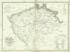
Statistisch topographische Finanz-Karte des Königreiches Boehmen
1 : 1000000 Čechy (Česko) Herz, Johann Gottlieb Haase Söhne
Karte von dem Königreiche Böheim
1 : 1104000 Česko Reilly, Franz Johann Josef von F.I.I. von Reilly
Prag, Eger, Budweis, Linz, München, Regensburg
1 : 750000 Cheb (Česko : oblast) Fendl, Josef K. u. k. Militärgeographisches Institut
Prag, Eger, Budweis, Linz, München, Regensburg
1 : 750000 Cheb (Česko : oblast) K. u. k. militär-geographisches Institut
Prag, Eger, Budweis, Linz, München, Regensburg
1 : 750000 Cheb (Česko : oblast) K. k. militär-geographisches Institut
Königreich Böhmen
Čechy (Česko)
Strassenkarte von Böhmen
1 : 450000 Čechy (Česko)
Des Königreiches Böhmen Mitte, Süden und Westen
1 : 750000 Čechy (Česko) Berghaus, Heinrich Karl Wilhelm Berghaus, Hermann Justus Perthes
Uebersichtskarte der k.k. priv. böhmischen Westbahn
1 : 320000 Čechy západní (Česko)
B.2. Prag, Eger, Budweis, Linz, München, Regensburg

Bez titulu – Wielandova mapa Čech, Moravy a Slezska
Nejstarší hroby v Čechách
Čechy (Česko)
Behemer Künigreich mit bergen und waelden gerings umb beschlossen
1 : 850000 Česko Klaudyán, Mikuláš Münster, Sebastian
Behemer Koenigreich mit Bergen und Waelden gerings vmb beschlossen
1 : 830000 Česko Klaudyán, Mikuláš
Bohemia oder das Königreich Böhmen Mitt Angretzten Ländter
1 : 83200 Mollova mapová sbírka Custos, David
Karte der Holzartenverbreitung in Protektorat Böhmen und Mähren
Svoboda, Pravdomil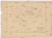
Stará hradiště v Čechách.
Čechy (Česko) Lego, František Filipovský, Karel
Mapa polesí Lomany
1 : 5000
Nordwestlicher Theil von Boehmen, enthaltend den Pilsner, Ellbogner, Saazer, Leutmeritzer und Rakonitzer Kreis
1 : 540000 Litoměřice-oblast (Česko) Kindermann, Joseph Karl Kunst und Industrie Comptoir
Podrobná nástěnná školní mapa Československé Republiky, část 1.: Čechy

Freytag & Berndt ́s: Auto-Strassenkarten

[Církevní mapa Království českého]
Čechy (Česko) Plodek, Christian František Kristián Plodek
![Přehlední mapa navržené české jího-západní-dráhy [sic]](https://images-2.georeferencer.com/images/iiif/917450413819/full/,300/0/native.jpg)

