Maps of Central Moravia

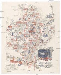
Die March
Morava, řeka-oblast
Die Kronländer Maehren und Schlesien
Morava (Česko) Marco Berra
Conjuctio Danubij cum Oder vel per Moravam et Beczwam vel per Vagum, et Olsam
Mollova mapová sbírka Vogemont, Lothar
Podrobná mapa Moravy a Slezska
1 : 400000 Brno (Česko) Machát, František V. Neubert a synové
Mapa normálních isohyet ve vegetačním období duben - červenec 1878 - 1925 v povodích Moravy a horní Odry

Markgrafschaft Mähren und Herzogthum Ober u. Nieder-Schlesien
1 : 1850000 Morava (Česko) Stieler, Adolf Mädel, Adolf Justus Perthes
Brno, Opava, Nitra
1 : 750000 Brno-oblast (Česko) Vojenský zeměpisný ústav
Die Markgrafschaft Mähren nebst dem oesterreichischen Antheile an Schlesien
1 : 490000 Morava (Česko) Weiland, Karl Ferdinand Hensgen, C. im Verlage des Geograph. Instituts
Die Markgrafschaft Mähren nebst Oesterreichisch Schlesien
1 : 807000 Morava (Česko) Weiland, Karl Ferdinand Jungmann, Carl Im Verlage de Geograph. Instituts
Die Markgrafschaft Mähren nebst Oesterreichisch Schlesien
1 : 500000 Morava (Česko) Weiland, Karl Ferdinand Jungmann, Carl Geograph. Institut
Die Markgrafschaft Mähren nebst Oesterreichisch Schlesien
1 : 530000 Morava (Česko) Weiland, Karl Ferdinand Jungmann, Carl Geograph. Institut
Die Markgrafschaft Mähren nebst Oesterreichisch Schlesien
1 : 510000 Morava (Česko) Weiland, Karl Ferdinand Jungmann, Carl im Verlage des Geograph. Instituts
Die Markgrafschaft Mähren nebst Oesterreichisch Schlesien
1 : 807000 Morava (Česko) Weiland, Karl Ferdinand Jungmann, Carl im Verlage de Geograph. Instituts
Carte générale du marquisat de Moravie divisée en six cercles dressée sur les memoires les plus nouveaux
1 : 510000 Morava (Česko) Condet, Johannes Cóvens et Mortier
Moraviae, Quae Olim Marcomannorum Sedes [Karte], in: Theatrum orbis terrarum, S. 254.
1 Karte aus Atlas Ortelius, Abraham Vrients, Jan Baptista
Moraviae, Quae Olim Marcomannorum Sedes [Karte], in: Theatrum orbis terrarum, S. 162.
1 Karte aus Atlas Ortelius, Abraham
Übersichtskarte von Mittel - Europa

Bez titulu: Přehledná mapa střední Evropy

Orohydrographisches tableau aus der überschts-karte von Mittel -Europa

Mappa geographica specialis Marchionatus Moraviae in sex circulos divisae
1 : 660000 Brno (Česko) Lotter, Tobias Conrad Lotter, Matthäus Albrecht T. C. Lotter
Mappa geographica specialis Marchionatus Moraviae in sex circulos divisae
1 : 660000 Brno (Česko) Lotter, Tobias Conrad Lotter, Matthäus Albrecht sumptibus Tobiae Conradi Lotter
Mappa geographica specialis Marchionatus Moraviae in sex circulos divisae
1 : 660000 Brno (Česko) Lotter, Tobias Conrad Lotter, Matthäus Albrecht T. C. Lotter
Mappa geographica specialis marchionatus Moraviae in sex circulos divisae
1 : 660000 Brno (Česko) Lotter, Tobias Conrad Lotter, Matthäus Albrecht T. C. Lotter
Mappa geographica specialis marchionatus Moraviae in sex circulos divisae
1 : 660000 Brno (Česko) Lotter, Tobias Conrad Lotter, Matthäus Albrecht T. C. Lotter
Moravia Marchionatus [Karte], in: Novus Atlas, das ist, Weltbeschreibung, Bd. 1, S. 188.
1 Karte aus Atlas Blaeu, Joan Blaeu, Willem Janszoon
Moravia marchionatus in sex Circulos Divisus

Tabula generalis Marchionatus Moraviae in sex circulos divisae
1 : 500000 Morava (Česko) Müller, Johann Christoph Johann Baptist Homann
Tabula generalis Marchionatus Moraviae

Mappa Geographica specialis Marchionatus Moraviae in sex Circulos divisae
1 : 660000 Mollova mapová sbírka Lotter, Tobias Conrad Lotter, Tobias Conrad